METAR & TAF KPOC
Current METAR
Observed 01:47Z
KPOC 270147Z 25013KT 10SM CLR 32/18 A2990
- Wind
- 250° @ 13 kt
- Visibility
- 10 SM
- Temp / Dew
- 32°C / 18°C
- Altimeter
- 29.90 inHg
- Clouds
- CLR
- Density alt
- 3,322 ft
- Ceiling
- Unlimited
- Rules
- VFR
Airport info & contacts
Manager on record, flight service, ARTCC, attendance schedule and pattern altitude — published by the FAA and refreshed every 28 days.
Location
- From city
- 1 NM SW
- VFR sectional
- LOS ANGELES
- ARTCC
- ZLA · LOS ANGELES
- NOTAM facility
- POC (NOTAM-D)
Airport manager
- Name
- DAVID PRICE
- Phone
- 909-593-1395
- Address
- 1615 MCKINLEY AVENUE, LA VERNE CA 91750
Flight service · Hours
- FSS RAL
- RIVERSIDE1-800-WX-BRIEF
- Attendance
- ALL
Frequencies
Tap any row to copy the frequency to your clipboard.
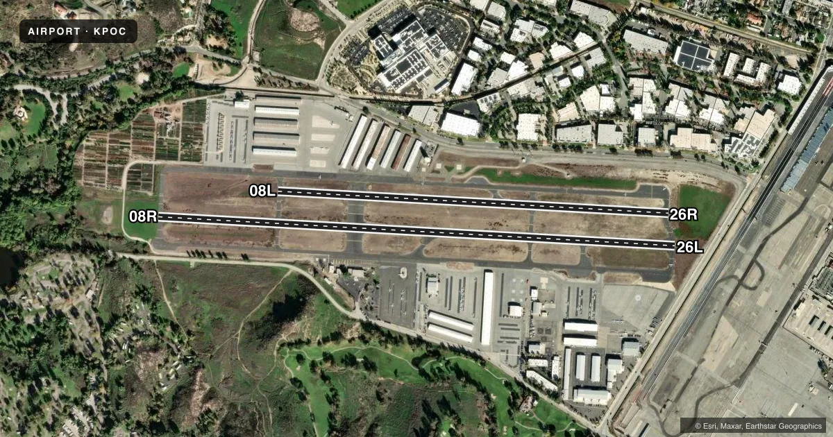
Runways & pattern
Full pagePattern entry · RWY 26L
LEFT TRAFFIC| Runway | Heading (°M) | Length | Surface | Traffic |
|---|---|---|---|---|
| 08R/26LFavored | 79° / 259° | 4,840 ft | ASPH | 08R R |
| 08L/26R | 79° / 259° | 3,661 ft | ASPH | 26R R |
Runway end performance
| End | TORA | TODA | ASDA | LDA | VGSI | Approach lights | Obstruction |
|---|---|---|---|---|---|---|---|
| 08R | — | — | — | — | PAPI 4-box left(3.76°) | — | 254', hill, 3651' from thr, 800' R of cntrln, slope 13 |
| 26L | — | — | — | — | PAPI 4-box left(3.76°) | — | 15', road, 200' from thr, 290' R of cntrln, slope 0 |
| 08L | — | — | — | — | — | — | 240', hill, 4750' from thr, 500' R of cntrln, slope 18 |
| 26R | — | — | — | — | — | — | 15', road, 540' from thr, 159' R of cntrln, slope 22 |
Declared distances in feet. TORA = takeoff run available, TODA = takeoff distance, ASDA = accelerate-stop, LDA = landing distance.
Airport sketch
Runways drawn to scale from FAA survey coordinates, rendered over satellite imagery. Not for navigation.
Approaches & charts
ILS · 1
Services on the field
Fuel grades, oxygen, maintenance, ramp storage and lighting — as declared to the FAA by the airport operator.
Fuel & services
- Fuel
- 100LLA
- Oxygen (bottled)
- Low pressure
- Airframe repair
- Major
- Power plant repair
- Major
- Other services
- AMB,AVNCS,CHTR,INSTR,RNTL,SALES,SURV
Ramp & ground
- Transient storage
- Tie-down
- Landing fee
- No fee published
- Customs
- Not available
- Lighting schedule
- SEE RMK
- Beacon schedule
- SS-SR
- Beacon
- White / Green (civil land)(WG)
- Wind indicator
- Lighted
- Segmented circle
- Yes
Fuel & FBOs
Cheapest 100LL and Jet A on the field and nearby. Always confirm with the FBO before taxi.
Airport notes
Surface conditions, obstructions, local procedures, lighting outages and other notes published with each FAA cycle.
General notes
- NOISE ABATEMENT PROCEDURES IN EFFECT CTC AMGR (909) 593-1395.
- RY 08L/26R UNLGTD.
- BIRDS AND WILDLIFE IN VICINITY OF AIRPORT.
- RAPIDLY RISING TERRAIN 1 MILE W-NW OF ARPT.
- FOR CD WHEN ATCT CLSD CTC SOCAL APCH AT 800-448-3724.
Lighting notes
- WHEN ATCT CLSD, ARPT LGT OPRS CONSLY FM 2100-0700 LCL.
Approach & departure obstructions
- 08RUNUSBL BYD 5 DEG L OF CNTRLN.
- 26LAPCH RATIO TO DSPLCD THR 50:1. APCH RATIO TO DSPLCD THR OVER +65 FT POLES 1988 FT FROM DSPLCD THR, 250 FT L, 30:1.
Other notes
- OWNERLA COUNTY CTC: PAUL MASELBAS, 626-300-4600 X4615.
VFR map & nearby airports
VFR sectional. Tap any ICAO chip to open that airport.
Key facts · KPOC
Answer card- ICAO
- KPOC
- Name
- BRACKETT FLD
- Location
- LA VERNE, CALIFORNIA
- Elevation
- 1,013.9 ft MSL
- Traffic pattern altitude
- 2,013.9 ft MSL (1,000 AGL)
- Control tower
- Towered · 0700-2100
- Total runways
- 2
- Longest runway
- 08R/26L · 4,840 ft
- Published ILS approaches
- 1
- Published frequencies
- 13
- Magnetic variation
- 14°
- Current flight rules
- VFR
- Current wind
- 250° at 13 kt
- Favored runway now
- RWY 26L
Brackett Field sits in La Verne, California. Field elevation is 1,013.9 ft MSL. The airport has two asphalt runways. The longest is 4,840 ft on 08R/26L. The control tower is open from 0700 to 2100 local. When the tower is closed, airport lighting runs continuously from 2100 to 0700 local. Pattern altitude is not published, so use the standard 1,000 ft AGL for light piston operations unless the current Chart Supplement says otherwise.
KPOC has one ILS approach for runway 26L. That matters if you are planning an arrival in lower visibility. Runway 08L/26R is unlighted. The published remarks also call out noise abatement procedures. Check the current Chart Supplement before you go. Rapidly rising terrain sits about 1 mile west-northwest of the airport. That is worth keeping in mind on departure and on the downwind side. Birds and wildlife are also reported in the area.
American Airports is on the field. It carries 100LL. If you need anything beyond that, call the FBO directly before arrival. Clearance delivery when the tower is closed goes through SoCal Approach. The airport has a busy metro feel. Plan for towered operations. Plan for noise awareness. Plan for terrain on the west side.