METAR & TAF KCCB
Current METAR
Observed 18:15Z
KCCB 261815Z AUTO 00000KT 9SM CLR 30/18 A2997 RMK AO2
- Wind
- 000° @ 0 kt
- Visibility
- 9 SM
- Temp / Dew
- 30°C / 18°C
- Altimeter
- 29.97 inHg
- Clouds
- CLR
- Density alt
- 3,528 ft
- Ceiling
- Unlimited
- Rules
- VFR
Airport info & contacts
Manager on record, flight service, ARTCC, attendance schedule and pattern altitude — published by the FAA and refreshed every 28 days.
Location
- From city
- 2 NM NW
- VFR sectional
- LOS ANGELES
- Pattern altitude
- 800 ft AGL · 2,244 ft MSL
- ARTCC
- ZLA · LOS ANGELES
- NOTAM facility
- RAL (NOTAM-D)
Airport manager
- Name
- BOB CABLE
- Phone
- 909-573-5558
- Address
- 1749 WEST 13TH STREET, UPLAND CA 91786-2199
Flight service · Hours
- FSS RAL
- RIVERSIDE1-800-WX-BRIEF
- Attendance
- DALGT
Frequencies
Tap any row to copy the frequency to your clipboard.
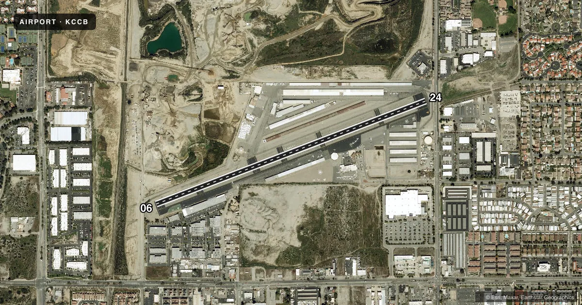
Runways & pattern
Full pagePattern entry · RWY 06
LEFT TRAFFICRunway end performance
| End | TORA | TODA | ASDA | LDA | VGSI | Approach lights | Obstruction |
|---|---|---|---|---|---|---|---|
| 06 | — | — | — | — | VASI 2-box left(4°) | — | — |
| 24 | — | — | — | — | VASI 2-box right(4°) | — | 9', road, 200' from thr, 0' R of cntrln, slope 0 |
Declared distances in feet. TORA = takeoff run available, TODA = takeoff distance, ASDA = accelerate-stop, LDA = landing distance.
Airport sketch
Runways drawn to scale from FAA survey coordinates, rendered over satellite imagery. Not for navigation.
Approaches & charts
Services on the field
Fuel grades, oxygen, maintenance, ramp storage and lighting — as declared to the FAA by the airport operator.
Fuel & services
- Fuel
- 100LLA
- Oxygen (bottled)
- HIGH/LOW
- Oxygen (bulk)
- HIGH/LOW
- Airframe repair
- Major
- Power plant repair
- Major
- Other services
- AVNCS,INSTR,RNTL,SALES
Ramp & ground
- Transient storage
- Tie-down
- Landing fee
- No fee published
- Customs
- Not available
- Lighting schedule
- SEE RMK
- Beacon schedule
- SS-SR
- Beacon
- White / Green (civil land)(WG)
- Wind indicator
- Lighted
- Segmented circle
- No
Fuel & FBOs
Cheapest 100LL and Jet A on the field and nearby. Always confirm with the FBO before taxi.
Airport notes
Surface conditions, obstructions, local procedures, lighting outages and other notes published with each FAA cycle.
General notes
- FOR CD CTC SOCAL APCH AT 800-448-3724.
Lighting notes
- ACTVT HELIPAD H1 PERIMETER LGTS - CTAF. MIRL RWY 06/24 PRESET ON LOW INTST SS-SR ACTVT HIGH INTST - CTAF.
Fuel notes
- 100LLSELF SERVICE 24 HOUR
Runway surface & condition
- 06/24GROSS PAVEMENT STRENGTH PRVDD BY ARPT OPERATOR 12500 LBS.
Approach & departure obstructions
- 24+6 FT FENCE WITH RED LGTS 50 FT FROM THLD.
- 24UNUSBL BYD 5 DEG LEFT AND 2 DEG RIGHT OF RWY CNTRLN.
- 24APCH RATIO TO DSPLCD THR OVER +9 FT ROAD 220 FT FROM DSPLCD THR; 24:1.
Other notes
- MANAGERSDUNN@CABLEAIRPORT.COM
VFR map & nearby airports
VFR sectional. Tap any ICAO chip to open that airport.
Key facts · KCCB
Answer card- ICAO
- KCCB
- Name
- CABLE
- Location
- UPLAND, CALIFORNIA
- Elevation
- 1,443.5 ft MSL
- Traffic pattern altitude
- 2,243.5 ft MSL (800 AGL)
- Control tower
- Non-towered (use CTAF)
- Total runways
- 1
- Longest runway
- 06/24 · 3,863 ft
- Published ILS approaches
- 0
- Published frequencies
- 4
- Magnetic variation
- 14°
- Current flight rules
- VFR
- Current wind
- 000° at 0 kt
- Favored runway now
- –
Cable Airport sits in Upland, California. The field elevation is 1,443.5 ft MSL. It has one runway, 06/24, which is 3,863 ft long. There is no control tower. The pattern altitude is 800 ft AGL, which is 2,243.5 ft MSL.
No ILS approaches are published here. For clearance delivery, SoCal Approach is listed in the remarks. The airport uses CTAF 123.0 and UNICOM 123.0. SoCal Approach is on 125.5 and 349.0.
Cable Airport has one on-field FBO, Cable Airport. It carries AVGAS 100LL and JET A. Self-serve 100LL is available 24 hours. Runway 06/24 lighting is preset low from sunset to sunrise. CTAF activates high intensity. That matters if you are arriving after dark.
The remarks also call out runway 24 limits. There is a fence with red lights 50 ft from the threshold. The approach to the displaced threshold crosses a road. Runway 24 is unusable beyond 5 degrees left and 2 degrees right of centerline. The field sits in the Inland Empire at a higher elevation. Expect density altitude to matter on warm days. Check the current FAA Chart Supplement for any current operational notes before you go.