METAR & TAF KAJO
Current METAR
Observed 03:56Z
KAJO 270356Z AUTO 30009KT 10SM CLR 27/18 A2990 RMK AO2 SLP119 T02670178
- Wind
- 300° @ 9 kt
- Visibility
- 10 SM
- Temp / Dew
- 27°C / 18°C
- Altimeter
- 29.90 inHg
- Clouds
- CLR
- Density alt
- 2,126 ft
- Ceiling
- Unlimited
- Rules
- VFR
Airport info & contacts
Manager on record, flight service, ARTCC, attendance schedule and pattern altitude — published by the FAA and refreshed every 28 days.
Location
- From city
- 3 NM NW
- VFR sectional
- LOS ANGELES
- ARTCC
- ZLA · LOS ANGELES
- NOTAM facility
- AJO (NOTAM-D)
Airport manager
- Name
- MOSES CORTEZ
- Phone
- 951-739-4957
- Address
- 400 SOUTH VICENTIA AVE, SUITE 225, CORONA CA 92882
Flight service · Hours
- FSS RAL
- RIVERSIDE1-800-WX-BRIEF
- Attendance
- MON-FRI · 0700-1700
Frequencies
Tap any row to copy the frequency to your clipboard.
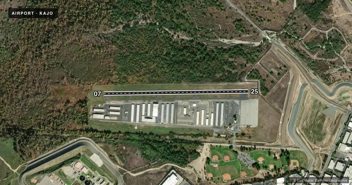
Runways & pattern
Full pagePattern entry · RWY 25
LEFT TRAFFICRunway end performance
| End | TORA | TODA | ASDA | LDA | VGSI | Approach lights | Obstruction |
|---|---|---|---|---|---|---|---|
| 07 | — | — | — | — | — | — | 40', trees, 400' from thr, 265' R of cntrln, slope 5 |
| 25 | — | — | — | — | VASI 4-box left(4°) | — | 6', fence, 200' from thr, 0' R of cntrln, slope 0 |
Declared distances in feet. TORA = takeoff run available, TODA = takeoff distance, ASDA = accelerate-stop, LDA = landing distance.
Airport sketch
Runways drawn to scale from FAA survey coordinates, rendered over satellite imagery. Not for navigation.
Approaches & charts
Services on the field
Fuel grades, oxygen, maintenance, ramp storage and lighting — as declared to the FAA by the airport operator.
Fuel & services
- Fuel
- 100LL
- Oxygen (bottled)
- Not available
- Oxygen (bulk)
- Not available
- Airframe repair
- Major
- Power plant repair
- Major
- Other services
- INSTR,RNTL,SALES
Ramp & ground
- Transient storage
- Tie-down
- Landing fee
- No fee published
- Customs
- Not available
- Lighting schedule
- SEE RMK
- Beacon schedule
- SS-SR
- Beacon
- White / Green (civil land)(WG)
- Wind indicator
- Lighted
- Segmented circle
- Yes
Fuel & FBOs
Cheapest 100LL and Jet A on the field and nearby. Always confirm with the FBO before taxi.
Airport notes
Surface conditions, obstructions, local procedures, lighting outages and other notes published with each FAA cycle.
General notes
- NOISE ABATEMENT PROCEDURES: RY 25 STRAIGHT-IN APCH NOT RECOMMENDED. AVOID FLYING OVER HOUSES ON BLUFF AT EAST END. FLY OVER WASH/CREEK. RY 07 REQUIRES A 15 DEG RIGHT TURN AT DEP END TO FOLLOW WASH/CREEK.
- UNLGTD TWR 828 FT MSL 3 MILES E OF ARPT.
- NO INTERSECTION TAKEOFFS.
- NO TOUCH AND GO OPERATIONS ON WKNDS AND HOLS.
- NO HELICOPTER TRNG AFTER 2000
- FOR CD CTC SOCAL APCH AT 800-448-3724.
Lighting notes
- ACTVT MIRL RY 07/25 VASI & REIL RY 25 - CTAF.
Approach & departure obstructions
- 25RWY 25 APCH RATIO TO DSPLCD THR 34:1.
- 07RWY 07 APCH RATIO TO DSPLCD THR 20:1
Other notes
- THIS AIRPORT HAS BEEN SURVEYED BY THE NATIONAL GEODETIC SURVEY.
- NO TURNS ONTO XW LEG TIL ACFT IS WI 300 FT OF RECOMMENDED TPA.
- MANAGERAIRPORT ADDRESS: 1900 AVIATION DRIVE, CORONA, CA 92880.
- OWNERON LEASE TO CITY OF CORONA FROM ARMY CORPS OF ENGINEERS.
VFR map & nearby airports
VFR sectional. Tap any ICAO chip to open that airport.
Key facts · KAJO
Answer card- ICAO
- KAJO
- Name
- CORONA MUNI
- Location
- CORONA, CALIFORNIA
- Elevation
- 533 ft MSL
- Traffic pattern altitude
- 1,533 ft MSL (1,000 AGL)
- Control tower
- Non-towered (use CTAF)
- Total runways
- 1
- Longest runway
- 07/25 · 3,200 ft
- Published ILS approaches
- 0
- Published frequencies
- 12
- Magnetic variation
- 14°
- Current flight rules
- VFR
- Current wind
- 300° at 9 kt
- Favored runway now
- RWY 25
Corona Muni sits in Corona, California at 533 ft MSL. It has one runway, 07/25, which is 3,200 ft long and asphalt. There is no control tower. CTAF and UNICOM are both 122.7. SoCal Approach and departure service is published on 135.4, with Class C frequencies listed in the Chart Supplement. No ILS approaches are published here.
The pattern altitude is not published. Use the standard 1,000 ft AGL for light piston operations unless current published guidance says otherwise. CW Transportation is on the field and carries 100LL. Call them directly for current service details before you go.
This field has a few items that matter on arrival. Runway 25 has a displaced threshold and the published approach ratio to that threshold is 34 to 1. Runway 07 has a 20 to 1 approach ratio to the displaced threshold. Noise abatement is important here. A straight-in to Runway 25 is not recommended. Stay over the wash and creek. Avoid the houses on the bluff at the east end. Runway 07 calls for a 15 degree right turn after departure to follow the wash and creek. There is also an unlighted tower 828 ft MSL about 3 miles east of the airport. No touch and go operations are allowed on weekends and holidays. No intersection takeoffs are published.