METAR & TAF L65
L65 does not publish a METAR.
Showing the nearest reporting station: KRIV (MARCH ARB) · 7.3 NM away. Conditions at L65 may differ.
METAR · KRIV
Observed 16:55Z
KRIV 261655Z 00000KT 10SM FEW140 FEW190 33/12 A2993 RMK AO2A SLP117 T03250121
- Wind
- 000° @ 0 kt
- Visibility
- 10 SM
- Temp / Dew
- 33°C / 12°C
- Altimeter
- 29.93 inHg
- Clouds
- FEW
- Density alt
- 3,900 ft
- Ceiling
- Unlimited
- Rules
- VFR
Airport info & contacts
Manager on record, flight service, ARTCC, attendance schedule and pattern altitude — published by the FAA and refreshed every 28 days.
Location
- From city
- 1 NM SE
- VFR sectional
- LOS ANGELES
- ARTCC
- ZLA · LOS ANGELES
- NOTAM facility
- RAL (NOTAM-D)
Airport manager
- Name
- PAT CONATSER
- Phone
- 951-657-1664
- Address
- P.O. BOX 1823, PERRIS CA 92370
Flight service · Hours
- FSS RAL
- RIVERSIDE1-800-WX-BRIEF
- Attendance
- DAWN-DUSK
Frequencies
Tap any row to copy the frequency to your clipboard.
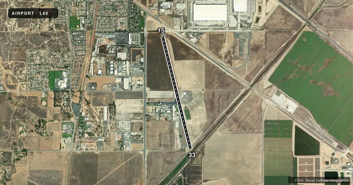
Runways & pattern
Full pagePattern entry · RWY 15
RIGHT TRAFFICRunway end performance
| End | TORA | TODA | ASDA | LDA | VGSI | Approach lights | Obstruction |
|---|---|---|---|---|---|---|---|
| 15 | — | — | — | — | — | — | 30', trees, 1190' from thr, 0' R of cntrln, slope 39 |
Declared distances in feet. TORA = takeoff run available, TODA = takeoff distance, ASDA = accelerate-stop, LDA = landing distance.
Airport sketch
Runways drawn to scale from FAA survey coordinates, rendered over satellite imagery. Not for navigation.
Approaches & charts
Services on the field
Fuel grades, oxygen, maintenance, ramp storage and lighting — as declared to the FAA by the airport operator.
Fuel & services
- Fuel
- 100LLA
- Oxygen (bottled)
- Not available
- Oxygen (bulk)
- Not available
- Airframe repair
- Major
- Power plant repair
- Major
- Other services
- CHTR,PAJA
Ramp & ground
- Transient storage
- Tie-down
- Landing fee
- No fee published
- Customs
- Not available
- Wind indicator
- Yes
- Segmented circle
- Yes
Fuel & FBOs
Cheapest 100LL and Jet A on the field and nearby. Always confirm with the FBO before taxi.
Airport notes
Surface conditions, obstructions, local procedures, lighting outages and other notes published with each FAA cycle.
General notes
- EXTSV ULTRALIGHT & PARACHUTING ACTIVITIES DAILY; DO NOT OVERFLY AIRPORT; AVOID AIRSPACE ADJ EAST. ULTRALIGHTS ON & INVOF ARPT. ULTRALIGHT AND PARACHUTING ACTIVITIES CAN BE MONITORED ON FREQ 122.775.
- (A70) FUEL AVBL FOR EMERG USE ONLY.
- FOR CD CTC SOCAL APCH AT 800-448-3724.
Approach & departure obstructions
- 15APCH RATIO TO DSPLCD THR 20:1.
- 33APCH RATIO TO DSPLCD THLD 20:1.
Other notes
- EXISTED PRIOR TO 5/15/59.
- MANAGERMAIN OFC TO LEAVE MSGS W/SECY - 951-657-3904; FAX: 951-657-6178. EMAIL: SKYDIVEPERRISPAT@AOL.COM
VFR map & nearby airports
VFR sectional. Tap any ICAO chip to open that airport.
Key facts · L65
Answer card- ICAO
- L65
- Name
- PERRIS VALLEY
- Location
- PERRIS, CALIFORNIA
- Elevation
- 1,413 ft MSL
- Traffic pattern altitude
- 2,413 ft MSL (1,000 AGL)
- Control tower
- Non-towered (use CTAF)
- Total runways
- 1
- Longest runway
- 15/33 · 5,100 ft
- Published ILS approaches
- 0
- Published frequencies
- 1
- Magnetic variation
- 14°
- Current flight rules
- VFR
- Current wind
- 000° at 0 kt
- Favored runway now
- –
Perris Valley Airport sits in Perris, California. Field elevation is 1,413 ft MSL. The airport has one runway. Runway 15/33 is 5,100 ft of asphalt, which is the longest runway on the field. There is no control tower. CTAF is 122.775.
No ILS approaches are published here. Pattern altitude is not published, so use the standard 1,000 ft AGL for light piston operations unless the current Chart Supplement says otherwise. The field is active with ultralight and parachuting traffic every day. Do not overfly the airport. Avoid the airspace adjacent to the east. Monitor 122.775 for ultralight and parachute activity.
Fuel is listed for emergency use only. There are no on-field FBOs listed in the facts. For clearance delivery, contact SoCal Approach at 800-448-3724. The published remarks also note displaced threshold approach ratios of 20 to 1 on both runway ends. That makes obstacle awareness important on arrival and departure. Pilots should expect a busy non-towered environment with mixed traffic and plan extra attention to traffic calls, pattern discipline and spacing.