METAR & TAF KBNG
KBNG does not publish a METAR.
Showing the nearest reporting station: KHMT (HEMET-RYAN) · 14.2 NM away. Conditions at KBNG may differ.
METAR · KHMT
Observed 11:15Z
KHMT 271115Z AUTO 22004KT 10SM CLR 21/15 A2997 RMK AO2
- Wind
- 220° @ 4 kt
- Visibility
- 10 SM
- Temp / Dew
- 21°C / 15°C
- Altimeter
- 29.97 inHg
- Clouds
- CLR
- Density alt
- 3,414 ft
- Ceiling
- Unlimited
- Rules
- VFR
Airport info & contacts
Manager on record, flight service, ARTCC, attendance schedule and pattern altitude — published by the FAA and refreshed every 28 days.
Location
- From city
- 1 NM SE
- VFR sectional
- LOS ANGELES
- ARTCC
- ZLA · LOS ANGELES
- NOTAM facility
- RAL (NOTAM-D)
Airport manager
- Name
- CARL SZOYKA
- Phone
- 951-922-3286
- Address
- 176 EAST LINCOLN STREET, PO BOX 998, BANNING CA 92220-0998
Flight service · Hours
- FSS RAL
- RIVERSIDE1-800-WX-BRIEF
- Attendance
- MON-FRI · 0900-1530
Frequencies
Tap any row to copy the frequency to your clipboard.
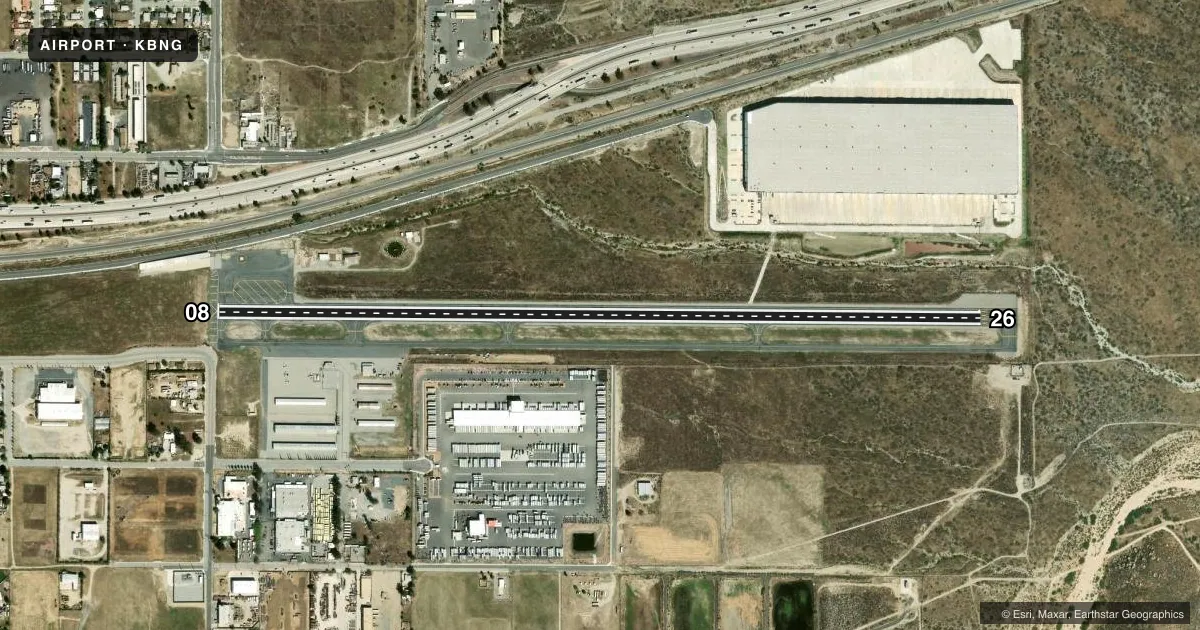
Runways & pattern
Full pagePattern entry · RWY 26
RIGHT TRAFFICRunway end performance
| End | TORA | TODA | ASDA | LDA | VGSI | Approach lights | Obstruction |
|---|---|---|---|---|---|---|---|
| 26 | — | — | — | — | PAPI 2-box left(3.5°) | — | — |
Declared distances in feet. TORA = takeoff run available, TODA = takeoff distance, ASDA = accelerate-stop, LDA = landing distance.
Airport sketch
Runways drawn to scale from FAA survey coordinates, rendered over satellite imagery. Not for navigation.
Approaches & charts
Services on the field
Fuel grades, oxygen, maintenance, ramp storage and lighting — as declared to the FAA by the airport operator.
Fuel & services
- Fuel
- 100LL
- Oxygen (bottled)
- Not available
- Oxygen (bulk)
- Not available
- Airframe repair
- Not available
- Power plant repair
- Not available
Ramp & ground
- Transient storage
- Tie-down
- Landing fee
- No fee published
- Customs
- Not available
- Lighting schedule
- SEE RMK
- Beacon schedule
- SS-SR
- Beacon
- White / Green (civil land)(WG)
- Wind indicator
- Lighted
- Segmented circle
- Yes
Fuel & FBOs
Cheapest 100LL and Jet A on the field and nearby. Always confirm with the FBO before taxi.
Airport notes
Surface conditions, obstructions, local procedures, lighting outages and other notes published with each FAA cycle.
General notes
- NO INTERSECTION TAKEOFFS TO THE WEST.
- RY 08/26 NO STRAIGHT-IN LANDINGS.
- RWY 26 AFTER TAKEOFF AVOID OVERFLYING HOUSES 4 MILES WEST.
- FOR CD CTC LOS ANGELES ARTCC AT 661-575-2079.
Lighting notes
- ACTVT MIRL RWY 08/26 - CTAF.
Fuel notes
- 100LLFUEL AVBL WITH 24 HR SELF SVC CREDIT CARD. FUEL APN NOT LEVEL AND ACFT MAY NOT FILL COMPLETELY.
Other notes
- 1FOR ARPT ATTENDANT CALL (951) 922-3320.
VFR map & nearby airports
VFR sectional. Tap any ICAO chip to open that airport.
Key facts · KBNG
Answer card- ICAO
- KBNG
- Name
- BANNING MUNI
- Location
- BANNING, CALIFORNIA
- Elevation
- 2,222.4 ft MSL
- Traffic pattern altitude
- 3,222.4 ft MSL (1,000 AGL)
- Control tower
- Non-towered (use CTAF)
- Total runways
- 1
- Longest runway
- 08/26 · 4,955 ft
- Published ILS approaches
- 0
- Published frequencies
- 2
- Magnetic variation
- 14°
- Current flight rules
- VFR
- Current wind
- 220° at 4 kt
- Favored runway now
- RWY 26
Banning Muni sits in Banning, California. The field elevation is 2,222.4 ft MSL. It has one runway, 08/26, which is 4,955 ft long. There is no control tower. CTAF and UNICOM are both 122.8. No ILS approaches are published here.
The pattern altitude is not published in the facts, so use the standard 1,000 ft AGL for light piston traffic unless the current Chart Supplement says otherwise. The airport has one on-field FBO, Banning Municipal Airport. It carries 100LL. Fuel is available with 24-hour self-service credit card. The fuel apron is not level, so plan your parking and fueling with that in mind.
A few published remarks matter here. After takeoff from runway 26, avoid overflying houses 4 miles west. No intersection takeoffs to the west are permitted. Runway 08/26 does not allow straight-in landings. Medium intensity runway lights are pilot-activated on the CTAF. This is a high-elevation field in the Banning area, so expect performance to matter on warm days. Check the current Chart Supplement for any other local procedures before you go.