METAR & TAF L35
Current METAR
Observed 19:55Z
KL35 261955Z AUTO 19011G17KT 10SM FEW075 SCT110 SCT250 27/09 A3036 RMK AO2 T02740092 $
- Wind
- 190° @ 11G17 kt
- Visibility
- 10 SM
- Temp / Dew
- 27°C / 9°C
- Altimeter
- 30.36 inHg
- Clouds
- SCT
- Density alt
- 9,267 ft
- Ceiling
- Unlimited
- Rules
- VFR
Airport info & contacts
Manager on record, flight service, ARTCC, attendance schedule and pattern altitude — published by the FAA and refreshed every 28 days.
Location
- From city
- 0 NM W
- VFR sectional
- LOS ANGELES
- Pattern altitude
- 1,200 ft AGL · 7,952 ft MSL
- ARTCC
- ZLA · LOS ANGELES
- NOTAM facility
- RAL (NOTAM-D)
Airport manager
- Name
- RYAN GOSS
- Phone
- 909-585-3219
- Address
- PO BOX 755, BIG BEAR CITY CA 92314-0755
Flight service · Hours
- FSS RAL
- RIVERSIDE1-800-WX-BRIEF
- Attendance
- 0800-1700
Frequencies
Tap any row to copy the frequency to your clipboard.
Runways & pattern
Full pagePattern entry · RWY 26
LEFT TRAFFICRunway end performance
| End | TORA | TODA | ASDA | LDA | VGSI | Approach lights | Obstruction |
|---|---|---|---|---|---|---|---|
| 08 | — | — | — | — | PAPI 2-box left(4.3°) | — | — |
| 26 | — | — | — | — | PAPI 2-box left(4.3°) | — | 40', trees, 1000' from thr, 100' R of cntrln, slope 20 |
Declared distances in feet. TORA = takeoff run available, TODA = takeoff distance, ASDA = accelerate-stop, LDA = landing distance.
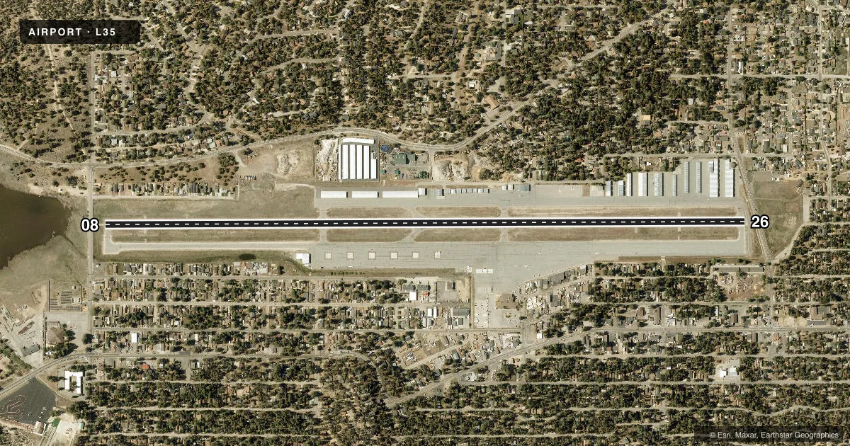
Airport sketch
Runways drawn to scale from FAA survey coordinates, rendered over satellite imagery. Not for navigation.
Approaches & charts
Services on the field
Fuel grades, oxygen, maintenance, ramp storage and lighting — as declared to the FAA by the airport operator.
Fuel & services
- Fuel
- 100LLA
- Oxygen (bottled)
- Not available
- Oxygen (bulk)
- Not available
- Airframe repair
- Minor
- Power plant repair
- Minor
- Other services
- AMB,CHTR
Ramp & ground
- Transient storage
- Tie-down
- Hangar
- Landing fee
- No fee published
- Customs
- Not available
- Lighting schedule
- SEE RMK
- Beacon schedule
- SS-SR
- Beacon
- White / Green (civil land)(WG)
- Wind indicator
- Lighted
- Segmented circle
- Yes
Fuel & FBOs
Cheapest 100LL and Jet A on the field and nearby. Always confirm with the FBO before taxi.
Airport notes
Surface conditions, obstructions, local procedures, lighting outages and other notes published with each FAA cycle.
General notes
- MOUNTAINS ALL QUADRANTS; PEAK HAZARD LGTS SE; S; & NW.
- <EXTREME NOISE SENSITIVE AREA; PRACTICE (FLY QUIET) PROCEDURES IN THE INTEREST OF NOISE ABATEMENT.
- NOISE ABATEMENT PROCEDURES; AVOID OVERFLYING OF HIGH SCHOOL 1 MILE EAST AT ALL TIMES.
- ON TKOF MAKE 10 DEG LEFT TURN AT END OF RY TO AVOID HOUSING TO EAST AND ELEMENTARY SCHOOL TO WEST OF ARPT.
- FOR CD CTC LOS ANGELES ARTCC AT 661-575-2079.
Lighting notes
- ACTVT MIRL RWY 08/26 - CTAF. PAPI RWYS 08 & 26 OPER CONSLY.
Fuel notes
- 100LL100LL AVBL 24 HOUR SELF SERVICE.
- AJET A FUEL AVBL 0800-1600 LCL, SELF-SERVICE AFTER HOURS.
Approach & departure obstructions
- 08ROAD & 6' FENCE 110' FM THR PERPENDICULAR TO CNTRLN.
- 26ROAD & 6' FENCE 100' FM THR 125' RIGHT.
- 08UNUSBL BYD 8 DEGS LEFT OF RWY CNTRLN.
- 08APCH RATIO TO DSPLCD THR OVER +15' ROAD 480' FM DSPLCD THR 32:1
- 26RWY 26 APCH RATIO TO DSPLCD THR 20:1; APCH RATIO TO DSPLCD THR OVER +50 FT TREES 1000 FT FM DSPLCD THR 100 FT LEFT 20:1.
Other notes
- THIS AIRPORT HAS BEEN SURVEYED BY THE NATIONAL GEODETIC SURVEY.
VFR map & nearby airports
VFR sectional. Tap any ICAO chip to open that airport.
Key facts · L35
Answer card- ICAO
- L35
- Name
- BIG BEAR CITY
- Location
- BIG BEAR CITY, CALIFORNIA
- Elevation
- 6,752.4 ft MSL
- Traffic pattern altitude
- 7,952.4 ft MSL (1,200 AGL)
- Control tower
- Non-towered (use CTAF)
- Total runways
- 1
- Longest runway
- 08/26 · 5,850 ft
- Published ILS approaches
- 0
- Published frequencies
- 2
- Magnetic variation
- 14°
- Current flight rules
- VFR
- Current wind
- 190° at 11 kt
- Favored runway now
- RWY 26
Big Bear City Airport (L35) is in Big Bear City, California. The field elevation is 6,752.4 ft MSL. It has one runway, 08/26, which is 5,850 ft long. There is no control tower. CTAF and UNICOM are both 122.725. No ILS approaches are published.
Pattern altitude is 1,200 ft AGL, which is 7,952.4 ft MSL. That matters here because the airport sits high in the mountains. Expect performance planning to matter on every leg. The published remarks also call this an extreme noise sensitive area. Avoid overflying the high school one mile east. Use quiet procedures. On takeoff, plan a 10 degree left turn at the end of the runway to help avoid housing to the east and the elementary school to the west.
Big Bear City Airport, the on-field FBO, carries 100LL, Jet A and Jet A Prist. 100LL is available 24-hour self-service. Jet A is available from 0800 to 1600 local time. Self-service is available after hours. The field has mountains in all quadrants. Hazard lights are noted southeast, south and northwest. Runway 08 has a visual glide slope indicator limitation beyond 8 degrees left of centerline. Check the current FAA Chart Supplement and call the airport operator or the FBO directly before arrival for any current operational details.