METAR & TAF L22
L22 does not publish a METAR.
Showing the nearest reporting station: KPSP (PALM SPRINGS INTL) · 18.7 NM away. Conditions at L22 may differ.
METAR · KPSP
Observed 04:53Z
KPSP 270453Z 00000KT 10SM CLR 36/17 A2984 RMK AO2 SLP098 T03610172
- Wind
- 000° @ 0 kt
- Visibility
- 10 SM
- Temp / Dew
- 36°C / 17°C
- Altimeter
- 29.84 inHg
- Clouds
- CLR
- Density alt
- 6,617 ft
- Ceiling
- Unlimited
- Rules
- VFR
Airport info & contacts
Manager on record, flight service, ARTCC, attendance schedule and pattern altitude — published by the FAA and refreshed every 28 days.
Location
- From city
- 1 NM E
- VFR sectional
- LOS ANGELES
- ARTCC
- ZLA · LOS ANGELES
- NOTAM facility
- RAL (NOTAM-D)
Airport manager
- Name
- CHRIS SALCICCIOLI
- Phone
- 760-401-0469
- Address
- PO BOX 2527, YUCCA VALLEY CA 92286
Flight service · Hours
- FSS RAL
- RIVERSIDE1-800-WX-BRIEF
- Attendance
- IREG
Frequencies
Tap any row to copy the frequency to your clipboard.
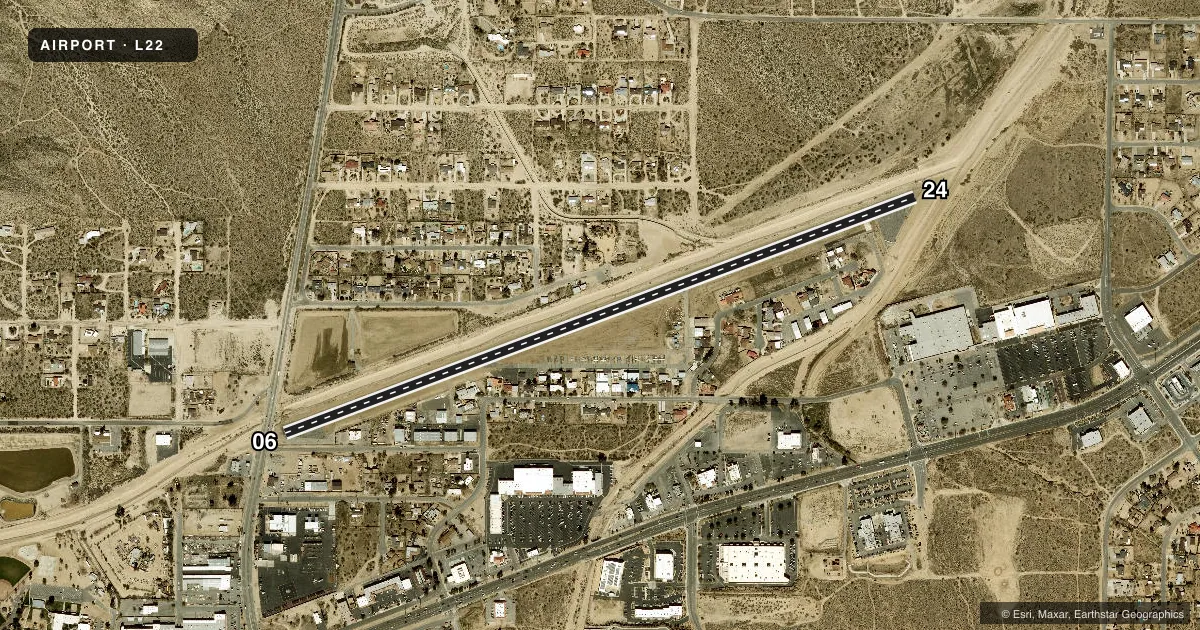
Runways & pattern
Full pagePattern entry · RWY 06
RIGHT TRAFFICRunway end performance
| End | TORA | TODA | ASDA | LDA | VGSI | Approach lights | Obstruction |
|---|---|---|---|---|---|---|---|
| 06 | — | — | — | — | — | — | 50', tree, 1500' from thr, 200' R of cntrln, slope 26 |
| 24 | — | — | — | — | — | — | 25', trees, 940' from thr, 100' R of cntrln, slope 29 |
Declared distances in feet. TORA = takeoff run available, TODA = takeoff distance, ASDA = accelerate-stop, LDA = landing distance.
Airport sketch
Runways drawn to scale from FAA survey coordinates, rendered over satellite imagery. Not for navigation.
Approaches & charts
Services on the field
Fuel grades, oxygen, maintenance, ramp storage and lighting — as declared to the FAA by the airport operator.
Fuel & services
- Fuel
- Not available
- Oxygen (bottled)
- Not available
- Oxygen (bulk)
- Not available
- Airframe repair
- Minor
- Power plant repair
- Minor
Ramp & ground
- Transient storage
- Tie-down
- Landing fee
- No fee published
- Customs
- Not available
- Lighting schedule
- SEE RMK
- Wind indicator
- Lighted
- Segmented circle
- Yes
Fuel & FBOs
Cheapest 100LL and Jet A on the field and nearby. Always confirm with the FBO before taxi.
Airport notes
Surface conditions, obstructions, local procedures, lighting outages and other notes published with each FAA cycle.
General notes
- RY 06 CALM WIND RY.
- NOISE ABATEMENT PROCEDURES IN EFFECT CTC ARPT MANAGER AT 760-401-0816.
- FOR CD CTC SOCAL APCH AT 800-448-3724.
- PRKG OR RUNUPS WI 125 FT OF RWY CNTRLN ARE NOT ALLOWED; RUNUPS FOR RWY 24 MUST BE DONE ON THE RAMP SE OF THE RWY 24 THLD.
- THE TXL SW OF RWY 24 IS FOR EXCLV USE OF THE TWO EXISTING HNGRS.
Lighting notes
- ACTVT MIRL RY 06/24 - CTAF.
Approach & departure obstructions
- 06+6 FT FENCE 0-75 FT FM EOR 60 FT L AND +2 FT FENCE 75 FT FM EOR 60-125 FT R; +5 FT SIGN 82 FT FM RY END 100 FT R; +11 FT ROAD 190 FT FM RY END 125 FT R TO 90 FT FM RY END 125 FT L.
- 24+6 FT OBSTRUCTION LIGHTED FENCE 10 FT FM EOR 45 FT L TO 125 FT R.
- 06RWY 06 APCH RATIO TO DSPLCD THLD 20:1.
- 24APCH RATIO 50:1 TO DSPLCD THR.
Other notes
- ESTABD PRIOR TO 5/15/59.
VFR map & nearby airports
VFR sectional. Tap any ICAO chip to open that airport.
Key facts · L22
Answer card- ICAO
- L22
- Name
- YUCCA VALLEY
- Location
- YUCCA VALLEY, CALIFORNIA
- Elevation
- 3,224 ft MSL
- Traffic pattern altitude
- 4,224 ft MSL (1,000 AGL)
- Control tower
- Non-towered (use CTAF)
- Total runways
- 1
- Longest runway
- 06/24 · 4,363 ft
- Published ILS approaches
- 0
- Published frequencies
- 2
- Magnetic variation
- 14°
- Current flight rules
- VFR
- Current wind
- 000° at 0 kt
- Favored runway now
- –
Yucca Valley Airport (L22) sits in Yucca Valley, California at 3,224 ft MSL. It has one runway, 06/24, which is 4,363 ft long and asphalt. There is no control tower. CTAF and UNICOM are both 123.0. No ILS approaches are published here.
The pattern altitude is not published. Use the standard 1,000 ft AGL pattern unless current local guidance says otherwise. Runway 06 is the calm wind runway. Medium intensity runway lights on 06/24 are pilot-activated through the CTAF. Published noise abatement procedures are in effect. Contact the airport manager at 760-401-0816 before you go if you need the local details.
This is a high-elevation desert field, so expect density altitude to matter on warm days. The published remarks also call out runway 06 and runway 24 obstruction notes near the displaced thresholds. Parking or runups within 125 feet of the runway centerline are not allowed. Runups for runway 24 must be done on the ramp southeast of the runway 24 threshold. There are no on-field FBOs listed, so verify services with the airport operator or call the field directly before arrival. For clearance delivery, contact SoCal Approach at 800-448-3724.