METAR & TAF KUDD
KUDD does not publish a METAR.
Showing the nearest reporting station: KTRM (JACQUELINE COCHRAN RGNL) · 9.3 NM away. Conditions at KUDD may differ.
METAR · KTRM
Observed 22:52Z
KTRM 222252Z AUTO 14007KT 10SM CLR 43/12 A2971 RMK AO2 SLP062 T04330122
- Wind
- 140° @ 7 kt
- Visibility
- 10 SM
- Temp / Dew
- 43°C / 12°C
- Altimeter
- 29.71 inHg
- Clouds
- CLR
- Density alt
- 3,711 ft
- Ceiling
- Unlimited
- Rules
- VFR
Airport info & contacts
Manager on record, flight service, ARTCC, attendance schedule and pattern altitude — published by the FAA and refreshed every 28 days.
Location
- From city
- 13 NM E
- VFR sectional
- LOS ANGELES
- ARTCC
- ZLA · LOS ANGELES
- NOTAM facility
- RAL (NOTAM-D)
Airport manager
- Name
- ANN GOODWYN
- Phone
- 760-345-2558
- Address
- 79880 AVE. 42, BERMUDA DUNES CA 92203
Flight service · Hours
- FSS RAL
- RIVERSIDE1-800-WX-BRIEF
- Attendance
- SEE RMKS
Frequencies
Tap any row to copy the frequency to your clipboard.
Runways & pattern
Full pagePattern entry · RWY 10
LEFT TRAFFICRunway end performance
| End | TORA | TODA | ASDA | LDA | VGSI | Approach lights | Obstruction |
|---|---|---|---|---|---|---|---|
| 10 | — | — | — | — | — | — | 6', fence, 200' from thr, 125' R of cntrln, slope 0 |
| 28 | — | — | — | — | VASI 2-box left(3°) | — | 37', road, 750' from thr, 150' R of cntrln, slope 14 |
Declared distances in feet. TORA = takeoff run available, TODA = takeoff distance, ASDA = accelerate-stop, LDA = landing distance.
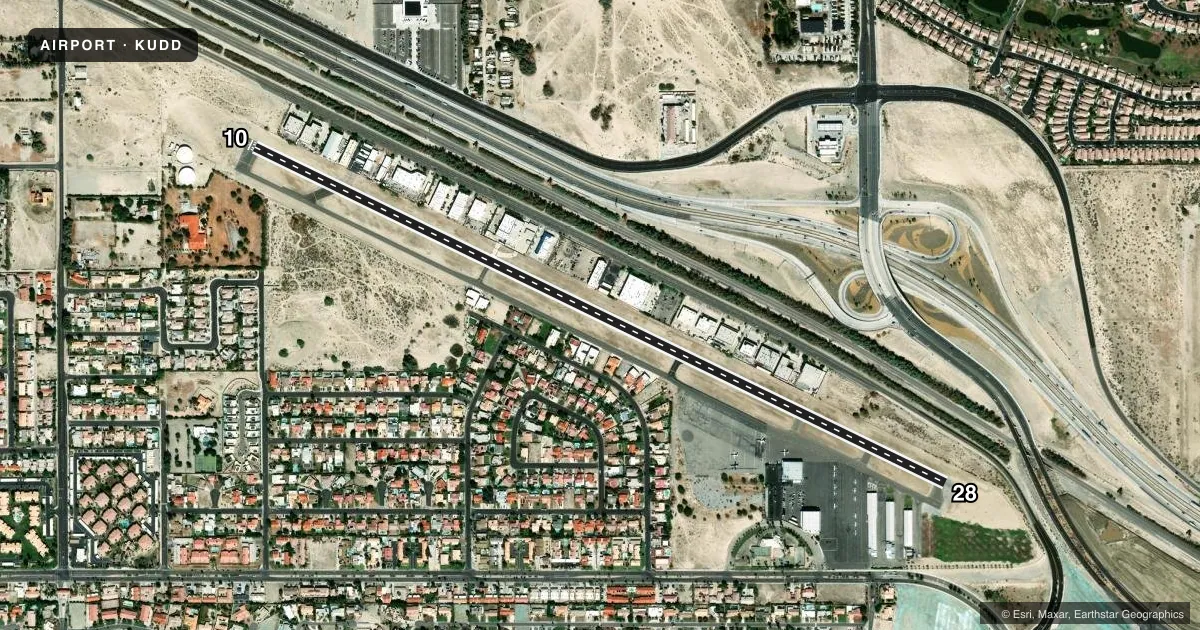
Airport sketch
Runways drawn to scale from FAA survey coordinates, rendered over satellite imagery. Not for navigation.
Approaches & charts
Services on the field
Fuel grades, oxygen, maintenance, ramp storage and lighting — as declared to the FAA by the airport operator.
Fuel & services
- Fuel
- 100LLAA+
- Oxygen (bottled)
- Low pressure
- Airframe repair
- Major
- Power plant repair
- Major
- Other services
- INSTR,RNTL,SALES
Ramp & ground
- Transient storage
- Tie-down
- Hangar
- Landing fee
- Yes
- Customs
- Not available
- Lighting schedule
- SEE RMK
- Beacon schedule
- SS-SR
- Beacon
- White / Green (civil land)(WG)
- Wind indicator
- Lighted
- Segmented circle
- Yes
Fuel & FBOs
Cheapest 100LL and Jet A on the field and nearby. Always confirm with the FBO before taxi.
Airport notes
Surface conditions, obstructions, local procedures, lighting outages and other notes published with each FAA cycle.
General notes
- NO AGRI FLIGHTS EXCP BY PPR ARPT MGR.
- FOR NOISE ABATEMENT PROCEDURES CALL AMGR (760) 345-2558.
- ARPT CLSD TO TURBINE PWRD ACFT 2300-0600 LCL; EXCP MIL, LAW ENFORCEMENT, EMS ACFT.
- PARL TWY CLSD ACFT WING SPAN GREATER THAN 68 FT.
- 24 HR EMERG NR 760-609-4414.
- FUEL AVBL 0600-2000.
- ARINC FREQ 129.7 AVBL TO CTC FBO FOR SVCS ONLY
- FOR CD CTC SOCAL APCH AT 800-448-3724.
Lighting notes
- VASI RWY 28; MIRL RWY 10/28 ON UNTIL 2200; AFTER 2200 ACTVT - CTAF.
Approach & departure obstructions
- 10+6' FENCE 125'L.
- 28+6' FENCE 125'R.
- 28APCH RATIO 28:1 TO DSPLCD THR.
Other notes
- THIS AIRPORT HAS BEEN SURVEYED BY THE NATIONAL GEODETIC SURVEY.
- LNDG FEE BASED ON ACFT TYPE/SIZE.
- 1ATNDD OCT 1 THRU MAY 31 0600- 2000; JUNE 1 THRU SEPT 30 0600-1900.
VFR map & nearby airports
VFR sectional. Tap any ICAO chip to open that airport.
Key facts · KUDD
Answer card- ICAO
- KUDD
- Name
- BERMUDA DUNES
- Location
- PALM SPRINGS, CALIFORNIA
- Elevation
- 73 ft MSL
- Traffic pattern altitude
- 1,073 ft MSL (1,000 AGL)
- Control tower
- Non-towered (use CTAF)
- Total runways
- 1
- Longest runway
- 10/28 · 5,002 ft
- Published ILS approaches
- 0
- Published frequencies
- 4
- Magnetic variation
- 14°
- Current flight rules
- VFR
- Current wind
- 140° at 7 kt
- Favored runway now
- RWY 10
Bermuda Dunes Airport is in Palm Springs, California. The field elevation is 73 ft MSL. It has one runway. Runway 10/28 is 5,002 ft long. There is no control tower. SoCal Approach handles the area on 135.275 and 251.1. No ILS approaches are published here.
Pattern altitude is not published. Use the standard 1,000 ft AGL for light piston aircraft unless the current Chart Supplement or local procedures say otherwise. Dunes Air is on the field. It carries 100LL, Jet A and Jet A Prist. Fuel is available from 0600 to 2000. The airport is attended from 0600 to 2000 October 1 through May 31. From June 1 through September 30, attendance is 0600 to 1900.
This is a desert airport with nearby fence obstructions noted off both runway ends. Runway 28 has a displaced threshold approach note. Turbine aircraft are closed out from 2300 to 0600 local time except military, law enforcement and EMS. For noise abatement, call the airport manager before you go. If you need clearance delivery, contact SoCal Approach. If you need FBO service, ARINC 129.7 is published for FBO contact only.