METAR & TAF L77
L77 does not publish a METAR.
Showing the nearest reporting station: KTRM (JACQUELINE COCHRAN RGNL) · 22.6 NM away. Conditions at L77 may differ.
METAR · KTRM
Observed 22:52Z
KTRM 222252Z AUTO 14007KT 10SM CLR 43/12 A2971 RMK AO2 SLP062 T04330122
- Wind
- 140° @ 7 kt
- Visibility
- 10 SM
- Temp / Dew
- 43°C / 12°C
- Altimeter
- 29.71 inHg
- Clouds
- CLR
- Density alt
- 5,742 ft
- Ceiling
- Unlimited
- Rules
- VFR
Airport info & contacts
Manager on record, flight service, ARTCC, attendance schedule and pattern altitude — published by the FAA and refreshed every 28 days.
Location
- From city
- 1 NM NE
- VFR sectional
- LOS ANGELES
- ARTCC
- ZLA · LOS ANGELES
- NOTAM facility
- RAL (NOTAM-D)
Airport manager
- Name
- ANGELA JAMISON
- Phone
- 951-955-9418
- Address
- 4080 LEMON STREET, 14TH FLOOR, RIVERSIDE CA 92501
Flight service · Hours
- FSS RAL
- RIVERSIDE1-800-WX-BRIEF
- Attendance
- Unattended
Frequencies
Tap any row to copy the frequency to your clipboard.
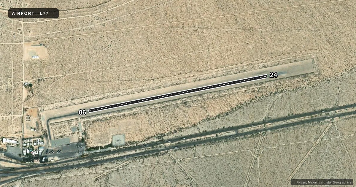
Runways & pattern
Full pagePattern entry · RWY 06
LEFT TRAFFICAirport sketch
Runways drawn to scale from FAA survey coordinates, rendered over satellite imagery. Not for navigation.
Approaches & charts
Services on the field
Fuel grades, oxygen, maintenance, ramp storage and lighting — as declared to the FAA by the airport operator.
Fuel & services
- Fuel
- Not available
- Oxygen (bottled)
- Not available
- Oxygen (bulk)
- Not available
- Airframe repair
- Not available
- Power plant repair
- Not available
Ramp & ground
- Transient storage
- Tie-down
- Landing fee
- No fee published
- Customs
- Not available
- Wind indicator
- Yes
- Segmented circle
- Yes
Fuel & FBOs
Cheapest 100LL and Jet A on the field and nearby. Always confirm with the FBO before taxi.
Airport notes
Surface conditions, obstructions, local procedures, lighting outages and other notes published with each FAA cycle.
General notes
- PILOTS VISIBILITY IS LIMITED TO 1400 FT FROM EITHER END OF RY 06/24.
- FOR CD CTC LOS ANGELES ARTCC AT 661-575-2079.
Runway surface & condition
- 06/24GROSS WEIGHT STRENGTH PRVDD BY ARPT MANAGEMENT 6000 LBS.
Other notes
- ESTABD PRIOR TO 5/15/59.
VFR map & nearby airports
VFR sectional. Tap any ICAO chip to open that airport.
Key facts · L77
Answer card- ICAO
- L77
- Name
- CHIRIACO SUMMIT
- Location
- CHIRIACO SUMMIT, CALIFORNIA
- Elevation
- 1,710.7 ft MSL
- Traffic pattern altitude
- 2,710.7 ft MSL (1,000 AGL)
- Control tower
- Non-towered (use CTAF)
- Total runways
- 1
- Longest runway
- 06/24 · 4,000 ft
- Published ILS approaches
- 0
- Published frequencies
- 1
- Magnetic variation
- 13°
- Current flight rules
- VFR
- Current wind
- 140° at 7 kt
- Favored runway now
- RWY 06
Chiriaco Summit Airport sits in Chiriaco Summit, California. Field elevation is 1,710.7 ft MSL. The airport has one runway, 06/24, which is 4,000 ft long and asphalt. It is an untowered field, so use CTAF 122.9 for self-announce traffic. No ILS approaches are published here.
The published pattern altitude is not listed. Use the standard 1,000 ft AGL pattern for light piston operations unless current guidance says otherwise. Visibility is limited to 1,400 ft from either end of runway 06/24. That matters on short final and during runway checks. The runway has a published gross weight strength of 6,000 lb. Clearance delivery is handled through Los Angeles ARTCC at 661-575-2079.
There are no on-field FBOs listed in the facts. Plan fuel and ground support with the airport operator or by calling the field directly before arrival. For a first-time arrival, the big items are the limited runway-end visibility. The higher desert elevation also means density altitude deserves attention. Check winds and your personal minimums before you go in.