METAR & TAF KCLR
KCLR does not publish a METAR.
Showing the nearest reporting station: KIPL (IMPERIAL COUNTY) · 18.1 NM away. Conditions at KCLR may differ.
METAR · KIPL
Observed 03:53Z
KIPL 270353Z AUTO 15006KT 10SM CLR 36/21 A2976 RMK AO2 SLP078 T03560206
- Wind
- 150° @ 6 kt
- Visibility
- 10 SM
- Temp / Dew
- 36°C / 21°C
- Altimeter
- 29.76 inHg
- Clouds
- CLR
- Density alt
- 2,493 ft
- Ceiling
- Unlimited
- Rules
- VFR
Airport info & contacts
Manager on record, flight service, ARTCC, attendance schedule and pattern altitude — published by the FAA and refreshed every 28 days.
Location
- From city
- 1 NM NW
- VFR sectional
- LOS ANGELES
- Pattern altitude
- 800 ft AGL · 618 ft MSL
- ARTCC
- ZLA · LOS ANGELES
- NOTAM facility
- SAN (NOTAM-D)
Airport manager
- Name
- JESSE LLANAS
- Phone
- 760-348-4147
- Address
- 125 N. PARK AVE., CALIPATRIA CA 92233
Flight service · Hours
- FSS SAN
- SAN DIEGO1-800-WX-BRIEF
- Attendance
- Unattended
Frequencies
Tap any row to copy the frequency to your clipboard.
Runways & pattern
Full pagePattern entry · RWY 08
LEFT TRAFFICRunway end performance
| End | TORA | TODA | ASDA | LDA | VGSI | Approach lights | Obstruction |
|---|---|---|---|---|---|---|---|
| 08 | — | — | — | — | — | — | 15', road, 200' from thr, 0' R of cntrln, slope 0 |
| 26 | — | — | — | — | — | — | 15', road, 460' from thr, 0' R of cntrln, slope 17 |
Declared distances in feet. TORA = takeoff run available, TODA = takeoff distance, ASDA = accelerate-stop, LDA = landing distance.
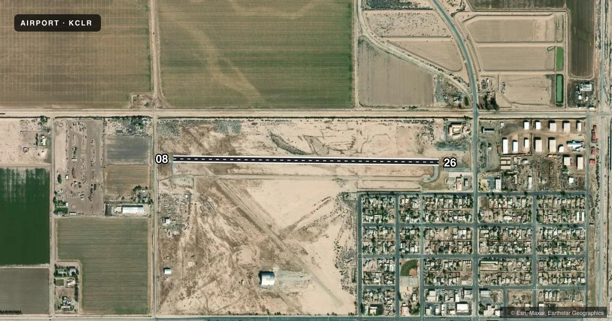
Airport sketch
Runways drawn to scale from FAA survey coordinates, rendered over satellite imagery. Not for navigation.
Approaches & charts
Services on the field
Fuel grades, oxygen, maintenance, ramp storage and lighting — as declared to the FAA by the airport operator.
Fuel & services
- Fuel
- Not available
- Oxygen (bottled)
- Not available
- Oxygen (bulk)
- Not available
- Airframe repair
- Not available
- Power plant repair
- Not available
Ramp & ground
- Transient storage
- Not published
- Landing fee
- No fee published
- Customs
- Not available
- Wind indicator
- Yes
- Segmented circle
- Yes
Fuel & FBOs
Cheapest 100LL and Jet A on the field and nearby. Always confirm with the FBO before taxi.
Airport notes
Surface conditions, obstructions, local procedures, lighting outages and other notes published with each FAA cycle.
General notes
- PARALLEL TWY CLOSED INDEFLY.
- OBSTN PART 77 +184' LGTD FLAG POLE 800' SE OF ARPT.
- FOR CD CTC YUMA CERAP AT 928-269-9569.
Approach & departure obstructions
- 08RWY 08 +3 FT FENCE AT 190 FT.
- 26RWY 26 +3 FT FENCE 150 FT RIGHT, FM 260-500 FT FM THLD.
- 08APPROACH SLOPE 21:1 BASED ON DSPLCD THR
Other notes
- THIS AIRPORT HAS BEEN SURVEYED BY THE NATIONAL GEODETIC SURVEY.
- MANAGERFIRE DEPT OFC IN CALIPATRIA. CELL PHONE 760-791-0296.
VFR map & nearby airports
VFR sectional. Tap any ICAO chip to open that airport.
Key facts · KCLR
Answer card- ICAO
- KCLR
- Name
- CLIFF HATFIELD MEML
- Location
- CALIPATRIA, CALIFORNIA
- Elevation
- -181.8 ft MSL
- Traffic pattern altitude
- 618.2 ft MSL (800 AGL)
- Control tower
- Non-towered (use CTAF)
- Total runways
- 1
- Longest runway
- 08/26 · 3,423 ft
- Published ILS approaches
- 0
- Published frequencies
- 1
- Magnetic variation
- 13°
- Current flight rules
- VFR
- Current wind
- 150° at 6 kt
- Favored runway now
- RWY 08
Cliff Hatfield Meml Airport is in Calipatria, California. The field elevation is -181.8 ft MSL. It has one runway. Runway 08/26 is 3,423 ft long with an asphalt surface. The airport is non-towered. CTAF is 122.9. No ILS approaches are published here.
Pattern altitude is 800 ft AGL. That is 618.2 ft MSL. The runway headings are magnetic 91° and 271°. The airport has no on-field FBOs listed, so verify services before you go. The published remarks also note that the parallel taxiway is closed indefinitely. That matters for ground planning. There is also a 184-foot lighted flag pole about 800 feet southeast of the airport. Runway 08 has a 3-foot fence at 190 feet. Runway 26 has a 3-foot fence 150 feet right from 260 to 500 feet from the threshold.
This is a low-elevation desert field with a published obstacle environment. Use the current FAA Chart Supplement for the latest notes before departure. For clearance delivery, contact Yuma CERAP at 928-269-9569. If you are arriving VFR, expect to self-announce on CTAF and plan for the published pattern altitude. The airport has been surveyed by the National Geodetic Survey.