METAR & TAF KCXL
KCXL does not publish a METAR.
Showing the nearest reporting station: KIPL (IMPERIAL COUNTY) · 10.5 NM away. Conditions at KCXL may differ.
METAR · KIPL
Observed 05:53Z
KIPL 260553Z AUTO 28011KT 10SM CLR 38/11 A2973 RMK AO2 SLP069 T03780111 10472 20378 51018
- Wind
- 280° @ 11 kt
- Visibility
- 10 SM
- Temp / Dew
- 38°C / 11°C
- Altimeter
- 29.73 inHg
- Clouds
- CLR
- Density alt
- 3,003 ft
- Ceiling
- Unlimited
- Rules
- VFR
Airport info & contacts
Manager on record, flight service, ARTCC, attendance schedule and pattern altitude — published by the FAA and refreshed every 28 days.
Location
- From city
- 1 NM W
- VFR sectional
- LOS ANGELES
- ARTCC
- ZLA · LOS ANGELES
- NOTAM facility
- SAN (NOTAM-D)
Airport manager
- Name
- LILIANA FALOMIR
- Phone
- (760) 768-2160
- Address
- 608 HEBER AVENUE, CALEXICO CA 92231
Flight service · Hours
- FSS SAN
- SAN DIEGO1-800-WX-BRIEF
- Attendance
- 0800-1700
Frequencies
Tap any row to copy the frequency to your clipboard.
Runways & pattern
Full pagePattern entry · RWY 26
RIGHT TRAFFICRunway end performance
| End | TORA | TODA | ASDA | LDA | VGSI | Approach lights | Obstruction |
|---|---|---|---|---|---|---|---|
| 08 | — | — | — | — | PAPI 4-box left(3°) | — | 37', pline, 1000' from thr, 300' R of cntrln, slope 21 |
| 26 | — | — | — | — | PAPI 4-box left(3.4°) | — | — |
Declared distances in feet. TORA = takeoff run available, TODA = takeoff distance, ASDA = accelerate-stop, LDA = landing distance.
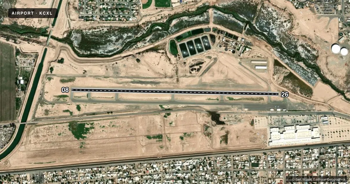
Airport sketch
Runways drawn to scale from FAA survey coordinates, rendered over satellite imagery. Not for navigation.
Approaches & charts
Services on the field
Fuel grades, oxygen, maintenance, ramp storage and lighting — as declared to the FAA by the airport operator.
Fuel & services
- Fuel
- 100LLAA+
- Oxygen (bottled)
- Not available
- Oxygen (bulk)
- Not available
- Airframe repair
- Not available
- Power plant repair
- Not available
- Other services
- AGRI
Ramp & ground
- Transient storage
- Tie-down
- Landing fee
- No fee published
- Customs
- Available
- Beacon schedule
- SS-SR
- Beacon
- White / Green (civil land)(WG)
- Wind indicator
- Lighted
- Segmented circle
- Yes
Fuel & FBOs
Cheapest 100LL and Jet A on the field and nearby. Always confirm with the FBO before taxi.
Airport notes
Surface conditions, obstructions, local procedures, lighting outages and other notes published with each FAA cycle.
General notes
- RY 08/26 - GROUND DROP-OFF ON EAST END OF RY & NORTH OF EAST ACFT PARKING AREA.
- FOR CD CTC YUMA CERAP AT 928-269-9569.
Other notes
- TPA 800' CONVENTIONAL ACFT; 1200' JET ACFT.
- UNICOM MONITORED 0800-1700.
- MANAGERCITY MANAGER, OFFICE IN CALEXICO.
VFR map & nearby airports
VFR sectional. Tap any ICAO chip to open that airport.
Key facts · KCXL
Answer card- ICAO
- KCXL
- Name
- CALEXICO INTL
- Location
- CALEXICO, CALIFORNIA
- Elevation
- 5.7 ft MSL
- Traffic pattern altitude
- 1,005.7 ft MSL (1,000 AGL)
- Control tower
- Non-towered (use CTAF)
- Total runways
- 1
- Longest runway
- 08/26 · 4,683 ft
- Published ILS approaches
- 0
- Published frequencies
- 2
- Magnetic variation
- 13°
- Current flight rules
- VFR
- Current wind
- 280° at 11 kt
- Favored runway now
- RWY 26
Calexico Intl (KCXL) sits in Calexico, California near the U.S.-Mexico border. Field elevation is 5.7 ft MSL. The airport has one runway. Runway 08/26 is 4,683 ft long with an asphalt surface. The field is not towered. CTAF and UNICOM are both 122.8. UNICOM is monitored from 0800 to 1700.
No ILS approaches are published here. Pattern altitude is published as 800 ft AGL for conventional aircraft. Jet traffic uses 1,200 ft AGL. That matters here because the field is very low and the traffic pattern is not the standard 1,000 ft AGL setup you may expect elsewhere.
Calexico International Airport is on the field. It carries 100LL and Jet A. Call the FBO directly at (760) 768-2175 for current services. Published remarks also note ground drop-off on the east end of Runway 08/26 and north of the east aircraft parking area. Plan your taxi and rollout with that in mind. For clearance delivery, contact Yuma Center Radar Approach Control at 928-269-9569. Check the current Chart Supplement for any published noise or curfew restrictions before flying into the field.