METAR & TAF KBWC
KBWC does not publish a METAR.
Showing the nearest reporting station: KIPL (IMPERIAL COUNTY) · 10.0 NM away. Conditions at KBWC may differ.
METAR · KIPL
Observed 00:53Z
KIPL 250053Z AUTO 13012KT 10SM CLR 46/17 A2961 RMK AO2 SLP029 T04610167
- Wind
- 130° @ 12 kt
- Visibility
- 10 SM
- Temp / Dew
- 46°C / 17°C
- Altimeter
- 29.61 inHg
- Clouds
- CLR
- Density alt
- 3,946 ft
- Ceiling
- Unlimited
- Rules
- VFR
Airport info & contacts
Manager on record, flight service, ARTCC, attendance schedule and pattern altitude — published by the FAA and refreshed every 28 days.
Location
- From city
- 1 NM NE
- VFR sectional
- LOS ANGELES
- ARTCC
- ZLA · LOS ANGELES
- NOTAM facility
- SAN (NOTAM-D)
Airport manager
- Name
- ALAN CHAN
- Phone
- 760-587-4122
- Address
- 180 S. WESTERN AVENUE, BRAWLEY CA 92227
Flight service · Hours
- FSS SAN
- SAN DIEGO1-800-WX-BRIEF
- Attendance
- Unattended
Frequencies
Tap any row to copy the frequency to your clipboard.
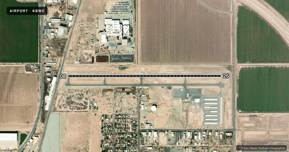
Runways & pattern
Full pagePattern entry · RWY 08
LEFT TRAFFICRunway end performance
| End | TORA | TODA | ASDA | LDA | VGSI | Approach lights | Obstruction |
|---|---|---|---|---|---|---|---|
| 08 | — | — | — | — | PAPI 2-box left(3°) | — | 23', rr, 210' from thr, 0' R of cntrln, slope 0 |
| 26 | — | — | — | — | PAPI 2-box right(3°) | — | — |
Declared distances in feet. TORA = takeoff run available, TODA = takeoff distance, ASDA = accelerate-stop, LDA = landing distance.
Airport sketch
Runways drawn to scale from FAA survey coordinates, rendered over satellite imagery. Not for navigation.
Approaches & charts
Services on the field
Fuel grades, oxygen, maintenance, ramp storage and lighting — as declared to the FAA by the airport operator.
Fuel & services
- Fuel
- 100LLA+
- Oxygen (bottled)
- Not available
- Oxygen (bulk)
- Not available
- Airframe repair
- Major
- Power plant repair
- Major
- Other services
- AGRI,AMB,CHTR,INSTR,RNTL
Ramp & ground
- Transient storage
- Tie-down
- Landing fee
- No fee published
- Customs
- Not available
- Lighting schedule
- SEE RMK
- Beacon schedule
- SS-SR
- Beacon
- White / Green (civil land)(WG)
- Wind indicator
- Lighted
- Segmented circle
- Yes
Fuel & FBOs
Cheapest 100LL and Jet A on the field and nearby. Always confirm with the FBO before taxi.
Airport notes
Surface conditions, obstructions, local procedures, lighting outages and other notes published with each FAA cycle.
General notes
- FOR CD CTC YUMA CERAP AT 928-269-9569.
Lighting notes
- ACTVT REIL RWY 08 & 26; MIRL RWY 08/26; TWY LGTS - CTAF.
Fuel notes
- 100LLFOR FUEL USE CARDLOCK-24/7.
- A+AFTER HRS ON-CALL 760-353-1182.
Approach & departure obstructions
- 08RWY 08 +7 FT FENCE 170 FT FM END OF RY.
- 26RY 26 +15 FT ROAD 115 FT FM RY END +7 FT FENCE 66 FT FM RY END.
- 08RWY 08 APCH RATIO 26:1 TO DSPLCD THR.
- 26APCH RATIO TO DSPLCD THR +15 FT ROAD 510 FT FM DSPLCD THR 34:1.
Other notes
- TPA 800' CONVENTIONAL ACFT; 1200 JET ACFT.
- MANAGERPUBLIC WORKS DEPT OFFICE IN BRAWLEY
VFR map & nearby airports
VFR sectional. Tap any ICAO chip to open that airport.
Key facts · KBWC
Answer card- ICAO
- KBWC
- Name
- BRAWLEY MUNI
- Location
- BRAWLEY, CALIFORNIA
- Elevation
- -127.8 ft MSL
- Traffic pattern altitude
- 872.2 ft MSL (1,000 AGL)
- Control tower
- Non-towered (use CTAF)
- Total runways
- 1
- Longest runway
- 08/26 · 4,166 ft
- Published ILS approaches
- 0
- Published frequencies
- 1
- Magnetic variation
- 13°
- Current flight rules
- VFR
- Current wind
- 130° at 12 kt
- Favored runway now
- RWY 08
Brawley Muni (KBWC) sits in Brawley, California. Field elevation is -127.8 ft MSL. The airport has one runway, 08/26, which is 4,166 ft long and paved asphalt. There is no control tower. CTAF is 122.9. No ILS approaches are published here.
Pattern altitude is not published in the usual FAA format. The Chart Supplement remarks give 800 ft AGL for conventional aircraft and 1,200 ft AGL for jet aircraft. The field also has published lighting. Runway end identifier lights are installed on 08 and 26. Medium intensity runway lights are installed on both runways. Taxiway lights are controlled by the common traffic advisory frequency.
Imperial Flying Service is on the field. It carries 100LL. The remarks also say 100LL is available through a 24-hour cardlock system. After-hours fuel service is available on call. For clearance delivery, contact Yuma Center Radar Approach Control. First-time pilots should pay close attention to the published obstructions near both runway ends. Runway 26 has a road and fence close in. Runway 08 also has a fence near the departure end. This is a low-elevation desert field, so expect density altitude to still matter on hot days even though the airport sits below sea level.