METAR & TAF KTRM
Current METAR
Observed 22:52Z
KTRM 222252Z AUTO 14007KT 10SM CLR 43/12 A2971 RMK AO2 SLP062 T04330122
- Wind
- 140° @ 7 kt
- Visibility
- 10 SM
- Temp / Dew
- 43°C / 12°C
- Altimeter
- 29.71 inHg
- Clouds
- CLR
- Density alt
- 3,479 ft
- Ceiling
- Unlimited
- Rules
- VFR
Airport info & contacts
Manager on record, flight service, ARTCC, attendance schedule and pattern altitude — published by the FAA and refreshed every 28 days.
Location
- From city
- 20 NM SE
- VFR sectional
- LOS ANGELES
- ARTCC
- ZLA · LOS ANGELES
- NOTAM facility
- TRM (NOTAM-D)
Airport manager
- Name
- ANGELA JAMISON
- Phone
- 951-955-9418
- Address
- 4080 LEMON STREET, 14TH FLOOR, RIVERSIDE CA 92501
Flight service · Hours
- FSS RAL
- RIVERSIDE1-800-WX-BRIEF
- Attendance
- 0700-1800
Frequencies
Tap any row to copy the frequency to your clipboard.
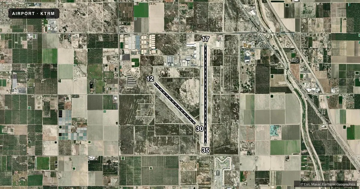
Runways & pattern
Full pagePattern entry · RWY 12
LEFT TRAFFIC| Runway | Heading (°M) | Length | Surface | Traffic |
|---|---|---|---|---|
| 17/35 | 167° / 347° | 8,500 ft | ASPH | Standard L |
| 12/30Favored | 122° / 302° | 4,995 ft | ASPH | Standard L |
Runway end performance
| End | TORA | TODA | ASDA | LDA | VGSI | Approach lights | Obstruction |
|---|---|---|---|---|---|---|---|
| 17 | — | — | — | — | PAPI 4-box left(3°) | — | — |
| 35 | — | — | — | — | PAPI 4-box left(3°) | — | — |
| 12 | — | — | — | — | PAPI 2-box left(3°) | — | — |
| 30 | — | — | — | — | PAPI 2-box left(3°) | — | — |
Declared distances in feet. TORA = takeoff run available, TODA = takeoff distance, ASDA = accelerate-stop, LDA = landing distance.
Airport sketch
Runways drawn to scale from FAA survey coordinates, rendered over satellite imagery. Not for navigation.
Approaches & charts
Services on the field
Fuel grades, oxygen, maintenance, ramp storage and lighting — as declared to the FAA by the airport operator.
Fuel & services
- Fuel
- 100LLA
- Oxygen (bottled)
- HIGH/LOW
- Oxygen (bulk)
- Low pressure
- Airframe repair
- Major
- Power plant repair
- Major
- Other services
- AMB,CHTR
Ramp & ground
- Transient storage
- Tie-down
- Hangar
- Landing fee
- No fee published
- Customs
- Not available
- Lighting schedule
- SEE RMK
- Beacon schedule
- SS-SR
- Beacon
- White / Green (civil land)(WG)
- Wind indicator
- Lighted
- Segmented circle
- Yes
Fuel & FBOs
Cheapest 100LL and Jet A on the field and nearby. Always confirm with the FBO before taxi.
Airport notes
Surface conditions, obstructions, local procedures, lighting outages and other notes published with each FAA cycle.
General notes
- SOFT GND OFF RWY PAVEMENT.
- FOR CD CTC SOCAL APCH AT 800-448-3724.
Lighting notes
- ACTVT REIL RWYS 17 & 35; PAPI RWYS 12, 17, 30 & 35; MIRL RWYS 12/30 & 17/35 - CTAF.
Runway surface & condition
- 17/35200 FT BLAST PADS BOTH ENDS.
Approach & departure obstructions
- 35UNUSBL BYD 8 NM DUE TO TERRAIN.
VFR map & nearby airports
VFR sectional. Tap any ICAO chip to open that airport.
Key facts · KTRM
Answer card- ICAO
- KTRM
- Name
- JACQUELINE COCHRAN RGNL
- Location
- PALM SPRINGS, CALIFORNIA
- Elevation
- -114.4 ft MSL
- Traffic pattern altitude
- 885.6 ft MSL (1,000 AGL)
- Control tower
- Non-towered (use CTAF)
- Total runways
- 2
- Longest runway
- 17/35 · 8,500 ft
- Published ILS approaches
- 0
- Published frequencies
- 5
- Magnetic variation
- 13°
- Current flight rules
- VFR
- Current wind
- 140° at 7 kt
- Favored runway now
- RWY 12
Jacqueline Cochran Rgnl sits in Palm Springs, California. The field elevation is -114.4 ft MSL. It has two asphalt runways. The longest is runway 17/35 at 8,500 ft. Runway 12/30 is 4,995 ft. There is no control tower. Clearance delivery is handled through SoCal Approach. The published contact for clearance delivery is 800-448-3724.
No ILS approaches are published here. Pattern altitude is not published in the facts. Use the standard 1,000 ft AGL for light piston traffic unless the current FAA Chart Supplement says otherwise. Runway lighting is pilot controlled through CTAF. Runway end identifier lights are on 17 and 35. PAPI is published for 12, 17, 30 and 35. Runway 35 is unusable beyond 8 NM because of terrain. Soft ground is present off the pavement. Runway 17/35 also has 200 ft blast pads at both ends.
Three on-field FBOs are listed. Atlantic Aviation carries 100LL and Jet A. Desert Jet carries 100LL, Jet A and Jet A Prist. Thermal Aviation carries 100LL, Jet A and Jet A Prist. For a first-time arrival, pay close attention to the terrain note on runway 35 and the soft ground near the edges. This is a desert field. Runway choice and departure planning matter more than they do at a flat inland airport.