METAR & TAF KSAS
KSAS does not publish a METAR.
Showing the nearest reporting station: KTRM (JACQUELINE COCHRAN RGNL) · 25.4 NM away. Conditions at KSAS may differ.
METAR · KTRM
Observed 22:52Z
KTRM 222252Z AUTO 14007KT 10SM CLR 43/12 A2971 RMK AO2 SLP062 T04330122
- Wind
- 140° @ 7 kt
- Visibility
- 10 SM
- Temp / Dew
- 43°C / 12°C
- Altimeter
- 29.71 inHg
- Clouds
- CLR
- Density alt
- 3,516 ft
- Ceiling
- Unlimited
- Rules
- VFR
Airport info & contacts
Manager on record, flight service, ARTCC, attendance schedule and pattern altitude — published by the FAA and refreshed every 28 days.
Location
- From city
- 1 NM SW
- VFR sectional
- LOS ANGELES
- Pattern altitude
- 800 ft AGL · 716 ft MSL
- ARTCC
- ZLA · LOS ANGELES
- NOTAM facility
- SAN (NOTAM-D)
Airport manager
- Name
- GARY KOONTZ
- Phone
- (909) 429-4200
- Address
- 9890 CHERRY AVENUE, FONTANA CA 92335
Flight service · Hours
- FSS SAN
- SAN DIEGO1-800-WX-BRIEF
- Attendance
- Unattended
Frequencies
Tap any row to copy the frequency to your clipboard.
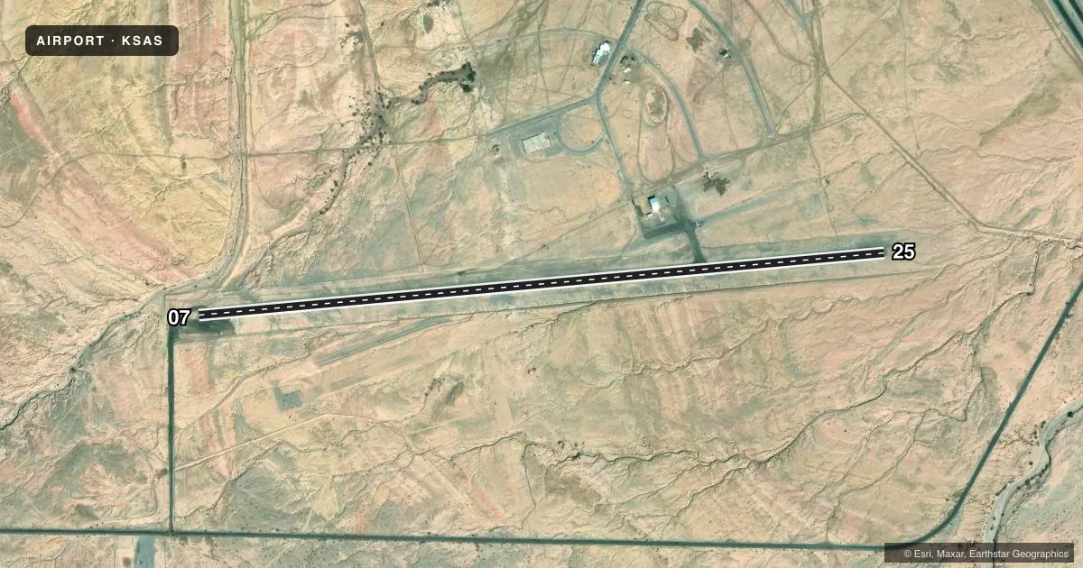
Runways & pattern
Full pagePattern entry · RWY 07
RIGHT TRAFFICAirport sketch
Runways drawn to scale from FAA survey coordinates, rendered over satellite imagery. Not for navigation.
Approaches & charts
Services on the field
Fuel grades, oxygen, maintenance, ramp storage and lighting — as declared to the FAA by the airport operator.
Fuel & services
- Fuel
- Not available
- Oxygen (bottled)
- Not available
- Oxygen (bulk)
- Not available
- Airframe repair
- Not available
- Power plant repair
- Not available
Ramp & ground
- Transient storage
- Tie-down
- Landing fee
- No fee published
- Wind indicator
- Yes
- Segmented circle
- Yes
Fuel & FBOs
Cheapest 100LL and Jet A on the field and nearby. Always confirm with the FBO before taxi.
Airport notes
Surface conditions, obstructions, local procedures, lighting outages and other notes published with each FAA cycle.
General notes
- LOOSE GRVL INVOF PARKING AREA.
- OCCASIONAL ULTRALIGHT ACTIVITY ON WEEKENDS.
- FOR CD CTC YUMA CERAP AT 928-269-9569.
Approach & departure obstructions
- 07RY 07 AND RY 25 WHITE THLD BARS ARE ONLY MARKINGS ON RY.
VFR map & nearby airports
VFR sectional. Tap any ICAO chip to open that airport.
Key facts · KSAS
Answer card- ICAO
- KSAS
- Name
- SALTON SEA
- Location
- SALTON CITY, CALIFORNIA
- Elevation
- -84 ft MSL
- Traffic pattern altitude
- 716 ft MSL (800 AGL)
- Control tower
- Non-towered (use CTAF)
- Total runways
- 1
- Longest runway
- 07/25 · 5,000 ft
- Published ILS approaches
- 0
- Published frequencies
- 1
- Magnetic variation
- 13°
- Current flight rules
- VFR
- Current wind
- 140° at 7 kt
- Favored runway now
- RWY 07
Salton Sea Airport sits at Salton City in California. Field elevation is -84 ft MSL. The airport has one runway. Runway 07/25 is 5,000 ft long and has a gravel surface. The field is not towered. CTAF is 122.9. Pattern altitude is 800 ft AGL, which is 716 ft MSL. No ILS approaches are published here.
For clearance delivery, contact Yuma Center Radar Approach Control at 928-269-9569. Loose gravel is reported near the parking area. Occasional ultralight activity happens on weekends, so keep your scan active in the pattern. The only runway markings noted are white threshold bars at both ends. That is useful to know if you are coming in here for the first time.
There are no on-field FBOs listed in the facts. Plan on verifying services with the airport operator or the FBO directly by phone before arrival. The airport sits below sea level. The field elevation is unusual even though the runway is only 5,000 ft. Use the current chart and pay attention to the gravel surface, the weekend traffic mix and the published pattern altitude before you go.