METAR & TAF L90
L90 does not publish a METAR.
Showing the nearest reporting station: KTRM (JACQUELINE COCHRAN RGNL) · 28.8 NM away. Conditions at L90 may differ.
METAR · KTRM
Observed 22:52Z
KTRM 222252Z AUTO 14007KT 10SM CLR 43/12 A2971 RMK AO2 SLP062 T04330122
- Wind
- 140° @ 7 kt
- Visibility
- 10 SM
- Temp / Dew
- 43°C / 12°C
- Altimeter
- 29.71 inHg
- Clouds
- CLR
- Density alt
- 3,819 ft
- Ceiling
- Unlimited
- Rules
- VFR
Airport info & contacts
Manager on record, flight service, ARTCC, attendance schedule and pattern altitude — published by the FAA and refreshed every 28 days.
Location
- From city
- 0 NM N
- VFR sectional
- LOS ANGELES
- Pattern altitude
- 800 ft AGL · 960 ft MSL
- ARTCC
- ZLA · LOS ANGELES
- NOTAM facility
- SAN (NOTAM-D)
Airport manager
- Name
- MEADOW CHASE
- Phone
- 760-788-3366
- Address
- SAN DIEGO COUNTY AIRPORTS, 1960 JOE CROSSON DRIVE, EL CAJON CA 92020-1236
Flight service · Hours
- FSS SAN
- SAN DIEGO1-800-WX-BRIEF
- Attendance
- Unattended
Frequencies
Tap any row to copy the frequency to your clipboard.
Runways & pattern
Full pagePattern entry · RWY 13
LEFT TRAFFIC| Runway | Heading (°M) | Length | Surface | Traffic |
|---|---|---|---|---|
| 13/31Favored | 133° / 313° | 4,210 ft | DIRT | 31 R |
| 09/27 | 93° / 273° | 2,330 ft | DIRT | 09 R |
Runway end performance
| End | TORA | TODA | ASDA | LDA | VGSI | Approach lights | Obstruction |
|---|---|---|---|---|---|---|---|
| 13 | — | — | — | — | — | — | 60', hill, 2000' from thr, 0' R of cntrln, slope 33 |
| 31 | — | — | — | — | — | — | 19', road, 420' from thr, 0' R of cntrln, slope 22 |
| 09 | — | — | — | — | — | — | 50', hill, 800' from thr, 0' R of cntrln, slope 16 |
| 27 | — | — | — | — | — | — | 77', hill, 3000' from thr, 0' R of cntrln, slope 38 |
Declared distances in feet. TORA = takeoff run available, TODA = takeoff distance, ASDA = accelerate-stop, LDA = landing distance.
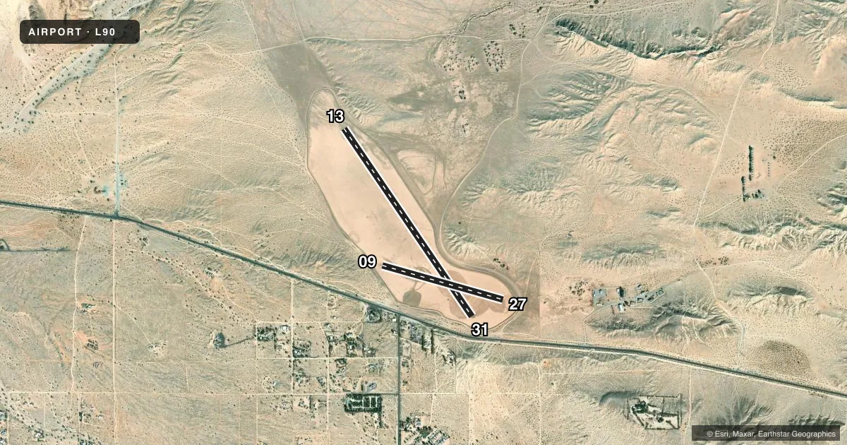
Airport sketch
Runways drawn to scale from FAA survey coordinates, rendered over satellite imagery. Not for navigation.
Approaches & charts
Services on the field
Fuel grades, oxygen, maintenance, ramp storage and lighting — as declared to the FAA by the airport operator.
Fuel & services
- Fuel
- Not available
- Oxygen (bottled)
- Not available
- Oxygen (bulk)
- Not available
- Airframe repair
- Not available
- Power plant repair
- Not available
Ramp & ground
- Transient storage
- Tie-down
- Landing fee
- No fee published
- Customs
- Not available
- Wind indicator
- Yes
- Segmented circle
- Yes
Fuel & FBOs
Cheapest 100LL and Jet A on the field and nearby. Always confirm with the FBO before taxi.
Airport notes
Surface conditions, obstructions, local procedures, lighting outages and other notes published with each FAA cycle.
General notes
- FLD UNUSABLE WHEN WET.
- OBSTN TO FAR PART 77, HILLS SURROUND ARPT.
- RWY 09/27 AND RWY 13/31 THLDS MARKED BY WHITE PAVING BLOCKS.
- CTN FOR OCNL UNAUTHORIZED OFF ROAD VEHICLES ON AND IN VCNTY OF RWYS AND TWYS.
- ALL RY INTERSECTIONS MARKED BY WHITE PAVING BLOCKS.
- BE ALERT FOR HIGH SPD MIL TILT ROTOR AND ULTRALIGHT OPS ON AND IN VCNTY OF ARPT.
- ALL RWYS CLSD SS-SR, NOT LGTD.
- ALL RDO EQUIPPED ACFT MUST SELF-ANNOUNCE ON CTAF PRIOR TO LDG OR DEP.
- PPR FOR ALL MIL ACFT; CTC AMGR.
- FOR CD CTC YUMA CERAP AT 928-269-9569.
Other notes
- MANAGERAMGRS OFFICE AT BORREGO VALLEY AIRPORT.
- 13/31NORTH 300 FT SOFT
VFR map & nearby airports
VFR sectional. Tap any ICAO chip to open that airport.
Key facts · L90
Answer card- ICAO
- L90
- Name
- OCOTILLO
- Location
- OCOTILLO WELLS, CALIFORNIA
- Elevation
- 160 ft MSL
- Traffic pattern altitude
- 960 ft MSL (800 AGL)
- Control tower
- Non-towered (use CTAF)
- Total runways
- 2
- Longest runway
- 13/31 · 4,210 ft
- Published ILS approaches
- 0
- Published frequencies
- 1
- Magnetic variation
- 13°
- Current flight rules
- VFR
- Current wind
- 140° at 7 kt
- Favored runway now
- RWY 13
Ocotillo Airport sits in Ocotillo Wells, California. Field elevation is 160 ft MSL. It has two dirt runways. The longest is runway 13/31 at 4,210 ft. Runway 09/27 is 2,330 ft. There is no control tower. CTAF is 122.9.
No ILS approaches are published here. Pattern altitude is 800 ft AGL, which is 960 ft MSL. That matters here because the field is surrounded by hills. The published remarks also say the airport is unusable when wet. All runways are closed from sunset to sunrise. They are not lighted.
Runway thresholds and intersections are marked by white paving blocks. The north 300 ft of runway 13/31 is soft. There are also reports of occasional unauthorized off-road vehicles on or near the runways and taxiways. Expect to self-announce on CTAF before landing or departure. Be alert for high speed military tilt rotor traffic and ultralight operations in the area. For clearance delivery, contact Yuma CERAP. No on-field FBOs are listed, so verify services with the airport operator before you go. The airport manager's office is at Borrego Valley Airport.