METAR & TAF L78
L78 does not publish a METAR.
Showing the nearest reporting station: KIPL (IMPERIAL COUNTY) · 32.4 NM away. Conditions at L78 may differ.
METAR · KIPL
Observed 23:53Z
KIPL 262353Z AUTO 23003KT 10SM CLR 39/18 A2976 RMK AO2 SLP078 60000 T03890183 10394 20344 56028
- Wind
- 230° @ 3 kt
- Visibility
- 10 SM
- Temp / Dew
- 39°C / 18°C
- Altimeter
- 29.76 inHg
- Clouds
- CLR
- Density alt
- 6,605 ft
- Ceiling
- Unlimited
- Rules
- VFR
Airport info & contacts
Manager on record, flight service, ARTCC, attendance schedule and pattern altitude — published by the FAA and refreshed every 28 days.
Location
- From city
- 1 NM E
- VFR sectional
- LOS ANGELES
- ARTCC
- ZLA · LOS ANGELES
- NOTAM facility
- SAN (NOTAM-D)
Airport manager
- Name
- CATHE JOHNSON
- Phone
- 619-956-4800
- Address
- SAN DIEGO COUNTY AIRPORTS, CROSSON DRIVE, EL CAJON CA 92020
Flight service · Hours
- FSS SAN
- SAN DIEGO1-800-WX-BRIEF
- Attendance
- Unattended
Frequencies
Tap any row to copy the frequency to your clipboard.
Runways & pattern
Full pagePattern entry · RWY 25
RIGHT TRAFFICRunway end performance
| End | TORA | TODA | ASDA | LDA | VGSI | Approach lights | Obstruction |
|---|---|---|---|---|---|---|---|
| 25 | — | — | — | — | — | — | 480', hill, 5000' from thr, 0' R of cntrln, slope 10 |
Declared distances in feet. TORA = takeoff run available, TODA = takeoff distance, ASDA = accelerate-stop, LDA = landing distance.
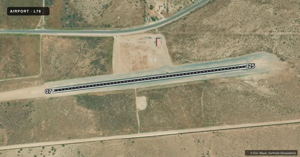
Airport sketch
Runways drawn to scale from FAA survey coordinates, rendered over satellite imagery. Not for navigation.
Approaches & charts
Services on the field
Fuel grades, oxygen, maintenance, ramp storage and lighting — as declared to the FAA by the airport operator.
Fuel & services
- Fuel
- Not available
- Oxygen (bottled)
- Not available
- Oxygen (bulk)
- Not available
- Airframe repair
- Not available
- Power plant repair
- Not available
- Other services
- TOW
Ramp & ground
- Transient storage
- Tie-down
- Landing fee
- No fee published
- Customs
- Not available
- Wind indicator
- Yes
- Segmented circle
- Yes
Fuel & FBOs
Cheapest 100LL and Jet A on the field and nearby. Always confirm with the FBO before taxi.
Airport notes
Surface conditions, obstructions, local procedures, lighting outages and other notes published with each FAA cycle.
General notes
- WIND PMTG, RCMD LAND RWY 07 AND DEPART RWY 25 DUE TO 480 FT HILL 1 MI E OF AP.
- FRQ GLD ACT DRG WKENDS, PWRD ACFT BE ALERT FOR GLD TFC LAUNCHING FRM FLD AND OPERG ON AND IN VCNTY OF AP, SFC TO 18000 FT MSL.
- RAPIDLY RISING TRRN ALL QUADS.
- OCNL WILDLIFE ON AND IN VCNTY OF AP.
- CONTIGUOUS ADIZ IN VCNTY AND ALONG INTL BDRY, LCTD APRXLY 615 FT S OF RWY 07-25.
- ALL ACFT AVOID OVERFLIGHT US/MEXICAN BDR WO AUTH.
- NOISE ABATEMENT; AVOID OVERFLYING RESIDENTIAL COMMUNITY 1/2 MI W.
- RCMD RWY TO RAMP TRSN, ASPH TO SOFT DIRT, AT TWY STUB MIDFIELD, ALL OTHER AREAS ASPH TO GRVL.
- HEL SKID/RUN-ON LDG AND AUTO-ROTATIONS PROHIBITED.
- RDO EQUIPPPED ACFT SHALL SELF-ANNC ON CTAF PRIOR TO LDG OR TKOF.
- PIN TO OBTAIN VEHICLE ACES TO ARPT, CALL 619-956-4800.
- PPR ALL MIL ACFT CTC AMGR.
- FOR CD CTC LOS ANGELES ARTCC AT 661-575-2079.
Runway surface & condition
- 07/25CLSD SS-SR, NOT LGTD.
Approach & departure obstructions
- 25INTL BDRY TO S.
VFR map & nearby airports
VFR sectional. Tap any ICAO chip to open that airport.
Key facts · L78
Answer card- ICAO
- L78
- Name
- JACUMBA
- Location
- JACUMBA, CALIFORNIA
- Elevation
- 2,844 ft MSL
- Traffic pattern altitude
- 3,844 ft MSL (1,000 AGL)
- Control tower
- Non-towered (use CTAF)
- Total runways
- 1
- Longest runway
- 07/25 · 2,562 ft
- Published ILS approaches
- 0
- Published frequencies
- 1
- Magnetic variation
- 13°
- Current flight rules
- VFR
- Current wind
- 230° at 3 kt
- Favored runway now
- RWY 25
Jacumba Airport (L78) sits in Jacumba, California near the international boundary in far southeastern California. Field elevation is 2,844 ft MSL. The airport has one runway, 07/25, which is 2,562 ft long and asphalt. There is no control tower. CTAF is 122.9. No ILS approaches are published.
Pattern altitude is not published. Use standard 1,000 ft AGL unless the current FAA Chart Supplement says otherwise. That puts the light aircraft pattern at 3,844 ft MSL. The field has no on-field FBOs listed, so plan on self-sufficiency and verify services before you go. Published remarks call out rapidly rising terrain in all quadrants. They also note a 480-foot hill one mile east of the airport, so wind and performance matter here. The FAA remarks recommend landing runway 07 and departing runway 25 when wind allows. Runway 07/25 is closed from sunset to sunrise and is not lighted.
First-time pilots should also plan for glider activity on weekends, wildlife on and near the airport and noise abatement that avoids overflying the residential area west of the field. The international boundary is south of runway 25. For vehicle access, call the number in the Chart Supplement before arrival. For current operating details, check the FAA Chart Supplement or call the airport operator directly.