METAR & TAF KSEE
Current METAR
Observed 04:15Z
KSEE 270415Z AUTO 22003KT 10SM CLR 24/20 A2992 RMK AO2
- Wind
- 220° @ 3 kt
- Visibility
- 10 SM
- Temp / Dew
- 24°C / 20°C
- Altimeter
- 29.92 inHg
- Clouds
- CLR
- Density alt
- 1,561 ft
- Ceiling
- Unlimited
- Rules
- VFR
Airport info & contacts
Manager on record, flight service, ARTCC, attendance schedule and pattern altitude — published by the FAA and refreshed every 28 days.
Location
- From city
- 10 NM NE
- VFR sectional
- LOS ANGELES
- ARTCC
- ZLA · LOS ANGELES
- NOTAM facility
- SEE (NOTAM-D)
Airport manager
- Name
- CLIFFORD REINHART
- Phone
- 619-956-4800
- Address
- 1960 JOE CROSSON DR, EL CAJON CA 92020-1236
Flight service · Hours
- FSS SAN
- SAN DIEGO1-800-WX-BRIEF
- Attendance
- 0700-2100
Frequencies
Tap any row to copy the frequency to your clipboard.
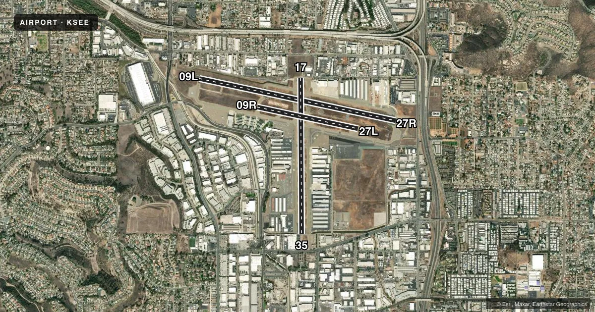
Runways & pattern
Full pagePattern entry · RWY 17
LEFT TRAFFIC| Runway | Heading (°M) | Length | Surface | Traffic |
|---|---|---|---|---|
| 09L/27R | 89° / 269° | 5,342 ft | ASPH | 27R R |
| 17/35Favored | 166° / 346° | 4,145 ft | ASPH | Standard L |
| 09R/27L | 89° / 269° | 2,738 ft | ASPH | Standard L |
Runway end performance
| End | TORA | TODA | ASDA | LDA | VGSI | Approach lights | Obstruction |
|---|---|---|---|---|---|---|---|
| 09L | — | — | — | — | PAPI 4-box right(3.75°) | — | 87', tree, 580' from thr, 275' R of cntrln, slope 4 |
| 27R | — | — | — | — | PAPI 4-box left(4.5°) | — | 37', road, 585' from thr, 250' R of cntrln, slope 10 |
| 17 | — | — | — | — | PAPI 4-box left(3.7°) | — | 15', bldg, 201' from thr, 125' R of cntrln, slope 0 |
| 35 | — | — | — | — | PAPI 4-box left(3.5°) | — | 30', pole, 510' from thr, 40' R of cntrln, slope 10 |
Declared distances in feet. TORA = takeoff run available, TODA = takeoff distance, ASDA = accelerate-stop, LDA = landing distance.
Airport sketch
Runways drawn to scale from FAA survey coordinates, rendered over satellite imagery. Not for navigation.
Approaches & charts
ILS · 1
Services on the field
Fuel grades, oxygen, maintenance, ramp storage and lighting — as declared to the FAA by the airport operator.
Fuel & services
- Fuel
- 100LLA
- Oxygen (bottled)
- HIGH/LOW
- Oxygen (bulk)
- HIGH/LOW
- Airframe repair
- Major
- Power plant repair
- Major
- Other services
- AFRT,AMB,AVNCS,CHTR,INSTR,RNTL,SALES,SURV
Ramp & ground
- Transient storage
- Tie-down
- Landing fee
- No fee published
- Lighting schedule
- SEE RMK
- Beacon schedule
- SS-SR
- Beacon
- White / Green (civil land)(WG)
- Wind indicator
- Lighted
- Segmented circle
- No
Fuel & FBOs
Cheapest 100LL and Jet A on the field and nearby. Always confirm with the FBO before taxi.
Airport notes
Surface conditions, obstructions, local procedures, lighting outages and other notes published with each FAA cycle.
General notes
- RWY 17-35 TPA 1188 (800) SR-SS, 1388 (1000) SS-SR.
- RWY 27R CNTRLN IN CLOSE ALNMT WITH TRRN, USE OF LOC/DME HIGHLY RCMDD.
- FORMATION FLT AVBL AS TFC PERMITS, LTD TO NO MORE THAN 3 ACFT PER FORMATION.
- RWY 27R TPA 1588 (1200) RIGHT TFC SR-SS; TPA 1388 (1000) LEFT TFC SS-SR DUE TO 893 FT AGL MOUNTAIN 2.1 NM ENE OF ARPT. RWY 27L 1388 (1000) LEFT TFC SR-SS.
- W TRNT RAMP AND PTNS OF TWY DELTA BTN D2 AND W TSTN RAMP NOT VISIBLE FROM ATCT.
- WHEN TWR CLSD, ACFT MUST SELF-ANNOUNCE ON CTAF PRIOR TO LDG OR DEP.
- COYOTES AND BIRDS OCCASIONALLY ON AND IN VCNTY OF ARPT.
- SIMULATED ENG FAILURES PROHIBITED OVER RESIDENTIAL AREAS.
- PPR FOR ALL MIL ACFT, AND ALL MIL/CIV VFR LOW APCHS BLO 1000 FT AGL CTC ARPT OPS 619-956-4800.
- NOISE ABATEMENT PROCS IN EFFECT. RWY 17 PREFERRED NOISE ABATEMENT DEP WHEN ATCT CLSD. TGL AND JET DEPS STRONGLY DISCOURAGED 2200-0700. NOISE SENSITIVE AREAS ALL QUADS. NOISE ABATEMENT PATTERN INFO AVBL AT SDCOUNTYAIRPORTS.COM OR CTC ARPT OPS 619-956-4800. COPTER PIONEER NOISE ABATEMENT PATTERN ALT 700 FT MSL; DEP S FR RWY 35 NRS, CROSSWIND BTN BRADLEY AND VERNON WAY, DOWNWIND AT WING AVE, TURN BASE LEG TO FLY OVR E/W TAXI LINE ON E TSNT RAMP, DO NOT OVRFLY TWY D, THEN VIA RWY 17 TO RWY 35 NRS. RMN S OF TWY B4 DUE TO XNG GND TFC. DO NOT OVRFLY PRKD OR TAX ACFT.
- RWYS 9L/27R & 9R/27L HEL SKID/RUN-ON LDG PROHIBITED.
- FOR CD WHEN ATCT CLSD CTC SOCAL APCH AT 800-448-3724.
Lighting notes
- WHEN ATCT CLSD ACTVT REIL RWY 27R; PAPI RWYS 09L, 27R, 17 & 35; MIRL RWY 09L/27R & RWY 17/35 - CTAF.
Fuel notes
- 100LLFOR FUEL SVC OR ASSISTANCE DRG BUS HRS, CTC (619) 449-0611, (619) 448-5991, OR (619) 981-5000. 100LL SELF SVC AVBL 24 HRS.
Runway surface & condition
- 09R/27LRWY UNLGTD; CLSD SS-SR.
- 17/35RWY 17 END LGTS NON-STD, SPREAD LESS THAN RWY PAVEMENT WIDTH.
Approach & departure obstructions
- 17RWY 17 +8 FT FENCE AT 30 FT FM RWY END, 85 FT LEFT.
- 35RWY 35 UNLIT 8 FT FENCE 1 FT SOUTH OF RWY END; +20 FT TREES AT 100-200 FT FM RWY END 130 FT LEFT.
- 27RPAPI UNUSBL BYD 6 DEGS RIGHT OF CRS.
- 35UNUSBL BYD 4 DEGS LEFT OF CNTRLN.
- 17RWY 17 APCH RATIO 20:1 TO DSPLCD THLD.
- 27RRWY 27R APCH RATIO 30:1 TO DSPLCD THR.
- 35RWY 35 APCH RATIO TO DSPLCD THLD OVER +30 FT POLE 1203 FT FM DSPLCD THLD 40 FT LEFT 40:1.
Other notes
- THIS AIRPORT HAS BEEN SURVEYED BY THE NATIONAL GEODETIC SURVEY.
- MANAGERARPT OPNS, 619-956-4800.
VFR map & nearby airports
VFR sectional. Tap any ICAO chip to open that airport.
Key facts · KSEE
Answer card- ICAO
- KSEE
- Name
- GILLESPIE FLD
- Location
- SAN DIEGO/EL CAJON, CALIFORNIA
- Elevation
- 387.5 ft MSL
- Traffic pattern altitude
- 1,387.5 ft MSL (1,000 AGL)
- Control tower
- Towered · 0700-2100
- Total runways
- 3
- Longest runway
- 09L/27R · 5,342 ft
- Published ILS approaches
- 1
- Published frequencies
- 15
- Magnetic variation
- 13°
- Current flight rules
- VFR
- Current wind
- 220° at 3 kt
- Favored runway now
- RWY 17
Gillespie Field sits in San Diego County near El Cajon, California. Field elevation is 387.5 ft MSL. The airport has 3 asphalt runways. The longest is 5,342 ft on 09L/27R. The tower is open 0700 to 2100. One ILS approach is published for runway 27R. Pattern altitude is not published in the facts, so verify the current Chart Supplement before you fly. For light piston traffic, standard pattern altitude is often 1,000 ft AGL. Use the published value if it differs.
This is a busy field with noise abatement in effect. Noise sensitive areas are in all quadrants. Touch-and-go and jet departures are strongly discouraged between 2200 and 0700. Runway 17 is the preferred noise abatement departure runway when the tower is closed. The west transient ramp and part of taxiway Delta between D2 and the west transient ramp are not visible from the tower, so taxi with care. Coyotes and birds are also reported in the area.
On the field, Golden State Aviation, Circle Air Group and High Performance Aircraft are listed. Golden State Aviation and Circle Air Group carry 100LL, Jet A and Jet A Prist. High Performance Aircraft carries Jet A and Jet A Prist. 100LL self-service is available 24 hours. Runway 27R deserves extra attention. The approach is closely aligned with terrain, so localizer and DME use is highly recommended.