METAR & TAF L18
Current METAR
Observed 05:15Z
KL18 270515Z AUTO 00000KT 10SM CLR 20/20 A2997 RMK AO2
- Wind
- 000° @ 0 kt
- Visibility
- 10 SM
- Temp / Dew
- 20°C / 20°C
- Altimeter
- 29.97 inHg
- Clouds
- CLR
- Density alt
- 1,420 ft
- Ceiling
- Unlimited
- Rules
- VFR
Airport info & contacts
Manager on record, flight service, ARTCC, attendance schedule and pattern altitude — published by the FAA and refreshed every 28 days.
Location
- From city
- 2 NM S
- VFR sectional
- LOS ANGELES
- ARTCC
- ZLA · LOS ANGELES
- NOTAM facility
- L18 (NOTAM-D)
Airport manager
- Name
- MEADOW CHASE
- Phone
- 760-788-3366
- Address
- 2155 SOUTH MISSION ROAD, FALLBROOK CA 92028
Flight service · Hours
- FSS SAN
- SAN DIEGO1-800-WX-BRIEF
- Attendance
- MON-FRI · 0900-1400
Frequencies
Tap any row to copy the frequency to your clipboard.
Runways & pattern
Full pagePattern entry · RWY 18
LEFT TRAFFICRunway end performance
| End | TORA | TODA | ASDA | LDA | VGSI | Approach lights | Obstruction |
|---|---|---|---|---|---|---|---|
| 18 | — | — | — | — | PSIL(4°) | — | — |
Declared distances in feet. TORA = takeoff run available, TODA = takeoff distance, ASDA = accelerate-stop, LDA = landing distance.
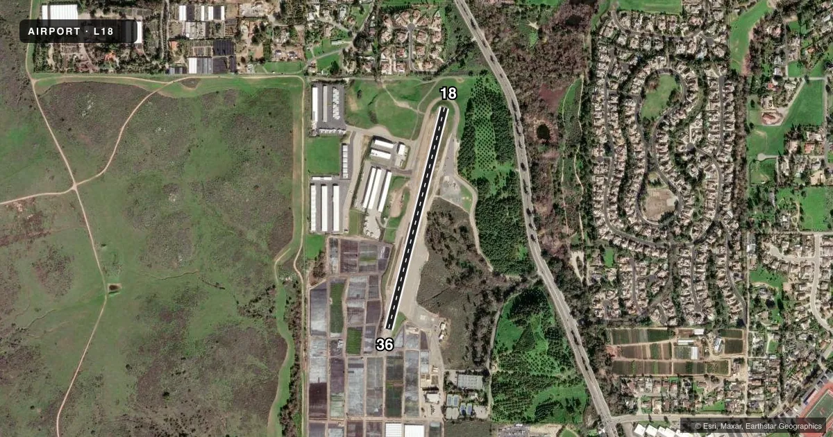
Airport sketch
Runways drawn to scale from FAA survey coordinates, rendered over satellite imagery. Not for navigation.
Approaches & charts
Services on the field
Fuel grades, oxygen, maintenance, ramp storage and lighting — as declared to the FAA by the airport operator.
Fuel & services
- Fuel
- 100LL
- Oxygen (bottled)
- HIGH/LOW
- Oxygen (bulk)
- Not available
- Airframe repair
- Major
- Power plant repair
- Major
- Other services
- INSTR,RNTL,SALES
Ramp & ground
- Transient storage
- Tie-down
- Landing fee
- No fee published
- Customs
- Not available
- Lighting schedule
- SEE RMK
- Beacon schedule
- SS-SR
- Beacon
- White / Green (civil land)(WG)
- Wind indicator
- Yes
- Segmented circle
- Yes
Fuel & FBOs
Cheapest 100LL and Jet A on the field and nearby. Always confirm with the FBO before taxi.
Airport notes
Surface conditions, obstructions, local procedures, lighting outages and other notes published with each FAA cycle.
General notes
- NO SAFETY AREA AVBL DUE TO ABRUPT DROP-OFF EACH END OF RWY.
- NOISE ABATEMENT: TKOFS CLIMB STRAIGHT AHEAD TO 1200 FT MSL. RWY 18 TURN CROSSWIND WHEN ABEAM WATER TANK 1.1 MI ESE OF RWY. RWY 18 EXTEND DOWNWIND LEG TO ALLOW 1/3 MILE FINAL APCH. FLY DOWNWIND EAST OF HIGH SCHOOL.
- PPR FOR ALL ACFT OVER 12000 LBS AND ALL MIL ACFT, CTC AMGR.
- TWY HOLD BARS NON -STD DIST FM RY EDGE.
- MIL BASE SW, FRQ MIL HELS IN VICINITY OF ARPT.
- CONC HELIPAD CLOSED TO UNAUTHORIZED AIRCRAFT.
- AP ADMIN BLDG EAST SIDE OF RWY; FUELING AREA WEST OF AFLD.
- PART 77 OBSTRUCTION, +15 FT HILL 100 FT E OF RWY 18 CNTRLN.
- ROTORCRAFT FUEL UNAVBL. RCMDD HEL TFC PAT APCH AND DEP AT 492 FT AGL TO AND FROM EAST AT MID RWY. HEL TGL RSTRD TO RWY.
- HOVERS, SKID LANDINGS, AND AUTO-ROTATIONS PROHIBITED.
- RWY 18 CALM WIND RWY
- TRAN PRKG LCTD ON SE CORNER OF AFLD.
- OCNL COYOTE ON OR IN THE VICINITY OF RWY AND TWY.
- ACFT SHALL SELF-ANNOUNCE ON CTAF PRIOR TO LDG OR TKOF.
- FOR CD CTC SOCAL APCH AT 800-448-3724.
Lighting notes
- MIRL RWY 18/36 MED INTST ONLY AVBL. ACTVT MIRL RWY 18/36 & TWY LGTS - CTAF (5 CLICKS ON).
Fuel notes
- 100LLSELF-SERVICE FUEL AVBL 24 HRS.
Runway surface & condition
- H1RSTD TO PUBLIC SAFETY ACFT.
Other notes
- TPA - 1708(1000) FIXED WING, 1200(492) HEL.
VFR map & nearby airports
VFR sectional. Tap any ICAO chip to open that airport.
Key facts · L18
Answer card- ICAO
- L18
- Name
- FALLBROOK COMMUNITY AIRPARK
- Location
- FALLBROOK, CALIFORNIA
- Elevation
- 710.9 ft MSL
- Traffic pattern altitude
- 1,710.9 ft MSL (1,000 AGL)
- Control tower
- Non-towered (use CTAF)
- Total runways
- 1
- Longest runway
- 18/36 · 2,150 ft
- Published ILS approaches
- 0
- Published frequencies
- 5
- Magnetic variation
- 13°
- Current flight rules
- VFR
- Current wind
- 000° at 0 kt
- Favored runway now
- –
Fallbrook Community Airpark sits in Fallbrook, California. Field elevation is 710.9 ft MSL. It has one runway, 18/36, which is 2,150 ft long. The airport is non-towered. Runway 18 is the calm wind runway. No ILS approaches are published here.
For fixed-wing traffic, the published pattern altitude is 1,708 ft MSL. That is 1,000 ft AGL. Helicopter pattern altitude is 1,200 ft MSL. That is 492 ft AGL. The field uses CTAF 123.05. SoCal Approach handles clearance delivery on 127.3 or 323.0, with the same pair listed for approach and departure. AHM is on the field. It carries 100LL. Call (760) 431-7670 for current services.
There are a few operational items worth having in mind before arrival. Noise abatement calls for takeoffs to climb straight ahead to 1,200 ft MSL. Runway 18 departures then turn crosswind abeam the water tank 1.1 miles east-southeast of the runway. The downwind for runway 18 is extended, with the leg flown east of the high school. Medium intensity runway lights are available. Key the CTAF five times to activate runway and taxiway lights. The runway has no safety area because of abrupt drop-off at both ends. Occasional coyote activity has been reported on or near the runway and taxiway.