METAR & TAF KMYF
Current METAR
Observed 11:53Z
KMYF 271153Z AUTO 00000KT 7SM OVC010 22/20 A2992 RMK AO2 SLP128 T02220200 10222 20222 55005
- Wind
- 000° @ 0 kt
- Visibility
- 7 SM
- Temp / Dew
- 22°C / 20°C
- Altimeter
- 29.92 inHg
- Clouds
- OVC
- Density alt
- 1,370 ft
- Ceiling
- 1,000 ft AGL
- Rules
- MVFR
Airport info & contacts
Manager on record, flight service, ARTCC, attendance schedule and pattern altitude — published by the FAA and refreshed every 28 days.
Location
- From city
- 6 NM N
- VFR sectional
- LOS ANGELES
- ARTCC
- ZLA · LOS ANGELES
- NOTAM facility
- MYF (NOTAM-D)
Airport manager
- Name
- CHARLES BROADBENT
- Phone
- 858-573-1430
- Address
- 3750 JOHN J MONTGOMERY DR, SAN DIEGO CA 92123
Flight service · Hours
- FSS SAN
- SAN DIEGO1-800-WX-BRIEF
- Attendance
- M-S · 0700-1800
Frequencies
Tap any row to copy the frequency to your clipboard.
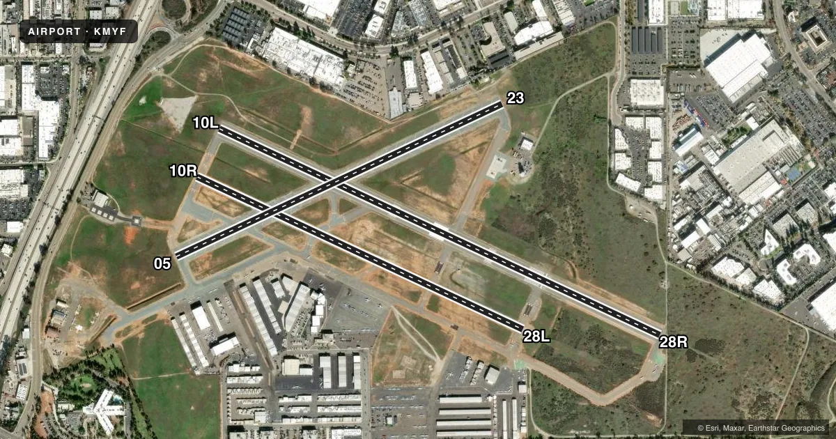
Runways & pattern
Full pagePattern entry · RWY 10L
LEFT TRAFFIC| Runway | Heading (°M) | Length | Surface | Traffic |
|---|---|---|---|---|
| 10L/28R | 101° / 281° | 4,598 ft | ASPH | 28R R |
| 10R/28L | 101° / 281° | 3,401 ft | ASPH | 10R R |
| 05/23 | 51° / 231° | 3,400 ft | ASPH-TRTD | Standard L |
Runway end performance
| End | TORA | TODA | ASDA | LDA | VGSI | Approach lights | Obstruction |
|---|---|---|---|---|---|---|---|
| 10L | — | — | — | — | PAPI 4-box left(3.4°) | — | — |
| 28R | — | — | — | — | PAPI 4-box right(3°) | MALSR | — |
Declared distances in feet. TORA = takeoff run available, TODA = takeoff distance, ASDA = accelerate-stop, LDA = landing distance.
Airport sketch
Runways drawn to scale from FAA survey coordinates, rendered over satellite imagery. Not for navigation.
Approaches & charts
ILS · 1
Services on the field
Fuel grades, oxygen, maintenance, ramp storage and lighting — as declared to the FAA by the airport operator.
Fuel & services
- Fuel
- 100LLAA+UL94
- Oxygen (bottled)
- Low pressure
- Oxygen (bulk)
- High pressure
- Airframe repair
- Major
- Power plant repair
- Major
- Other services
- AFRT,AMB,AVNCS,CARGO,CHTR,INSTR,RNTL,SALES,SURV
Ramp & ground
- Transient storage
- Tie-down
- Landing fee
- No fee published
- Customs
- Not available
- Lighting schedule
- SEE RMK
- Beacon schedule
- SS-SR
- Beacon
- White / Green (civil land)(WG)
- Wind indicator
- Lighted
- Segmented circle
- Yes
Fuel & FBOs
Cheapest 100LL and Jet A on the field and nearby. Always confirm with the FBO before taxi.
Airport notes
Surface conditions, obstructions, local procedures, lighting outages and other notes published with each FAA cycle.
General notes
- BE ALERT TO MILITARY JET ACFT INVOF OF ARPT & 4.7 NM NW OF ARPT BEARING 312 INVOF MISSION BAY VORTAC.
- EXTRM NOISE SENSITIVE AREAS W & S OF ARPT. NOISE MONITORING IN EFFECT. MAX NOISE LMT 2330-0630 70 DB OVER RESIDENTIAL AREAS. MAX NOISE LMT 0630-2330 88 DB.
- BE ALERT BIRDS ON AND INVOF ARPT; COYOTE ACTIVITY ON RYS & TWYS.
- BE ALERT HVY ACFT ACTIVITY IN THE VICINITY OF LAKE MURRAY & MT SOLEDAD. PILOTS ARE URGED TO BE VIGILANT FOR OTHER ACFT IN THESE AREAS & TO CTC THE TWR EARLY ENOUGH FOR TIMELY TFC ADVISORIES IF PROCEDING EAST BOUND ADVISE TWR OF DESTINATION ARPT.
- SIMULATED ENGINE FAILURES ARE PROHIBITED OVER RESIDENTIAL AREAS. NO JET TOUCH AND GO OPNS.
- FOR NOISE ABATEMENT REGULATIONS CONTACT THE NOISE ABATEMENT OFFICE AT 858-573-1436.
- ACFT WITH HIGH NOISE LEVELS ARE REQUESTED TO USE RY 10L/28R
- LDG FEES FOR OPS BY NON-BASED PART 91 AND PART 135 CERTIFIED ACFT.
- TWY K RSTRD TO WINGSPAN NO GREATER THAN 58 FT.
- NO ACFT OVR 20,000 LBS ON TWY J RSTRD BY FBO.
- FOR CD WHEN ATCT CLSD CTC SOCAL APCH AT 800-448-3724.
- TXL E NON-STD, ACFT WITH WINGSPAN GTR THAN 35.5 FT. USE CAUTION.
- PPR FOR MIL AND CIV HELS OVER 6000 LBS MAX TKOF WT LDG AT MID-PORT; CTC ARPT MGR.
- RWY 23 USED AS RWY EXIT FOR RWY 28R.
Lighting notes
- ATC CTL. WHEN ATCT CLSD ACTVT PAPI RWY 10L & 28R; MALSR RWY 28R - CTAF, MIRL RWY 10L/28R OPER CONSLY.
Approach & departure obstructions
- 28R50:1 APCH SLOPE TO DSPLCD THLD.
Other notes
- TPA RWYS 10R/28L, 10L/28R, AND 05/23 - MULTI ENG/TURBO PWRD 1600 FT; SNGL ENG 1000 FT.
VFR map & nearby airports
VFR sectional. Tap any ICAO chip to open that airport.
Key facts · KMYF
Answer card- ICAO
- KMYF
- Name
- MONTGOMERY-GIBBS EXEC
- Location
- SAN DIEGO, CALIFORNIA
- Elevation
- 427.3 ft MSL
- Traffic pattern altitude
- 1,427.3 ft MSL (1,000 AGL)
- Control tower
- Towered · 0600-2100
- Total runways
- 3
- Longest runway
- 10L/28R · 4,598 ft
- Published ILS approaches
- 1
- Published frequencies
- 20
- Magnetic variation
- 14°
- Current flight rules
- MVFR
- Current wind
- 000° at 0 kt
- Favored runway now
- –
Montgomery-Gibbs Exec is in San Diego, California. Field elevation is 427.3 ft MSL. The airport has 3 asphalt runways. The longest is 10L/28R at 4,598 ft. The field is towered from 0600 to 2100. One ILS is published for runway 28R.
For pattern work, the published traffic pattern altitude is 1,600 ft MSL for multi-engine and turbo powered aircraft. It is 1,000 ft MSL for single engine aircraft. The airport sits in a busy part of San Diego airspace. Expect heavy traffic near Lake Murray and Mount Soledad. Military jet traffic is also a factor in the area. Noise monitoring is in effect. West and south of the airport are extreme noise sensitive areas. If you need the current noise rules, call the noise abatement office before arrival.
Crownair Aviation is on the field. It carries AVGAS 100LL, JET A, JET A PRIST and UL94. Coast Air Center is also on the field. It carries AVGAS 100LL, JET A and JET A PRIST. When the tower is closed, use the published lighting procedures for 10L and 28R. Watch for birds and coyote activity on and near the airport. Taxiway K is limited to aircraft with a wingspan of 58 ft or less. Runway 23 is used as an exit for runway 28R.