METAR & TAF KCRQ
Current METAR
Observed 03:53Z
KCRQ 270353Z 25003KT 10SM CLR 22/20 A2992 RMK AO2 SLP129 T02220200
- Wind
- 250° @ 3 kt
- Visibility
- 10 SM
- Temp / Dew
- 22°C / 20°C
- Altimeter
- 29.92 inHg
- Clouds
- CLR
- Density alt
- 1,250 ft
- Ceiling
- Unlimited
- Rules
- VFR
Airport info & contacts
Manager on record, flight service, ARTCC, attendance schedule and pattern altitude — published by the FAA and refreshed every 28 days.
Location
- From city
- 3 NM SE
- VFR sectional
- LOS ANGELES
- ARTCC
- ZLA · LOS ANGELES
- NOTAM facility
- CRQ (NOTAM-D)
Airport manager
- Name
- JOHN OTTO
- Phone
- 760-431-4646
- Address
- 2192 PALOMAR AIRPORT ROAD, CARLSBAD CA 92011-4409
Flight service · Hours
- FSS SAN
- SAN DIEGO1-800-WX-BRIEF
- Attendance
- 0700-2200
Frequencies
Tap any row to copy the frequency to your clipboard.
Runways & pattern
Full pagePattern entry · RWY 24
RIGHT TRAFFICRunway end performance
| End | TORA | TODA | ASDA | LDA | VGSI | Approach lights | Obstruction |
|---|---|---|---|---|---|---|---|
| 06 | 4,897' | 4,897' | 4,897' | 4,600' | PAPI 4-box left(3°) | — | — |
| 24 | 4,897' | 4,897' | 4,897' | 4,897' | PAPI 4-box left(3.2°) | MALSR | — |
Declared distances in feet. TORA = takeoff run available, TODA = takeoff distance, ASDA = accelerate-stop, LDA = landing distance.
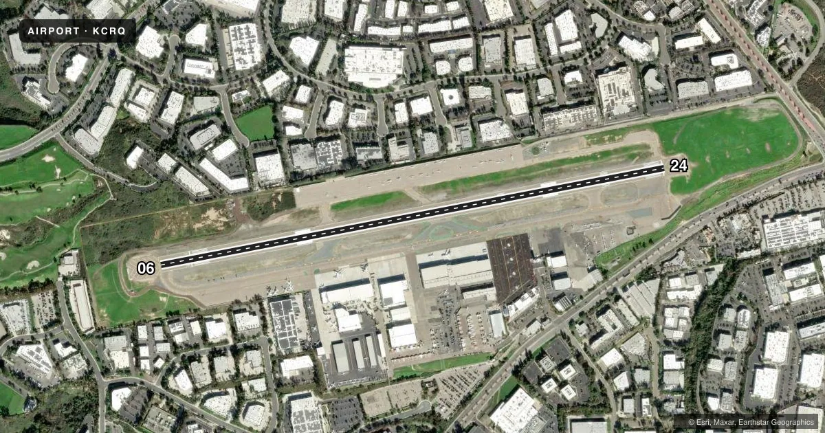
Airport sketch
Runways drawn to scale from FAA survey coordinates, rendered over satellite imagery. Not for navigation.
Approaches & charts
ILS · 1
Services on the field
Fuel grades, oxygen, maintenance, ramp storage and lighting — as declared to the FAA by the airport operator.
Fuel & services
- Fuel
- 100LLA
- Oxygen (bottled)
- HIGH/LOW
- Oxygen (bulk)
- Not available
- Airframe repair
- Major
- Power plant repair
- Major
- Other services
- AFRT,AMB,AVNCS,CHTR,INSTR,RNTL,SALES
Ramp & ground
- Transient storage
- Tie-down
- Landing fee
- Yes
- Customs
- Not available
- Lighting schedule
- SEE RMK
- Beacon schedule
- SS-SR
- Beacon
- White / Green (civil land)(WG)
- Wind indicator
- No
- Segmented circle
- Yes
Fuel & FBOs
Cheapest 100LL and Jet A on the field and nearby. Always confirm with the FBO before taxi.
Airport notes
Surface conditions, obstructions, local procedures, lighting outages and other notes published with each FAA cycle.
General notes
- ARPT HAS NOISE ABATEMENT PROCEDURES CONTACT AMGR 760-431-4646.
- MULTIPLE APCHS BY LARGE ACFT (INCLUDING LARGE HEL) NOT AUTHORIZED.
- NO JET ACFT TRNG DUE TO NOISE ABATEMENT AND TFC CONGESTION.
- EXTENSIVE BIRD ACTIVITY IN VICINITY ESPECIALLY IN SPRING.
- RWY 24 IS CALM WIND RWY.
- POWER LINES 2 MILES W & SW.
- VOLUNTARY CURFEW: JETS 2200-0700 LCL, PROPS 0000-0600 LCL, EMERG, LIFEGUARD, AND LAW ENFORCEMENT EXCEPTED.
- REQUEST JETS FLY THE ILS APPROACH.
- LTD TRANSIENT TIE DOWN SPACE ON PUBLIC RAMP.
- PPR FOR ALL MILITARY ACFT CALL AMGR (760) 431-4646.
- RWY 24 HARD TO SEE 2 HRS PRIOR TO SS; DO NOT MISTAKE TWY A AS THE RWY.
- NORTH SIDE RAMP LIMITED TO 12,500 LBS .
- ALL ACFT MULT PRACTICE APCHS AND LNDGS DISCOURAGED 2200-0700 LCL.
- RY 6/24 SOUTH VFR TFC PATTERN CLSD 2200-0700 LCL.
- WHEN TWR CLSD ACFT MUST SELF-ANNOUNCE ON CTAF PRIOR TO LDG OR TKOF.
- TSNT PRKG LTD TO SML SNGL AND TWIN ENG ACFT WITH WINGSPANS UNDER 38 FT.
- USE CAUTION REG THERMAL PLUMES IN THE VCNTY OF POWER PLANT APRXLY 2.7 NM WNW OF ARPT.
- NO JET ACFT PRKG ALLOWED IN TSNT PRKG.
- FOR CD WHEN ATCT CLSD CTC SOCAL APCH AT 800-448-3724.
Lighting notes
- WHEN ATCT CLSD ACTVT HIRL RWY 06/24, PAPI RWYS 06 & 24, MALSR RWY 24 - CTAF.
Runway surface & condition
- 06/24PCR VALUE: 454/F/C/X/T
Approach & departure obstructions
- H1STANDARD HELIPORT MARKINGS.
Other notes
- THIS AIRPORT HAS BEEN SURVEYED BY THE NATIONAL GEODETIC SURVEY.
- CLOSED TO AIR CARRIER OPNS WITH MORE THAN 9 PASSENGER SEATS FM 2230 TO 0600 EXCEPT BY PPR CALL AMGR 760-431-4646.
- PPR ONLY - NO MIL TRNG - CONTRACT MILITARY ONLY.
- TPA 672 AGL HELICOPTERS; 1172 AGL SMALL ACFT; 1672 AGL LARGE ACFT.
- US CUSTOMS USER FEE ARPT, CTC 877-848-7766.
VFR map & nearby airports
VFR sectional. Tap any ICAO chip to open that airport.
Key facts · KCRQ
Answer card- ICAO
- KCRQ
- Name
- MC CLELLAN-PALOMAR
- Location
- CARLSBAD, CALIFORNIA
- Elevation
- 330.5 ft MSL
- Traffic pattern altitude
- 1,330.5 ft MSL (1,000 AGL)
- Control tower
- Towered · 0700-2200
- Total runways
- 1
- Longest runway
- 06/24 · 4,897 ft
- Published ILS approaches
- 1
- Published frequencies
- 11
- Magnetic variation
- 14°
- Current flight rules
- VFR
- Current wind
- 250° at 3 kt
- Favored runway now
- RWY 24
Mc Clellan-Palomar Airport is in Carlsbad, California. Field elevation is 330.5 ft MSL. The airport has one asphalt runway, 06/24, which is 4,897 ft long. The tower is open daily from 0700 to 2200. One ILS approach is published for runway 24. Traffic pattern altitude is not published for light piston aircraft in the facts block, so use the standard 1,000 ft AGL unless the current FAA Chart Supplement says otherwise. The published pattern altitudes are 672 ft AGL for helicopters, 1172 ft AGL for small aircraft and 1672 ft AGL for large aircraft.
Three on-field FBOs are listed. Western Aviation carries 100LL, Jet A and Jet A Prist. Carlsbad Jet Center carries 100LL, Jet A and Jet A Prist. Atlantic Aviation carries 100LL and Jet A. When the tower is closed, self-announce on CTAF before landing or takeoff. For clearance delivery after hours, contact SoCal Approach. The airport also has published noise abatement procedures. Check those before you go.
A first-time pilot should pay attention to the voluntary curfew, which runs from 2200 to 0700 for jets. Propeller aircraft are restricted from 0000 to 0600. Transient parking is limited to small single and twin engine aircraft with wingspans under 38 ft. There is also a caution about thermal plumes near the power plant about 2.7 NM west-northwest of the field. When the tower is closed, runway 24 lighting and the MALSR can be activated on CTAF.