METAR & TAF KOKB
Current METAR
Observed 10:52Z
KOKB 271052Z AUTO 00000KT 7SM OVC010 22/20 A2991 RMK AO2 SLP127 T02220200
- Wind
- 000° @ 0 kt
- Visibility
- 7 SM
- Temp / Dew
- 22°C / 20°C
- Altimeter
- 29.91 inHg
- Clouds
- OVC
- Density alt
- 887 ft
- Ceiling
- 1,000 ft AGL
- Rules
- MVFR
Airport info & contacts
Manager on record, flight service, ARTCC, attendance schedule and pattern altitude — published by the FAA and refreshed every 28 days.
Location
- From city
- 2 NM NE
- VFR sectional
- LOS ANGELES
- ARTCC
- ZLA · LOS ANGELES
- NOTAM facility
- OKB (NOTAM-D)
Airport manager
- Name
- ANDREW WIGNOT
- Phone
- (760) 901-4260
- Address
- 480 AIRPORT ROAD, SUITE 715, OCEANSIDE CA 92058
Flight service · Hours
- FSS SAN
- SAN DIEGO1-800-WX-BRIEF
- Attendance
- 0900-1700
Frequencies
Tap any row to copy the frequency to your clipboard.
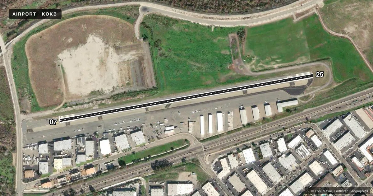
Runways & pattern
Full pagePattern entry · RWY 07
LEFT TRAFFICRunway end performance
| End | TORA | TODA | ASDA | LDA | VGSI | Approach lights | Obstruction |
|---|---|---|---|---|---|---|---|
| 07 | — | — | — | — | — | — | 15', road, 420' from thr, 125' R of cntrln, slope 15 |
| 25 | — | — | — | — | — | — | 210', hill, 5300' from thr, 0' R of cntrln, slope 24 |
Declared distances in feet. TORA = takeoff run available, TODA = takeoff distance, ASDA = accelerate-stop, LDA = landing distance.
Airport sketch
Runways drawn to scale from FAA survey coordinates, rendered over satellite imagery. Not for navigation.
Approaches & charts
Services on the field
Fuel grades, oxygen, maintenance, ramp storage and lighting — as declared to the FAA by the airport operator.
Fuel & services
- Fuel
- 100LLA
- Oxygen (bottled)
- Not available
- Oxygen (bulk)
- Not available
- Airframe repair
- Minor
- Power plant repair
- Major
- Other services
- AMB,INSTR,PAJA,RNTL
Ramp & ground
- Transient storage
- Tie-down
- Landing fee
- No fee published
- Customs
- Not available
- Lighting schedule
- SEE RMK
- Beacon schedule
- SS-SR
- Beacon
- White / Green (civil land)(WG)
- Wind indicator
- Lighted
- Segmented circle
- Yes
Fuel & FBOs
Cheapest 100LL and Jet A on the field and nearby. Always confirm with the FBO before taxi.
Airport notes
Surface conditions, obstructions, local procedures, lighting outages and other notes published with each FAA cycle.
General notes
- FENCE & ROAD WITHIN PRIMARY SFC NORTH SIDE.
- MTS W, NW, SW RWY 07 UP TO 280 FT MSL.
- UNLGTD MT APRX 160 FT MSL IN APCH ZONE AT 3500 FT FROM W END OF PVMT RWY 07.
- NOISE ABATEMENT IN EFCT: FLW RIVERBED ALL THE WAY TO COAST PRIOR TO MAKING ANY TURNS. DO NOT FLY OVER ANY HOUSES ALG RIVER BANKS. NO EARLY TURNOUTS PRIOR TO THE OCEAN. SKYDIVING OPS IN EFCT SR-SS DLY. PRCHT LNDG NORTH SIDE OF RWY BTW DOWNWIND AND RWY; NO EFCT ON ACFT TKOF/LNDG THAT FLW TFC PAT. USE CTN WHILE IN THE PAT.
- DO NOT CONFUSE ROAD SOUTH OF ARPT WITH THE RWY.
- BIRDS ON AND INVOF ARPT.
- FOR CD CTC SOCAL APCH AT 800-448-3724.
- LEFT TFC TO RWY 25 PROHIBITED FOR NOISE ABATEMENT.
Lighting notes
- MIRL RWY 07/25 PRESET LOW INTST; TO INCR INTST ACTVT - CTAF.
Fuel notes
- 100LLFUEL AVBL 24 HRS 100LL SELF SVC, FULL SVC 0900-1630; JET A 0900-1700.
Approach & departure obstructions
- 078 FT FENCE, ROAD, AND 8+ FT TFC SIGNAL AT 345 FT.
Other notes
- ALL TFC PAT ESTAB TO NORTH.
VFR map & nearby airports
VFR sectional. Tap any ICAO chip to open that airport.
Key facts · KOKB
Answer card- ICAO
- KOKB
- Name
- BOB MAXWELL MEML AIRFIELD
- Location
- OCEANSIDE, CALIFORNIA
- Elevation
- 28 ft MSL
- Traffic pattern altitude
- 1,028 ft MSL (1,000 AGL)
- Control tower
- Non-towered (use CTAF)
- Total runways
- 1
- Longest runway
- 07/25 · 2,712 ft
- Published ILS approaches
- 0
- Published frequencies
- 6
- Magnetic variation
- 13°
- Current flight rules
- MVFR
- Current wind
- 000° at 0 kt
- Favored runway now
- –
Bob Maxwell Meml Airfield sits in Oceanside, California. Field elevation is 28 ft MSL. The airport has one runway. Runway 07/25 is 2,712 ft long with asphalt pavement. There is no control tower. No ILS approaches are published here. Pattern altitude is not published, so use the standard 1,000 ft AGL for light piston operations unless the current FAA Chart Supplement says otherwise.
KDG Aviation is on the field. It carries 100LL and Jet A. 100LL is available 24 hours as self-serve. Full service is listed from 0900 to 1630. Jet A is listed from 0900 to 1700. This is a busy pattern airport with skydiving activity from sunrise to sunset. Traffic pattern work is established to the north. Left traffic to runway 25 is prohibited for noise abatement. The published noise path follows the riverbed all the way to the coast before any turns. Do not cut early over the houses along the river banks.
There are also obstacles and nearby terrain to plan around. A road, fence and traffic signal sit close to the runway 07 end. Mountains rise west, northwest and southwest of runway 07. A small unlighted mountain is also noted in the approach zone. For clearance delivery, contact SoCal Approach. Check the current Chart Supplement before you go for any updates on pattern, lighting, or local restrictions.