METAR & TAF KHMT
Current METAR
Observed 09:55Z
KHMT 270955Z AUTO 00000KT 10SM CLR 22/15 A2997 RMK AO2
- Wind
- 000° @ 0 kt
- Visibility
- 10 SM
- Temp / Dew
- 22°C / 15°C
- Altimeter
- 29.97 inHg
- Clouds
- CLR
- Density alt
- 2,656 ft
- Ceiling
- Unlimited
- Rules
- VFR
Airport info & contacts
Manager on record, flight service, ARTCC, attendance schedule and pattern altitude — published by the FAA and refreshed every 28 days.
Location
- From city
- 3 NM SW
- VFR sectional
- LOS ANGELES
- ARTCC
- ZLA · LOS ANGELES
- NOTAM facility
- RAL (NOTAM-D)
Airport manager
- Name
- ANGELA JAMISON
- Phone
- 951-955-9418
- Address
- 4080 LEMON STREET, 14TH FLOOR, RIVERSIDE CA 92501
Flight service · Hours
- FSS RAL
- RIVERSIDE1-800-WX-BRIEF
- Attendance
- DALGT
Frequencies
Tap any row to copy the frequency to your clipboard.
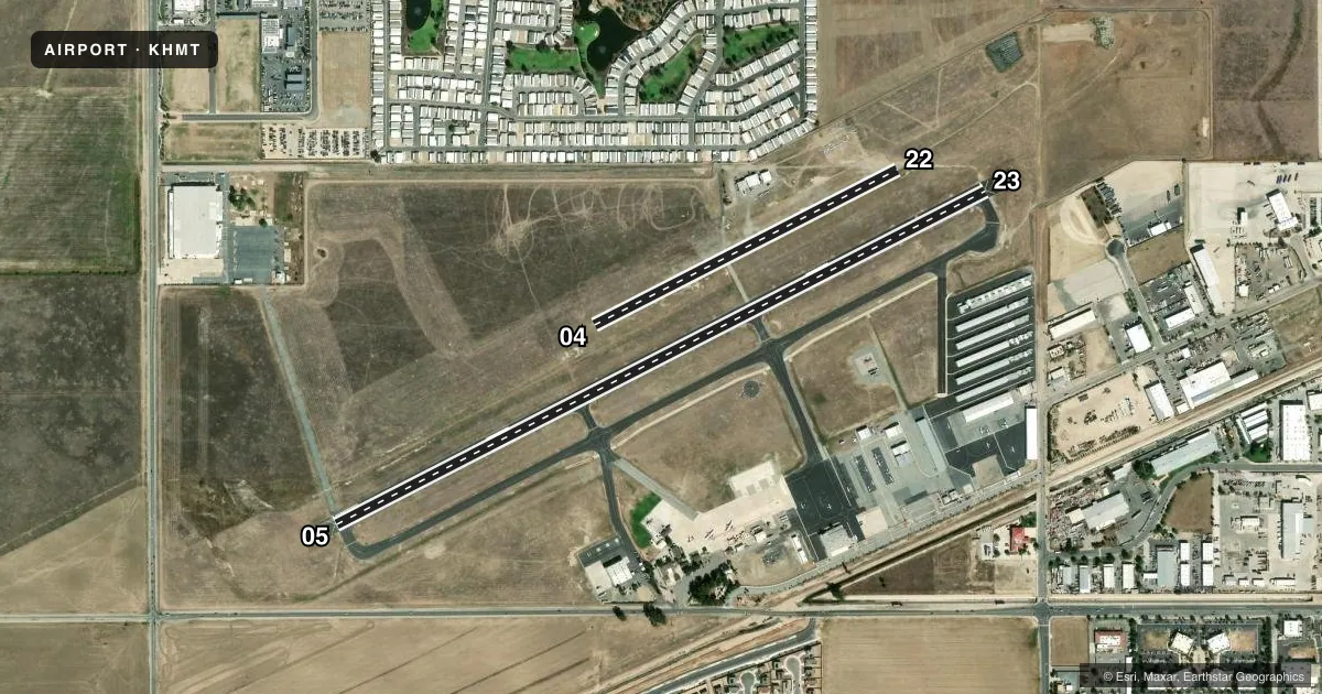
Runways & pattern
Full pagePattern entry · RWY 05
RIGHT TRAFFIC| Runway | Heading (°M) | Length | Surface | Traffic |
|---|---|---|---|---|
| 05/23 | 50° / 230° | 4,315 ft | ASPH | 05 R |
| 04/22 | 50° / 230° | 2,014 ft | ASPH | 22 R |
Runway end performance
| End | TORA | TODA | ASDA | LDA | VGSI | Approach lights | Obstruction |
|---|---|---|---|---|---|---|---|
| 23 | — | — | — | — | PAPI 2-box left(3°) | — | — |
Declared distances in feet. TORA = takeoff run available, TODA = takeoff distance, ASDA = accelerate-stop, LDA = landing distance.
Airport sketch
Runways drawn to scale from FAA survey coordinates, rendered over satellite imagery. Not for navigation.
Approaches & charts
Services on the field
Fuel grades, oxygen, maintenance, ramp storage and lighting — as declared to the FAA by the airport operator.
Fuel & services
- Fuel
- 100LLA
- Oxygen (bottled)
- Not available
- Oxygen (bulk)
- Not available
- Airframe repair
- Major
- Power plant repair
- Major
- Other services
- AMB,GLD,INSTR,RNTL,TOW
Ramp & ground
- Transient storage
- Tie-down
- Landing fee
- No fee published
- Customs
- Not available
- Lighting schedule
- SEE RMK
- Beacon schedule
- SS-SR
- Beacon
- White / Green (civil land)(WG)
- Wind indicator
- Lighted
- Segmented circle
- Yes
Fuel & FBOs
Cheapest 100LL and Jet A on the field and nearby. Always confirm with the FBO before taxi.
Airport notes
Surface conditions, obstructions, local procedures, lighting outages and other notes published with each FAA cycle.
General notes
- AIR TANKER ACTIVITY MAY-NOV; FOREST SVC FIRE FIGHTING ACFT FREQUENTLY FLY THE CONVENTIONAL RECTANGULAR PAT WITH FOUR 90 DEG CLEARING TURNS ENTERING THE DOWN WIND LEG ABEAM MIDPOINT OF RY.
- WATCH FOR USFS FIRE FIGHTING ACFT.
- GLIDER, ULTRALIGHT ACT NORTH SIDE OF ARPT.
- FOR CD CTC SOCAL APCH AT 800-448-3724.
Lighting notes
- ACTVT MIRL RY 05/23 & TWY LGTS - CTAF.
VFR map & nearby airports
VFR sectional. Tap any ICAO chip to open that airport.
Key facts · KHMT
Answer card- ICAO
- KHMT
- Name
- HEMET-RYAN
- Location
- HEMET, CALIFORNIA
- Elevation
- 1,514.8 ft MSL
- Traffic pattern altitude
- 2,514.8 ft MSL (1,000 AGL)
- Control tower
- Non-towered (use CTAF)
- Total runways
- 2
- Longest runway
- 05/23 · 4,315 ft
- Published ILS approaches
- 0
- Published frequencies
- 4
- Magnetic variation
- 13°
- Current flight rules
- VFR
- Current wind
- 000° at 0 kt
- Favored runway now
- –
Hemet-Ryan is in Hemet, California. Field elevation is 1,514.8 ft MSL. The airport has two asphalt runways. The longest is 4,315 ft. There is no control tower. No ILS approaches are published here. Pattern altitude is not published. Use the standard 1,000 ft AGL pattern for light piston traffic unless local procedures or ATC say otherwise.
Hemet-Ryan Aviation is on the field. It carries 100LL and Jet A. Call the FBO at (951) 925-7618 for current service details before you go. CTAF is 123.0. UNICOM is 123.0. Medium intensity runway lights on runway 05/23 and taxiway lights are activated by the CTAF.
This field sits in a busy firefighting environment. Air tanker activity occurs from May through November. Forest Service aircraft may fly a conventional rectangular pattern with four 90 degree clearing turns. Watch for United States Forest Service firefighting aircraft. Glider and ultralight activity is on the north side of the airport. For clearance delivery, contact SoCal Approach at 800-448-3724. If you are planning a first visit, brief the traffic mix. Brief the non-towered pattern. Brief the longer 05/23 runway before arrival.