METAR & TAF KIPL
Current METAR
Observed 23:53Z
KIPL 262353Z AUTO 23003KT 10SM CLR 39/18 A2976 RMK AO2 SLP078 60000 T03890183 10394 20344 56028
- Wind
- 230° @ 3 kt
- Visibility
- 10 SM
- Temp / Dew
- 39°C / 18°C
- Altimeter
- 29.76 inHg
- Clouds
- CLR
- Density alt
- 3,012 ft
- Ceiling
- Unlimited
- Rules
- VFR
Airport info & contacts
Manager on record, flight service, ARTCC, attendance schedule and pattern altitude — published by the FAA and refreshed every 28 days.
Location
- From city
- 1 NM S
- VFR sectional
- PHOENIX
- ARTCC
- ZLA · LOS ANGELES
- NOTAM facility
- IPL (NOTAM-D)
Airport manager
- Name
- MARLYNN LOPEZ
- Phone
- 760-996-2109
- Address
- 155 S. 11TH STREET, EL CENTRO CA 92243
Flight service · Hours
- FSS SAN
- SAN DIEGO1-800-WX-BRIEF
- Attendance
- 0700-1630
Frequencies
Tap any row to copy the frequency to your clipboard.
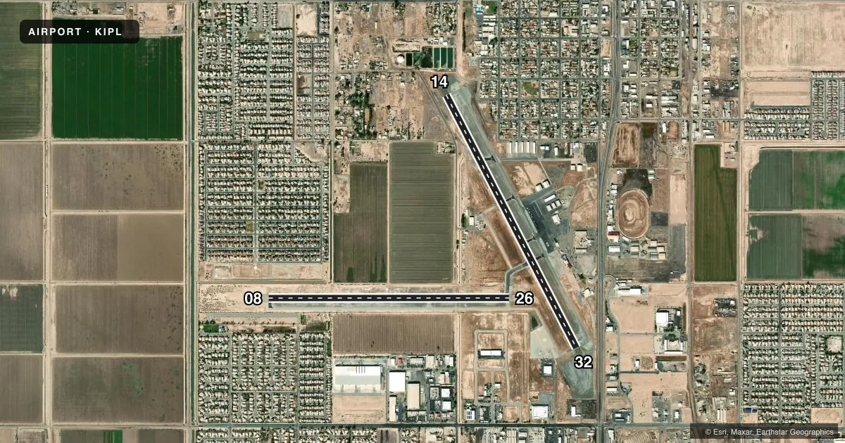
Runways & pattern
Full pagePattern entry · RWY 26
RIGHT TRAFFIC| Runway | Heading (°M) | Length | Surface | Traffic |
|---|---|---|---|---|
| 14/32 | 143° / 323° | 5,308 ft | ASPH | 32 R |
| 08/26Favored | 80° / 260° | 4,501 ft | ASPH | 26 R |
Runway end performance
| End | TORA | TODA | ASDA | LDA | VGSI | Approach lights | Obstruction |
|---|---|---|---|---|---|---|---|
| 14 | 5,308' | 5,308' | 5,308' | 5,308' | PAPI 4-box left(3°) | — | 9', fence, 425' from thr, 130' R of cntrln, slope 25 |
| 32 | 5,308' | 5,308' | 5,308' | 5,308' | PAPI 4-box left(3°) | — | 15', road, 600' from thr, 150' R of cntrln, slope 26 |
| 08 | 4,501' | 4,501' | 4,501' | 4,501' | PAPI 4-box left(3°) | — | 59', pline, 1600' from thr, 0' R of cntrln, slope 23 |
| 26 | 4,501' | 4,501' | 4,501' | 4,501' | PAPI 4-box left(3°) | — | 32', pole, 1575' from thr, 250' R of cntrln, slope 42 |
Declared distances in feet. TORA = takeoff run available, TODA = takeoff distance, ASDA = accelerate-stop, LDA = landing distance.
Airport sketch
Runways drawn to scale from FAA survey coordinates, rendered over satellite imagery. Not for navigation.
Approaches & charts
Services on the field
Fuel grades, oxygen, maintenance, ramp storage and lighting — as declared to the FAA by the airport operator.
Fuel & services
- Fuel
- 100LLA
- Oxygen (bottled)
- Not available
- Oxygen (bulk)
- Not available
- Airframe repair
- Not available
- Power plant repair
- Not available
- Other services
- AFRT,AGRI,AMB,CHTR
Ramp & ground
- Transient storage
- Tie-down
- Landing fee
- Yes
- Customs
- Not available
- Lighting schedule
- SEE RMK
- Beacon schedule
- SS-SR
- Beacon
- White / Green (civil land)(WG)
- Wind indicator
- Yes
- Segmented circle
- Yes
Fuel & FBOs
Cheapest 100LL and Jet A on the field and nearby. Always confirm with the FBO before taxi.
Airport notes
Surface conditions, obstructions, local procedures, lighting outages and other notes published with each FAA cycle.
General notes
- IN VFR CONDS, AVOID NAF EL CENTRO TFC; ACFT DEPG KIPL RWY 26 MAKE AN IMT RIGHT TURN & STAY BELOW 1000 FT; CTC NAF TWR 119.1 FOR ADZY.
- FRQ HIGH-SPD MIL JET TFC TRANSITS IMPERIAL COUNTY TFC AREA WB DESCENDING VFR TO NAF EL CENRTO. AVOID 2500 FT TO 3500 FT MSL NEAR IMPERIAL COUNTY. CTC NAF TWR 119.1 FOR NAVY TFC ADZY.
- RADIO ANT +70 FT LCTD ON CTL TWR AT MIDFIELD RWY 14/32 AND 500 FT WEST RWY CNTRLN.
- PPR FOR NON-SKEDD AIR CARRIER ARFF SER, CONTACT AMER 442-264-3220.
- TWY C3 CLSD BTN RWY 14/32 AND TWY C5.
- NOISE ABATEMENT: NOISE SENSITIVE AREA NE EDGE OF AP: SCHOOLS AND RESIDENTIAL. CONDS PMTG, HEL ARRS SHOULD BE TO RWY 32, TOUCHDOWN MIDFIELD (BTN TWY A4 AND A3). HEL DEPARTURES SHOULD BE FM RWY 14 MIDFIELD. WHEN CONDS REQ RWY 32 DEPARTURE, MNTN RWY CNTRLN FOR 1.5 NM BEFORE INITIATING TURN. FOR HEL TRNG PATS/AUTOROTATIONS USE RWY 08/26, MAX OF 3 CIRCUITS. BTN SS-SR AVOID CONS PAT CIRCUITS.
- FOR CD CTC YUMA CERAP AT 928-269-9569.
Lighting notes
- ACTVT MIRL RWYS 08/26 & 14/32 - CTAF.
Runway surface & condition
- 08/26PCR VALUE: 177/F/D/W/T
- 14/32PCR VALUE: 183/F/D/W/T
- 08/26RWY 08/26 NOT AVBL FOR PART 121/PART 380 OPS WITH SKED PAX CARRYING OPS MORE THAN 9 PAX SEATS AND NON-SKED PAX CARRYING OPS MORE THAN 30 PAX SEATS.
Other notes
- OVERNIGHT TIE-DOWN FEE.
VFR map & nearby airports
VFR sectional. Tap any ICAO chip to open that airport.
Key facts · KIPL
Answer card- ICAO
- KIPL
- Name
- IMPERIAL COUNTY
- Location
- IMPERIAL, CALIFORNIA
- Elevation
- -53.6 ft MSL
- Traffic pattern altitude
- 946.4 ft MSL (1,000 AGL)
- Control tower
- Non-towered (use CTAF)
- Total runways
- 2
- Longest runway
- 14/32 · 5,308 ft
- Published ILS approaches
- 0
- Published frequencies
- 2
- Magnetic variation
- 10°
- Current flight rules
- VFR
- Current wind
- 230° at 3 kt
- Favored runway now
- RWY 26
Imperial County Airport is in Imperial, California. The field elevation is -53.6 ft MSL, so density altitude is usually not the same issue here as it is at high desert fields. KIPL has two asphalt runways. The longest is runway 14/32 at 5,308 ft. Runway 08/26 is 4,501 ft. There is no control tower. CTAF and UNICOM are both 122.7.
No ILS approaches are published. Pattern altitude is not published, so use the standard 1,000 ft AGL for light piston operations unless the current Chart Supplement says otherwise. Imperial Flying Service is on the field. It carries 100LL, Jet A and Jet A Prist. Call ahead at (760) 353-1375 if you need current ramp or fuel availability.
This airport has a few items a first-time pilot should brief. Noise abatement is active near the northeast edge of the airport by schools and homes. Helicopter traffic has specific preferred flow. Military jet traffic also transits the area westbound, with a warning to avoid 2,500 to 3,500 ft MSL near the field. Runway 26 departures call for an immediate right turn and staying below 1,000 ft. Medium intensity runway lights are available on both runways. Taxiway C3 is closed between runway 14/32 and taxiway C5. Check the current Chart Supplement for any current restrictions before flying in.