METAR & TAF 44A
44A does not publish a METAR.
Showing the nearest reporting station: KNYL (YUMA MCAS/YUMA INTL) · 9.6 NM away. Conditions at 44A may differ.
METAR · KNYL
Observed 23:57Z
KNYL 242357Z 20012G17KT 10SM CLR 46/13 A2967 RMK AO2 SLP043 T04610133 10467 20422 56022
- Wind
- 200° @ 12G17 kt
- Visibility
- 10 SM
- Temp / Dew
- 46°C / 13°C
- Altimeter
- 29.67 inHg
- Clouds
- CLR
- Density alt
- 4,232 ft
- Ceiling
- Unlimited
- Rules
- VFR
Airport info & contacts
Manager on record, flight service, ARTCC, attendance schedule and pattern altitude — published by the FAA and refreshed every 28 days.
Location
- From city
- 5 NM ENE
- VFR sectional
- PHOENIX
- ARTCC
- ZLA · LOS ANGELES
- NOTAM facility
- PRC (NOTAM-D)
Airport manager
- Name
- GLADYS BROWN
- Phone
- 928-726-5882
- Address
- 2191 EAST 32ND STREET SUITE 218, YUMA AZ 85365
Flight service · Hours
- FSS PRC
- PRESCOTT1-800-WX-BRIEF
- Attendance
- Unattended
Frequencies
Tap any row to copy the frequency to your clipboard.
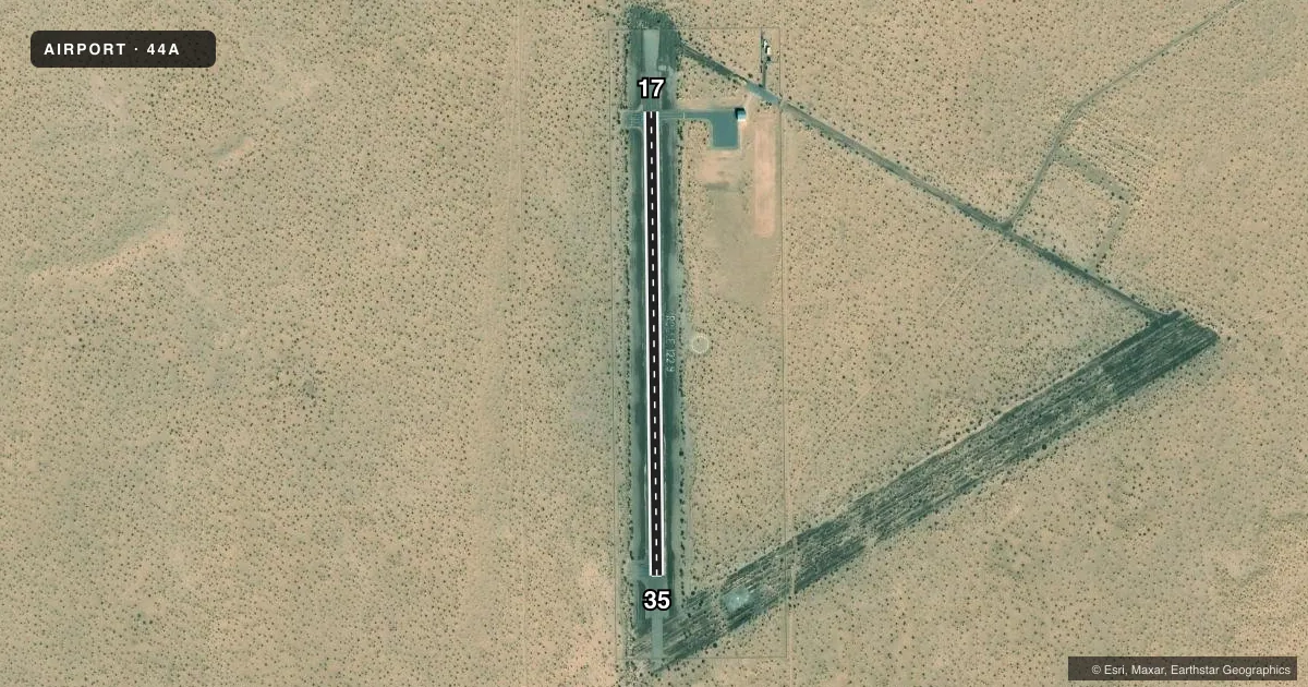
Runways & pattern
Full pagePattern entry · RWY 17
LEFT TRAFFICAirport sketch
Runways drawn to scale from FAA survey coordinates, rendered over satellite imagery. Not for navigation.
Approaches & charts
Services on the field
Fuel grades, oxygen, maintenance, ramp storage and lighting — as declared to the FAA by the airport operator.
Fuel & services
- Fuel
- Not available
- Other services
- PAJA
Ramp & ground
- Transient storage
- Tie-down
- Hangar
- Wind indicator
- Yes
- Segmented circle
- Yes
Fuel & FBOs
Cheapest 100LL and Jet A on the field and nearby. Always confirm with the FBO before taxi.
Airport notes
Surface conditions, obstructions, local procedures, lighting outages and other notes published with each FAA cycle.
General notes
- PAJA ON & INVOF ARPT. MIL NIGHT OPS CONDUCTED. ARPT UNLGTD, FENCED, LOCKED & INACCESSIBLE FM GND. ACES CTLD - 928-941-2396.
- MIL OPS PPR - 928-941-2396.
- FOR CD CTC LOS ANGELES ARTCC AT 661-575-2079.
Runway surface & condition
- 17/35TURN AROUNDS NA; USE RWY TO TURN AROUND.
Other notes
- VFR USE ONLY; CAUTION IN MCAS/YUMA ARPT AREA.
- USE CTAF INVOF ARPT.
- MANAGERJUAN TRASVINA YUMA OPS.
- 17/35OIL TREATED AREA SURROUNDING PAVEMENT RUTTED.
VFR map & nearby airports
VFR sectional. Tap any ICAO chip to open that airport.
Key facts · 44A
Answer card- ICAO
- 44A
- Name
- ROLLE AIRFIELD
- Location
- SAN LUIS, ARIZONA
- Elevation
- 163 ft MSL
- Traffic pattern altitude
- 1,163 ft MSL (1,000 AGL)
- Control tower
- Non-towered (use CTAF)
- Total runways
- 1
- Longest runway
- 17/35 · 2,800 ft
- Published ILS approaches
- 0
- Published frequencies
- 1
- Magnetic variation
- 13°
- Current flight rules
- VFR
- Current wind
- 200° at 12 kt
- Favored runway now
- RWY 17
Rolle Airfield is in San Luis, Arizona. Field elevation is 163 ft MSL. The airport has one runway. Runway 17/35 is 2,800 ft long with an asphalt surface. There is no control tower. CTAF is 122.9. No ILS approaches are published here.
Pattern altitude is not published. Use standard pattern planning only if it fits the current conditions and the airport’s published guidance. The field sits in a military-sensitive area near MCAS Yuma. Published remarks say VFR use only. Military operations require prior permission. The airport is unlighted, fenced, locked and inaccessible from the ground. That matters for night planning. It also matters for any arrival that depends on ground access.
The runway environment has a few items to watch. The oil treated area around the pavement is rutted. Turnarounds are not available. Plan to use the runway to turn around. Published remarks also note Paja on and near the airport. For clearance delivery, contact Los Angeles ARTCC at 661-575-2079. No on-field FBOs are listed. Check the current FAA Chart Supplement or call the airport operator directly before you go.