METAR & TAF KBLH
Current METAR
Observed 07:52Z
KBLH 270752Z AUTO 23011KT 10SM CLR 36/16 A2980 RMK AO2 SLP082 T03610161 404390328 PWINO $
- Wind
- 230° @ 11 kt
- Visibility
- 10 SM
- Temp / Dew
- 36°C / 16°C
- Altimeter
- 29.80 inHg
- Clouds
- CLR
- Density alt
- 3,164 ft
- Ceiling
- Unlimited
- Rules
- VFR
Airport info & contacts
Manager on record, flight service, ARTCC, attendance schedule and pattern altitude — published by the FAA and refreshed every 28 days.
Location
- From city
- 6 NM W
- VFR sectional
- PHOENIX
- Pattern altitude
- 800 ft AGL · 1,200 ft MSL
- ARTCC
- ZLA · LOS ANGELES
- NOTAM facility
- BLH (NOTAM-D)
Airport manager
- Name
- ANGELA JAMISON
- Phone
- 951-955-9418
- Address
- 4080 LEMON STREET, 14TH FLOOR, RIVERSIDE CA 92501
Flight service · Hours
- FSS RAL
- RIVERSIDE1-800-WX-BRIEF
- Attendance
- APR-OCT · 0700-1600
- NOV-MAR · 0800-1700
Frequencies
Tap any row to copy the frequency to your clipboard.
Runways & pattern
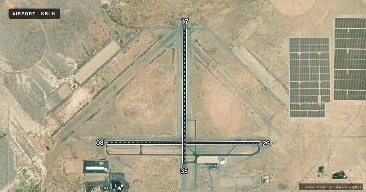
Full pagePattern entry · RWY 26
LEFT TRAFFIC| Runway | Heading (°M) | Length | Surface | Traffic |
|---|---|---|---|---|
| 08/26Favored | 77° / 257° | 6,543 ft | ASPH | Standard L |
| 17/35 | 167° / 347° | 5,800 ft | ASPH | Standard L |
Runway end performance
| End | TORA | TODA | ASDA | LDA | VGSI | Approach lights | Obstruction |
|---|---|---|---|---|---|---|---|
| 26 | — | — | — | — | VASI 4-box left(3°) | — | — |
| 17 | — | — | — | — | VASI 4-box left(3°) | — | — |
| 35 | — | — | — | — | VASI 4-box left(3°) | — | — |
Declared distances in feet. TORA = takeoff run available, TODA = takeoff distance, ASDA = accelerate-stop, LDA = landing distance.
Airport sketch
Runways drawn to scale from FAA survey coordinates, rendered over satellite imagery. Not for navigation.
Approaches & charts
Services on the field
Fuel grades, oxygen, maintenance, ramp storage and lighting — as declared to the FAA by the airport operator.
Fuel & services
- Fuel
- 100LLA
- Oxygen (bottled)
- Not available
- Oxygen (bulk)
- Not available
- Airframe repair
- Not available
- Power plant repair
- Not available
- Other services
- AMB,CARGO,PAJA
Ramp & ground
- Transient storage
- Tie-down
- Hangar
- Landing fee
- No fee published
- Customs
- Not available
- Lighting schedule
- SEE RMK
- Beacon schedule
- SS-SR
- Beacon
- White / Green (civil land)(WG)
- Wind indicator
- Lighted
- Segmented circle
- Yes
Fuel & FBOs
Cheapest 100LL and Jet A on the field and nearby. Always confirm with the FBO before taxi.
Airport notes
Surface conditions, obstructions, local procedures, lighting outages and other notes published with each FAA cycle.
General notes
- ACFT OVER 12500 LBS AVOID HOUSING AREA 1.5 NM SW BLO 2000' FINAL APCH RWY 35 BE ESTABD 2 NM FM TOUCHDOWN.
- DEP FM RY 17 MAKE CLIMBING LEFT TURN SOON AS SAFETY PERMITS. USE WIDE TFC PATTERN FOR RYS 26 & 35.
- POWER PLANT 1 MILE EAST OF ARPT PRODUCING THERMAL PLUMES; AVOID LOW ALTITUDE DIRECT OVERFLIGHT OF THE POWER PLANT.
- PAJA. PRCHT TRNG HIGH AND LOW LVLS ALL HRS NE QUAD OF ARPT
- FOR CD IF UNA TO CTC ON FSS FREQ, CTC LOS ANGELES ARTCC AT 661-575-2079.
Lighting notes
- ACTVT VASI RWY 17, 35 & 26; MIRL RWY 17/35 & 08/26 - CTAF
Other notes
- THIS AIRPORT HAS BEEN SURVEYED BY THE NATIONAL GEODETIC SURVEY.
VFR map & nearby airports
VFR sectional. Tap any ICAO chip to open that airport.
Key facts · KBLH
Answer card- ICAO
- KBLH
- Name
- BLYTHE
- Location
- BLYTHE, CALIFORNIA
- Elevation
- 399.6 ft MSL
- Traffic pattern altitude
- 1,199.6 ft MSL (800 AGL)
- Control tower
- Non-towered (use CTAF)
- Total runways
- 2
- Longest runway
- 08/26 · 6,543 ft
- Published ILS approaches
- 0
- Published frequencies
- 2
- Magnetic variation
- 13°
- Current flight rules
- VFR
- Current wind
- 230° at 11 kt
- Favored runway now
- RWY 26
Blythe Airport (KBLH) sits in Blythe, California. Field elevation is 399.6 ft MSL. The airport has two asphalt runways. The longest is runway 08/26 at 6,543 ft. Runway 17/35 is 5,800 ft. There is no control tower. CTAF and UNICOM are both 122.8.
Pattern altitude is 800 ft AGL, which is 1,199.6 ft MSL. No ILS approaches are published here, so plan on non-precision work and current weather minimums. Patton Aviation is on the field. It carries 100LL, Jet A and Jet A Prist. Call (760) 922-6125 for current services.
A few remarks matter for planning. Visual approach slope indicator lights are available for runways 17, 35 and 26. Medium intensity runway lights are on both runways and are controlled by CTAF. The airport also has published traffic notes. Aircraft over 12,500 pounds should avoid the housing area southwest of the field below 2,000 ft. Parachute training happens in the northeast quadrant at all hours. A power plant one mile east can create thermal plumes. Avoid low altitude direct overflight. If you are departing runway 17, plan a climbing left turn as soon as safety permits. Use a wide pattern for runways 26 and 35.