METAR & TAF 49X
49X does not publish a METAR.
Showing the nearest reporting station: KHII (LAKE HAVASU CITY) · 4.4 NM away. Conditions at 49X may differ.
METAR · KHII
Observed 21:55Z
KHII 262155Z AUTO 21014KT 10SM CLR 45/13 A2979 RMK AO2
- Wind
- 210° @ 14 kt
- Visibility
- 10 SM
- Temp / Dew
- 45°C / 13°C
- Altimeter
- 29.79 inHg
- Clouds
- CLR
- Density alt
- 4,553 ft
- Ceiling
- Unlimited
- Rules
- VFR
Airport info & contacts
Manager on record, flight service, ARTCC, attendance schedule and pattern altitude — published by the FAA and refreshed every 28 days.
Location
- From city
- 4 NM N
- VFR sectional
- PHOENIX
- ARTCC
- ZLA · LOS ANGELES
- NOTAM facility
- RAL (NOTAM-D)
Airport manager
- Name
- STEVEN ESCOBAR
- Phone
- 760-858-1116
- Address
- PO BOX 1976, HAVASU LAKE CA 92363
Flight service · Hours
- FSS RAL
- RIVERSIDE1-800-WX-BRIEF
- Attendance
- Unattended
Frequencies
Tap any row to copy the frequency to your clipboard.
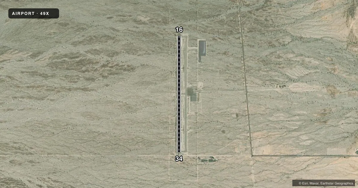
Runways & pattern
Full pagePattern entry · RWY 16
LEFT TRAFFICAirport sketch
Runways drawn to scale from FAA survey coordinates, rendered over satellite imagery. Not for navigation.
Approaches & charts
Services on the field
Fuel grades, oxygen, maintenance, ramp storage and lighting — as declared to the FAA by the airport operator.
Fuel & services
- Fuel
- Not available
Ramp & ground
- Transient storage
- Tie-down
- Lighting schedule
- SEE RMK
- Beacon schedule
- SS-SR
- Beacon
- White / Green (civil land)(WG)
- Wind indicator
- Lighted
- Segmented circle
- Yes
Fuel & FBOs
Cheapest 100LL and Jet A on the field and nearby. Always confirm with the FBO before taxi.
Airport notes
Surface conditions, obstructions, local procedures, lighting outages and other notes published with each FAA cycle.
General notes
- FOR CD CTC LOS ANGELES ARTCC AT 661-575-2079.
Lighting notes
- ACTVT MIRL RWY 16/34 - CTAF.
Other notes
- VFR USE ONLY.
VFR map & nearby airports
VFR sectional. Tap any ICAO chip to open that airport.
Key facts · 49X
Answer card- ICAO
- 49X
- Name
- CHEMEHUEVI VALLEY
- Location
- CHEMEHUEVI VALLEY, CALIFORNIA
- Elevation
- 638.3 ft MSL
- Traffic pattern altitude
- 1,638.3 ft MSL (1,000 AGL)
- Control tower
- Non-towered (use CTAF)
- Total runways
- 1
- Longest runway
- 16/34 · 5,000 ft
- Published ILS approaches
- 0
- Published frequencies
- 1
- Magnetic variation
- 13°
- Current flight rules
- VFR
- Current wind
- 210° at 14 kt
- Favored runway now
- RWY 16
Chemehuevi Valley Airport sits in Chemehuevi Valley, California. Field elevation is 638.3 ft MSL. The airport has one runway. Runway 16/34 is 5,000 ft long and asphalt. There is no control tower. CTAF is 122.9.
No ILS approaches are published here. This is a VFR-only airport, so plan accordingly. Pattern altitude is not published. Use standard 1,000 ft AGL unless current local guidance says otherwise. For this field that works out to about 1,638.3 ft MSL.
The runway lights on 16/34 are medium intensity lights that are activated by the CTAF. For clearance delivery, contact Los Angeles ARTCC at 661-575-2079. There are no on-field FBOs listed, so verify services with the airport operator before you go. First-time pilots should pay attention to the desert setting and the lack of published instrument approaches. Check the current Chart Supplement for any updated operating notes before departure.