METAR & TAF KHII
Current METAR
Observed 04:15Z
KHII 270415Z AUTO 17006KT 10SM CLR 41/14 A2978 RMK AO2
- Wind
- 170° @ 6 kt
- Visibility
- 10 SM
- Temp / Dew
- 41°C / 14°C
- Altimeter
- 29.78 inHg
- Clouds
- CLR
- Density alt
- 4,264 ft
- Ceiling
- Unlimited
- Rules
- VFR
Airport info & contacts
Manager on record, flight service, ARTCC, attendance schedule and pattern altitude — published by the FAA and refreshed every 28 days.
Location
- From city
- 6 NM N
- VFR sectional
- PHOENIX
- ARTCC
- ZLA · LOS ANGELES
- NOTAM facility
- PRC (NOTAM-D)
Airport manager
- Name
- KIP TURNER
- Phone
- 928-764-3330
- Address
- 5600 NORTH HIGHWAY 95 #1, LAKE HAVASU CITY AZ 86404
Flight service · Hours
- FSS PRC
- PRESCOTT1-800-WX-BRIEF
- Attendance
- 0800-1700
Frequencies
Tap any row to copy the frequency to your clipboard.
Runways & pattern
Full pagePattern entry · RWY 14
RIGHT TRAFFICRunway end performance
| End | TORA | TODA | ASDA | LDA | VGSI | Approach lights | Obstruction |
|---|---|---|---|---|---|---|---|
| 14 | — | — | — | — | PAPI 4-box left(3.5°) | — | — |
| 32 | — | — | — | — | PAPI 4-box left(3°) | — | — |
Declared distances in feet. TORA = takeoff run available, TODA = takeoff distance, ASDA = accelerate-stop, LDA = landing distance.
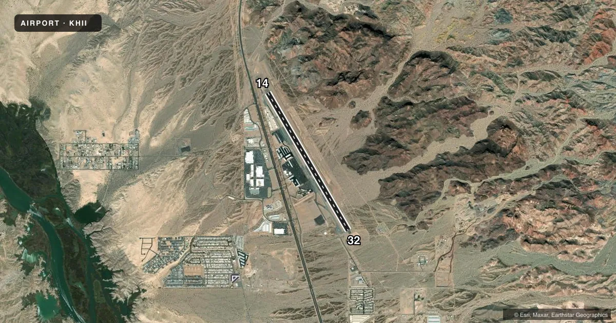
Airport sketch
Runways drawn to scale from FAA survey coordinates, rendered over satellite imagery. Not for navigation.
Approaches & charts
Services on the field
Fuel grades, oxygen, maintenance, ramp storage and lighting — as declared to the FAA by the airport operator.
Fuel & services
- Fuel
- 100LLA
- Oxygen (bottled)
- Low pressure
- Oxygen (bulk)
- Low pressure
- Airframe repair
- Major
- Power plant repair
- Major
- Other services
- AFRT,AMB,AVNCS,CHTR,INSTR,RNTL
Ramp & ground
- Transient storage
- Not published
- Landing fee
- No fee published
- Lighting schedule
- SEE RMK
- Beacon schedule
- SS-SR
- Beacon
- White / Green (civil land)(WG)
- Wind indicator
- Lighted
- Segmented circle
- Yes
Fuel & FBOs
Cheapest 100LL and Jet A on the field and nearby. Always confirm with the FBO before taxi.
Airport notes
Surface conditions, obstructions, local procedures, lighting outages and other notes published with each FAA cycle.
General notes
- NOISE ABATEMENT; ENTER PAT 45 DEG TO DOWNWIND; AVOID OTFC RESIDENTIAL AREAS; PWR LINES, TWRS & HIGH TRRN N/NE.
- ULTRALIGHT OPS S & SW; SFC-5000 FT.
- 1489 FT MSL UNLGT MT TOP 1.4 MI ENE; 1503 FT MSL UNLGT MT TOP 1.7 MI ESE.
- FOR CD CTC LOS ANGELES ARTCC AT 661-575-2079.
Lighting notes
- ACTVT REIL RWY 14/32; MIRLS RWY 14/32 - CTAF.
Runway surface & condition
- 14/32RWY 32 CALM WIND RWY.
Approach & departure obstructions
- 14PAPI BAFFLED & UNUSBL BYD 5 DEG LEFT OF CNTRLN.
Other notes
- TPA 1020 AGL LGT ACFT; 1520 AGL HIGH PERFORMANCE ACFT.
- UNMNT 1700-0500 & WKEND.
VFR map & nearby airports
VFR sectional. Tap any ICAO chip to open that airport.
Key facts · KHII
Answer card- ICAO
- KHII
- Name
- LAKE HAVASU CITY
- Location
- LAKE HAVASU CITY, ARIZONA
- Elevation
- 782.8 ft MSL
- Traffic pattern altitude
- 1,782.8 ft MSL (1,000 AGL)
- Control tower
- Non-towered (use CTAF)
- Total runways
- 1
- Longest runway
- 14/32 · 8,000 ft
- Published ILS approaches
- 0
- Published frequencies
- 2
- Magnetic variation
- 13°
- Current flight rules
- VFR
- Current wind
- 170° at 6 kt
- Favored runway now
- RWY 14
Lake Havasu City Airport (KHII) sits in Lake Havasu City, Arizona. Field elevation is 782.8 ft MSL. The airport has one runway. Runway 14/32 is 8,000 ft long with an asphalt surface. There is no control tower. CTAF and UNICOM are both 122.7. No ILS approaches are published here.
For light aircraft, the published pattern altitude is 1,020 ft AGL. High performance aircraft use 1,520 ft AGL. Runway 32 is the calm wind runway. Noise abatement matters here. Enter the pattern 45 degrees to downwind. Avoid overflying residential areas. The field also has terrain and obstacles north and northeast. There are power lines, towers and high terrain in that area.
Velocity Aviation is on the field. It carries 100LL, Jet A and Jet A Prist. The UNICOM frequency is unmanned from 1700 to 0500 and on weekends, so plan ahead if you need local help on arrival. There is also an unlighted mountain top east of the airport. Use extra care on night arrivals and departures. The PAPI on runway 14 is baffled and is unusable beyond 5 degrees left of centerline. For clearances, contact Los Angeles ARTCC at 661-575-2079.