METAR & TAF KTNP
KTNP does not publish a METAR.
Showing the nearest reporting station: KTRM (JACQUELINE COCHRAN RGNL) · 32.1 NM away. Conditions at KTNP may differ.
METAR · KTRM
Observed 22:52Z
KTRM 222252Z AUTO 14007KT 10SM CLR 43/12 A2971 RMK AO2 SLP062 T04330122
- Wind
- 140° @ 7 kt
- Visibility
- 10 SM
- Temp / Dew
- 43°C / 12°C
- Altimeter
- 29.71 inHg
- Clouds
- CLR
- Density alt
- 5,962 ft
- Ceiling
- Unlimited
- Rules
- VFR
Airport info & contacts
Manager on record, flight service, ARTCC, attendance schedule and pattern altitude — published by the FAA and refreshed every 28 days.
Location
- From city
- 6 NM E
- VFR sectional
- LOS ANGELES
- ARTCC
- ZLA · LOS ANGELES
- NOTAM facility
- RAL (NOTAM-D)
Airport manager
- Name
- TERESA COOK
- Phone
- 760-995-8762
- Address
- 21600 CORWIN ROAD, APPLE VALLEY CA 92307
Flight service · Hours
- FSS RAL
- RIVERSIDE1-800-WX-BRIEF
- Attendance
- Unattended
Frequencies
Tap any row to copy the frequency to your clipboard.
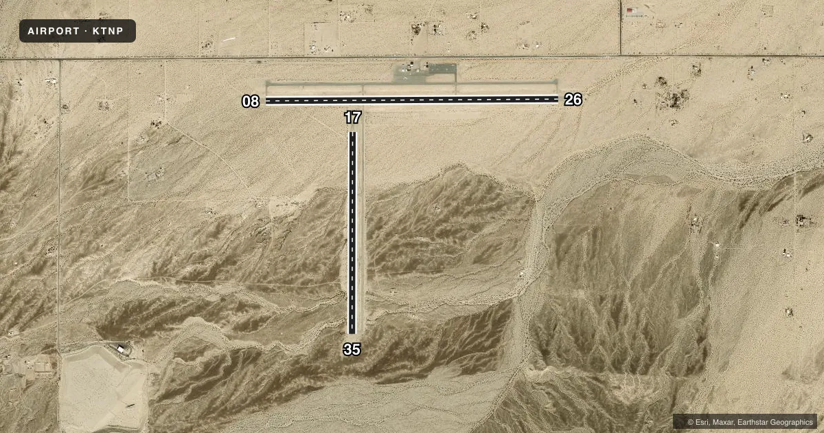
Runways & pattern
Full pagePattern entry · RWY 17
LEFT TRAFFIC| Runway | Heading (°M) | Length | Surface | Traffic |
|---|---|---|---|---|
| 08/26 | 78° / 258° | 5,531 ft | ASPH | Standard L |
| 17/35Favored | 168° / 348° | 3,797 ft | ASPH | Standard L |
Runway end performance
| End | TORA | TODA | ASDA | LDA | VGSI | Approach lights | Obstruction |
|---|---|---|---|---|---|---|---|
| 08 | — | — | — | — | PAPI 2-box left(3°) | — | 120', pline, 4100' from thr, 0' R of cntrln, slope 32 |
| 26 | — | — | — | — | PAPI 2-box left(3°) | — | — |
| 17 | — | — | — | — | — | — | 30', pline, 1400' from thr, 0' R of cntrln, slope 40 |
| 35 | — | — | — | — | — | — | 200', hill, 3300' from thr, 0' R of cntrln, slope 15 |
Declared distances in feet. TORA = takeoff run available, TODA = takeoff distance, ASDA = accelerate-stop, LDA = landing distance.
Airport sketch
Runways drawn to scale from FAA survey coordinates, rendered over satellite imagery. Not for navigation.
Approaches & charts
Services on the field
Fuel grades, oxygen, maintenance, ramp storage and lighting — as declared to the FAA by the airport operator.
Fuel & services
- Fuel
- 100LL
- Oxygen (bottled)
- Not available
- Oxygen (bulk)
- Not available
- Airframe repair
- Minor
- Power plant repair
- Minor
- Other services
- CHTR,INSTR,RNTL,TOW
Ramp & ground
- Transient storage
- Tie-down
- Landing fee
- No fee published
- Customs
- Not available
- Lighting schedule
- SEE RMK
- Beacon schedule
- SS-SR
- Beacon
- White / Green (civil land)(WG)
- Wind indicator
- Lighted
- Segmented circle
- Yes
Fuel & FBOs
Cheapest 100LL and Jet A on the field and nearby. Always confirm with the FBO before taxi.
Airport notes
Surface conditions, obstructions, local procedures, lighting outages and other notes published with each FAA cycle.
General notes
- TWY LGTS ON TWY CONNECTING RWY 08/26 & RWY 17/35; PLUS BLUE REFLECTORS ON PARALLEL TWY SERVING RWY 17/35.
- BE ALERT FOR AEROBATIC ACTIVITY SOUTH OF RY 17/35.
- FOR CD IF UNA TO CTC ON FSS FREQ, CTC LOS ANGELES ARTCC AT 661-575-2079.
Lighting notes
- ACTVT MIRL RY 08/26 AND 17/35; REIL RY 08 AND RY 26 - CTAF.
Fuel notes
- 100LL100LL AVBL 24 HRS.
Approach & departure obstructions
- 35+2 FT TERRAIN AT 200 FT FROM THLD.
- 17PLINES
Other notes
- THIS AIRPORT HAS BEEN SURVEYED BY THE NATIONAL GEODETIC SURVEY.
- AUTOMATED UNICOM.
VFR map & nearby airports
VFR sectional. Tap any ICAO chip to open that airport.
Key facts · KTNP
Answer card- ICAO
- KTNP
- Name
- TWENTYNINE PALMS
- Location
- TWENTYNINE PALMS, CALIFORNIA
- Elevation
- 1,888 ft MSL
- Traffic pattern altitude
- 2,888 ft MSL (1,000 AGL)
- Control tower
- Non-towered (use CTAF)
- Total runways
- 2
- Longest runway
- 08/26 · 5,531 ft
- Published ILS approaches
- 0
- Published frequencies
- 2
- Magnetic variation
- 12°
- Current flight rules
- VFR
- Current wind
- 140° at 7 kt
- Favored runway now
- RWY 17
Twentynine Palms Airport (KTNP) sits in Twentynine Palms, California. Field elevation is 1,888 ft MSL. The airport has two asphalt runways. The longest is 08/26 at 5,531 ft. There is no control tower, so plan for self-announce traffic on CTAF 122.8. Pattern altitude is not published. Use the standard 1,000 ft AGL for light piston operations unless local procedures say otherwise.
No ILS approaches are published here. That matters if you are planning a weather arrival. Check the current charted procedures before you go. The field has one on-field FBO, Twentynine Palms Airport. It carries 100LL. 100LL fuel is available 24 hours. Automated UNICOM is available. That helps when the field is quiet.
A few operational items stand out. Power lines are present near runway 17. There is also a 2-foot terrain obstruction 200 feet from the threshold of runway 35. Runway lights are medium intensity on both runways. REILs are on runways 08 and 26. They are controlled by CTAF. Be alert for aerobatic activity south of runway 17/35. For a first visit, the main things are the desert setting, the elevation and the lack of published ILS support. Expect to brief your arrival and departure carefully.