METAR & TAF KCPM
KCPM does not publish a METAR.
Showing the nearest reporting station: KHHR (JACK NORTHROP FLD/HAWTHORNE MUNI) · 5.0 NM away. Conditions at KCPM may differ.
METAR · KHHR
Observed 10:53Z
KHHR 271053Z AUTO 00000KT 10SM CLR 22/19 A2991 RMK AO2 SLP127 T02170189
- Wind
- 000° @ 0 kt
- Visibility
- 10 SM
- Temp / Dew
- 22°C / 19°C
- Altimeter
- 29.91 inHg
- Clouds
- CLR
- Density alt
- 975 ft
- Ceiling
- Unlimited
- Rules
- VFR
Airport info & contacts
Manager on record, flight service, ARTCC, attendance schedule and pattern altitude — published by the FAA and refreshed every 28 days.
Location
- From city
- 2 NM SW
- VFR sectional
- LOS ANGELES
- Pattern altitude
- 900 ft AGL · 999 ft MSL
- ARTCC
- ZLA · LOS ANGELES
- NOTAM facility
- HHR (NOTAM-D)
Airport manager
- Name
- LATANYA COLLIER
- Phone
- 310-631-6140
- Address
- 901 W ALONDRA BLVD, COMPTON CA 90220-3528
Flight service · Hours
- FSS HHR
- HAWTHORNE1-800-WX-BRIEF
- Attendance
- ALL
Frequencies
Tap any row to copy the frequency to your clipboard.
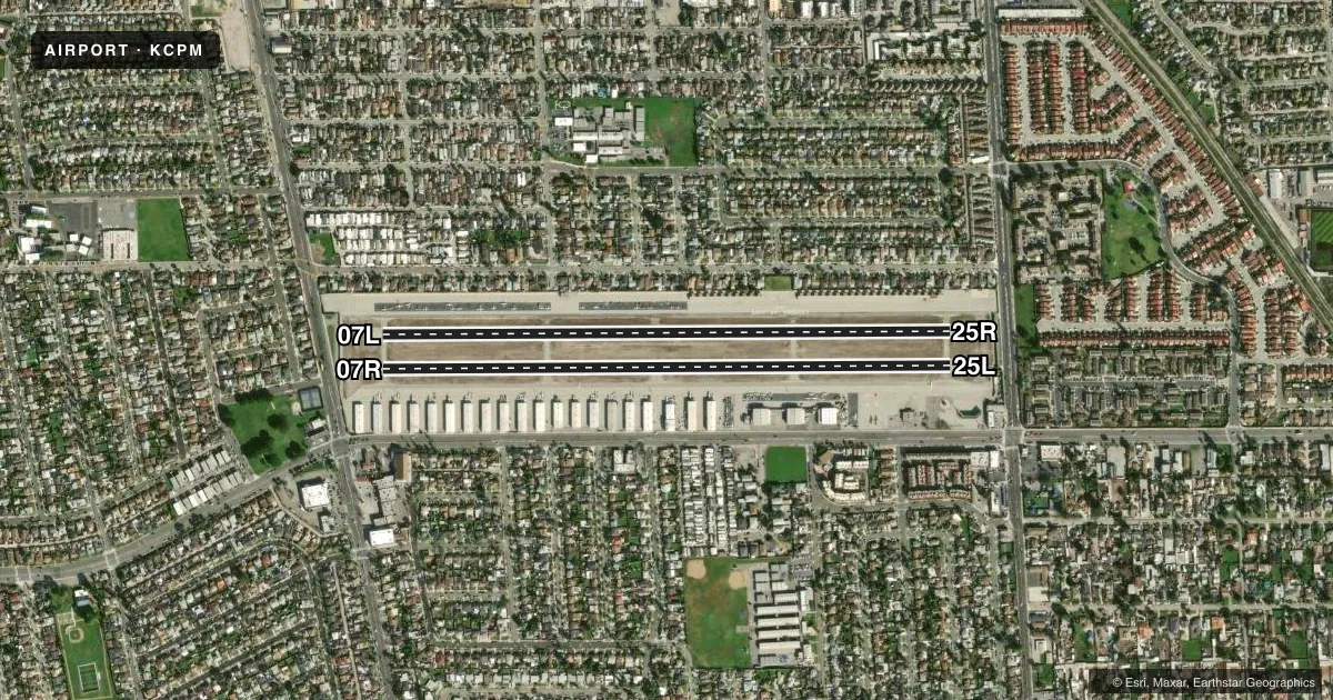
Runways & pattern
Full pagePattern entry · RWY 07L
RIGHT TRAFFIC| Runway | Heading (°M) | Length | Surface | Traffic |
|---|---|---|---|---|
| 07L/25R | 75° / 255° | 3,323 ft | ASPH | 07L R |
| 07R/25L | 75° / 255° | 3,322 ft | ASPH | 07R R |
Runway end performance
| End | TORA | TODA | ASDA | LDA | VGSI | Approach lights | Obstruction |
|---|---|---|---|---|---|---|---|
| 07L | — | — | — | — | — | — | 19', road, 200' from thr, 0' R of cntrln, slope 0 |
| 25R | — | — | — | — | — | — | 15', road, 200' from thr, 0' R of cntrln, slope 0 |
| 07R | — | — | — | — | — | — | 19', road, 200' from thr, 0' R of cntrln, slope 0 |
| 25L | — | — | — | — | PAPI 2-box right(4°) | — | 15', road, 200' from thr, 0' R of cntrln, slope 0 |
Declared distances in feet. TORA = takeoff run available, TODA = takeoff distance, ASDA = accelerate-stop, LDA = landing distance.
Airport sketch
Runways drawn to scale from FAA survey coordinates, rendered over satellite imagery. Not for navigation.
Approaches & charts
Services on the field
Fuel grades, oxygen, maintenance, ramp storage and lighting — as declared to the FAA by the airport operator.
Fuel & services
- Fuel
- 100LL
- Oxygen (bottled)
- Not available
- Oxygen (bulk)
- Not available
- Airframe repair
- Major
- Power plant repair
- Major
- Other services
- INSTR,RNTL,SALES
Ramp & ground
- Transient storage
- Tie-down
- Landing fee
- No fee published
- Customs
- Not available
- Lighting schedule
- SEE RMK
- Beacon schedule
- SS-SR
- Beacon
- White / Green (civil land)(WG)
- Wind indicator
- Lighted
- Segmented circle
- Yes
Fuel & FBOs
Cheapest 100LL and Jet A on the field and nearby. Always confirm with the FBO before taxi.
Airport notes
Surface conditions, obstructions, local procedures, lighting outages and other notes published with each FAA cycle.
General notes
- PLANES PARKED 145 FT NORTH OF CENTERLINE 07L/25R AND 158 FT SOUTH OF CENTERLINE 07R/25L.
- REQ ALL TRAFFIC REMAIN SOUTH OF AIRPORT. AVOID OVERFLIGHT OF SCHOOLS 2900 FT EAST.
- ONLY SOUTH SIDE OF NORTH PARALLEL TAXIWAY LIGHTED; ONLY NORTH SIDE OF SOUTH PARALLEL TAXIWAY LIGHTED.
- RY 25L/25R CALM WIND RUNWAY.
- NO TOUCH AND GO LANDINGS
- SKID EQUIPPED HELICOPTERS ARE NOT PERMITTED TO TOUCH DOWN ON RUNWAYS. HELICOPTER OPERATIONS RESTRICTED TO THE RUNWAYS AND SOUTH APRONS.
- FOR CD CTC SOCAL APCH AT 800-448-3724.
- ACFT PARKED IN TIE-DOWNS ALONG TWY A AND TWY B ARE WI THE TWY OBJECT FREE AREA (TOFA).
Lighting notes
- ACTVT REIL & PAPI RWY 25L; MIRL RWY 07R/25L; N AND S PARL TWYS - CTAF.
Runway surface & condition
- 07L/25RCLSD NIGHTS INDEFLY; ONLY VFR OPNS DURG DAY.
Approach & departure obstructions
- 07L6 FT FENCE 70 FT FM THLD PERPENDICULAR TO CNTRLN +8 FT WALL 90 FT FM THLD PERPENDICULAR TO CNTRLN; +30 FT PLINE 200 FT FM RY END 125 FT R TO 125 FT L.
- 07R6 FT FENCE 70 FT FM THLD PERPENDICULAR TO CNTRLN +8 FT WALL 90 FT FM THLD PERPENDICULAR TO CNTRLN; +30 FT PLINE 125 FT FM RY END 125 FT R TO 125 FT L.
- 25L+6 FT FENCE 45 FT TO 70 FT FROM THRESHOLD, +8 FT WALL 70 FT TO 90 FT FROM THRESHOLD, +15 FT STREET 125 FT R 120 FT TO 200 FT FROM THRESHOLD THROUGH 125 FT L 120 FT TO 200 FT FROM THR.
- 25R+6 FT FENCE 60 FT TO 70 FT FROM THRESHOLD, +8 FT WALL 75 FT TO 85 FT FROM THRESHOLD, +15 FT STREET 125 FT R 105 FT TO 200 FT FROM THRESHOLD THROUGH 125 FT L 120 FT TO 200 FT FROM THR.
- 07LAPCH RATIO TO DSPLCD THLD OVER +40 FT TREE 1195 FT FM DSPLCD THLD 29:1.
- 07RAPCH RATIO TO DSPLCD THLD OVER +35 FT POLE 1145 FT FM DSPLCD THLD 130 FT RIGHT 32:1.
- 25LAPCH RATIO 50:1 TO DSPLCD THLD.
- 25RAPCH RATIO 50:1 TO DSPLCD THLD.
Other notes
- OWNERLA COUNTY CTC: PAUL MASELBAS, 626-300-4600 X4615.
VFR map & nearby airports
VFR sectional. Tap any ICAO chip to open that airport.
Key facts · KCPM
Answer card- ICAO
- KCPM
- Name
- COMPTON/WOODLEY
- Location
- COMPTON, CALIFORNIA
- Elevation
- 98.7 ft MSL
- Traffic pattern altitude
- 998.7 ft MSL (900 AGL)
- Control tower
- Non-towered (use CTAF)
- Total runways
- 2
- Longest runway
- 07L/25R · 3,323 ft
- Published ILS approaches
- 0
- Published frequencies
- 2
- Magnetic variation
- 14°
- Current flight rules
- VFR
- Current wind
- 000° at 0 kt
- Favored runway now
- –
Compton/Woodley Airport sits in Compton, California at 98.7 ft MSL. It has two asphalt runways. The longest is 3,323 ft. There is no control tower, so pilots use CTAF and UNICOM 123.05 for local traffic calls. No ILS approaches are published here. Pattern altitude is 900 ft AGL, which is 998.7 ft MSL.
The on-field FBO is Compton/Woodley Airport. It carries AVGAS 100LL. Call the field directly at (310) 631-8140 for current service details. Published remarks matter here. Runway 07L/25R is closed at night indefinitely. Only daytime VFR operations are permitted on that runway. All traffic is required to remain south of the airport. Avoid overflight of schools 2,900 ft east. There are also several threshold and approach obstructions called out in the Chart Supplement, so review the current notes before arrival.
This is a busy local-use field with tight surface movement areas. Helicopter operations are limited to the runways and south aprons. Skid-equipped helicopters may not touch down on the runways. For clearance delivery, contact SoCal Approach at 800-448-3724. If you are new to KCPM, plan on a careful pattern. Watch the south-of-field traffic flow. Verify the current Chart Supplement for any updated runway or operational notes before you go.