METAR & TAF KPMD
Current METAR
Observed 01:53Z
KPMD 270153Z 27016KT 10SM CLR 34/08 A2997 RMK AO2 SLP117 T03390083 $
- Wind
- 270° @ 16 kt
- Visibility
- 10 SM
- Temp / Dew
- 34°C / 8°C
- Altimeter
- 29.97 inHg
- Clouds
- CLR
- Density alt
- 5,371 ft
- Ceiling
- Unlimited
- Rules
- VFR
Airport info & contacts
Manager on record, flight service, ARTCC, attendance schedule and pattern altitude — published by the FAA and refreshed every 28 days.
Location
- From city
- 3 NM NE
- VFR sectional
- LOS ANGELES
- ARTCC
- ZLA · LOS ANGELES
- NOTAM facility
- PMD (NOTAM-D)
Airport manager
- Name
- MATT FISHER
- Phone
- 661-275-9342
- Address
- 2503 E AVE P, PALMDALE CA 93550-2196
Flight service · Hours
- FSS RAL
- RIVERSIDE1-800-WX-BRIEF
- Attendance
- 1330-0600Z++
Frequencies
Tap any row to copy the frequency to your clipboard.
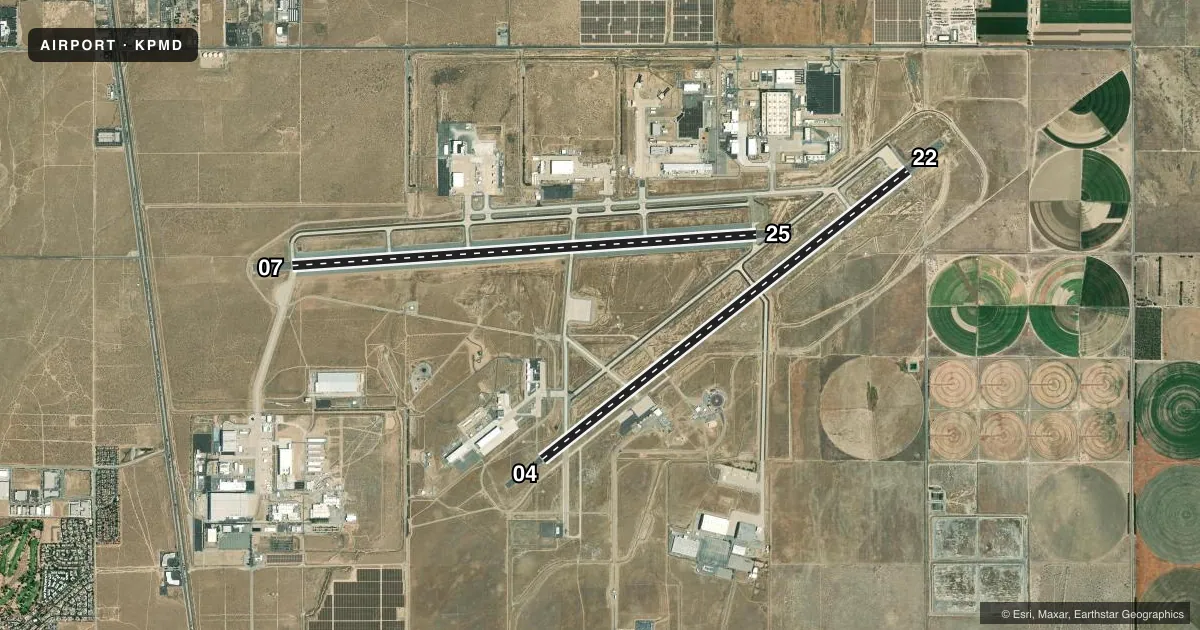
Runways & pattern
Full pagePattern entry · RWY 25
RIGHT TRAFFIC| Runway | Heading (°M) | Length | Surface | Traffic |
|---|---|---|---|---|
| 07/25Favored | 74° / 254° | 12,002 ft | CONC | 25 R |
| 04/22 | 40° / 220° | 12,001 ft | CONC | 04 R |
Runway end performance
| End | TORA | TODA | ASDA | LDA | VGSI | Approach lights | Obstruction |
|---|---|---|---|---|---|---|---|
| 07 | — | — | — | — | PAPI 4-box left(3°) | — | — |
| 25 | — | — | — | — | PAPI 4-box left(3°) | — | — |
| 04 | — | — | — | — | PAPI 4-box left(3°) | — | hill, slope 35 |
| 22 | — | — | — | — | PAPI 4-box left(3°) | — | — |
Declared distances in feet. TORA = takeoff run available, TODA = takeoff distance, ASDA = accelerate-stop, LDA = landing distance.
Airport sketch
Runways drawn to scale from FAA survey coordinates, rendered over satellite imagery. Not for navigation.
Approaches & charts
ILS · 1
Services on the field
Fuel grades, oxygen, maintenance, ramp storage and lighting — as declared to the FAA by the airport operator.
Fuel & services
- Fuel
- Not available
Ramp & ground
- Transient storage
- Not published
- Landing fee
- Yes
- Customs
- Not available
- Lighting schedule
- SEE RMK
- Beacon schedule
- SS-SR
- Beacon
- White / Green (civil land)(WG)
- Wind indicator
- Yes
- Segmented circle
- Yes
Fuel & FBOs
Cheapest 100LL and Jet A on the field and nearby. Always confirm with the FBO before taxi.
Airport notes
Surface conditions, obstructions, local procedures, lighting outages and other notes published with each FAA cycle.
General notes
- MISC: INDUS INSTLN - NO TRNSPN, LODGING OR NML SVC AVBL ON SITE.
- PRKG RAMP LCTD S OF RWY 22 & TWY V NOT VSB FM ATCT.
- UNLGT OBSTN SURROUND AFLD.
- DRAINAGE DITCHES PARL RWY 22 FM TWY S TO TWY U.
- BIRD HAZ POTENTIAL EXISTS. MIGRATORY SEASON PHASE II 1 OCT - 31 MAR. DURG BWC MODERATE, TKOF AND LNDG PERMITTED. DURG BWC SEVERE, TKOF AND LNDG PROHIBITED.
- MILITARY USE: ASSAULT LDG ZONE LCTD 1ST 6,000 EAST END OF TWY B. RWY 252 MRK ONLY FOR C-130 ASSAULT OPR; ONE-WAY LDG ONLY.
- MISC: WINDS ARE EST DUE TO FMQ-13 WIND SENSORS BEING ACCURATE TO WITHIN ONLY +/- 2 KT. ATC/WX WILL NOT INCL/RELAY WIND CORR INTO FCST/PHRASEOLOGY. THEREFORE, AIRCREWS WILL INCORPORATE A +/- 2 KT ACCURACY INTO THEIR DECISION MAKING PROCESS FOR FLYING OPR.
- TRAN ALERT (1 OF 2): NO FLEET SVC AVBL. NO FLW ME SVC AVBL. EXP PROGRESSIVE TAXI TO PRK. AIRCREW RESPONSIBLE FOR ACFT PINNING/SAFING.
- MISC: COMSEC STORAGE UNAVBL.
- CAUTION: USE EXTREME CAUTION FOR UNMANNED AERIAL SYSTEMS (UAS) OPS IN VCNTY.
- FUEL: A++ AVBL. NO TRANS ACFT FUEL SVC AVBL. LTD FUELING AVBL; GOVT ACFT ONLY 1600-2300Z++ MON-FRI. 24 HR PN WITH AFLD MGR RQR; NO SAME DAY REQ; GAS AND GO UNAVBL. EXPECT 2+ HR DELAY FOR FUEL.
- RSTD - OFFL BUS ONLY. MIL ARPT. CIVIL USE RQR USAF APVL AND DD FORM 2400/01/02. PPR RQR FOR FULL STOP LDG ONLY. CALL C661-275-9342.
- TRAN ALERT (2 OF 2): UNABLE TO SVC ACFT WITH ORDNANCE. LTD GRD SUPPORT EQUIPMENT AVBL. NO POTABLE WATER SVC. NO TRAN MAINT AVBL. GND SVC UNAVBL WHEN LIGHTNING WITHIN 5 NM.
- MISC: FLT PLANS MUST BE FILED AND ACTIVATED WITH P42 AFLD MGMT. USE FLT SVC WHEN P42 AFLD MGMT CLSD.
- CAUTION: VARIOUS ACFT TEST OPS MARKINGS PAINTED IN WHITE ON TAXIWAY UNIFORM.
- CAUTION: RWY 25 NSTD MRK: SPOT LDG ZONE MRK LCTD AT 6000 FT REMAINING MRK. RWY 07-25 DECEPTIVE SFC MRK EXCEED STANDARD BY APPROX 50 FT.
- RSTD: OVERNIGHT PRK UNAUTHD ON C-RAMP.
- RSTD: TWY L BTN RWY 04/22 AND PAX TRML UNLGTD AND USABLE FOR DAYLT VFR ONLY.
- ALL DEPT ACFT MUST FILE FPL WITH P42 AFLD MGMT OPS.
- SERVICE-JASU: POWER CARS UNAVBL.
- MISC: BASE OPS OPR 1330-0600Z++, CLSD FEDERAL HOL.
- CAUTION: CONTRACTOR LEASED SITES ARE INTENDED FOR ACFT BASED THEREIN; ENTRY GATES AND APRONS MAY NOT MEET AF OBST STDS.
- CAUTION: CIV ACFT MAY NOT BE GRANTED ACCESS TO KPMD CLASS D FOR PRACTICE APCH OR TRSN OVER ARPT BDRYS.
Lighting notes
- PAPI RWY 04, 07, 22, & 25 OPR CONSLY.
Runway surface & condition
- 072/252RY USED AS A MILITARY ASSAULT STRIP.
- 07/251000 FT ASPH OVRN EACH END; OVRN POOR COND EMERG USE ONLY.
Approach & departure obstructions
- 04UNUSBL BYD 5.0 NM.
- 07UNUSBL BYD 5.0 NM DUE TO TRRN.
- 0423000' FM THR.
Other notes
- THIS AIRPORT HAS BEEN SURVEYED BY THE NATIONAL GEODETIC SURVEY.
- ESTABD PRIOR TO 5/15/59.
- OFFICAL BUSINESS ONLY. MILITARY ARPT. CIVIL USE REQUIRES USAF APPROVAL AND DD FORM 2400/01/02.
- PRIMLY TRMG 747-707-727.
- TPA OHD 1957 FT. RECTANGULAR 1457 FT. EXP RIGHT TFC RWY 04, 25.
- 3CLSD FED HOL.
- 3OTHER TIMES CLSD TO ALL TFC WITHOUT WRITTEN APVL.
- MANAGERCIVILIAN AIRPORT CONTACT AT 39516 NORTH 25TH STREET E, PALMDALE, CA 93550, CURRENTLY CLOSED.
- MANAGERCHIEF OF USAF AIRFIELD OPERATIONS.
- OWNERKEN NEITZEL, FLIGHT DIRECTOR, PHONE 661-275-9341.
VFR map & nearby airports
VFR sectional. Tap any ICAO chip to open that airport.
Key facts · KPMD
Answer card- ICAO
- KPMD
- Name
- PALMDALE USAF PLANT 42
- Location
- PALMDALE, CALIFORNIA
- Elevation
- 2,542.5 ft MSL
- Traffic pattern altitude
- 3,542.5 ft MSL (1,000 AGL)
- Control tower
- Towered · OPR 1330-0600Z++.
- Total runways
- 2
- Longest runway
- 07/25 · 12,002 ft
- Published ILS approaches
- 1
- Published frequencies
- 11
- Magnetic variation
- 12°
- Current flight rules
- VFR
- Current wind
- 270° at 16 kt
- Favored runway now
- RWY 25
Palmdale USAF Plant 42 sits in Palmdale, California in the Antelope Valley. Field elevation is 2,542.5 ft MSL. The airport has two concrete runways. Runway 07/25 is 12,002 ft. Runway 04/22 is 12,001 ft. The tower is open OPR 1330-0600Z++. One ILS is published for runway 25. Pattern altitude is not published, so a light piston pilot should verify the current traffic pattern in the Chart Supplement or with the tower before arrival.
This is a military field with some special operating limits. Departing aircraft must file a flight plan with Plant 42 airfield management. Flight plans also must be activated there. If that office is closed, use flight service. Published remarks also note bird hazard potential, with seasonal migration from October 1 through March 31. During bird watch condition moderate, takeoff and landing are permitted. During severe bird watch condition, they are not.
No on-field FBOs are listed. Fuel service is limited and is for government aircraft only. The field also notes that taxiway L between runways 04/22 and the passenger terminal is unlighted and for daylight VFR only. PAPI is continuous on runways 04, 07, 22 and 25. Winds are estimated with a stated plus or minus 2 knot accuracy. Plan your takeoff and landing with that in mind.