METAR & TAF L71
L71 does not publish a METAR.
Showing the nearest reporting station: KMHV (MOJAVE AIR & SPACE PORT/RUTAN FLD) · 8.6 NM away. Conditions at L71 may differ.
METAR · KMHV
Observed 06:15Z
KMHV 270615Z AUTO 27011G20KT 220V320 10SM CLR 28/04 A3001 RMK AO2 T02780044
- Wind
- 270° @ 11G20 kt
- Visibility
- 10 SM
- Temp / Dew
- 28°C / 4°C
- Altimeter
- 30.01 inHg
- Clouds
- CLR
- Density alt
- 4,491 ft
- Ceiling
- Unlimited
- Rules
- VFR
Airport info & contacts
Manager on record, flight service, ARTCC, attendance schedule and pattern altitude — published by the FAA and refreshed every 28 days.
Location
- From city
- 2 NM NW
- VFR sectional
- LOS ANGELES
- ARTCC
- ZLA · LOS ANGELES
- NOTAM facility
- RAL (NOTAM-D)
Airport manager
- Name
- MARION CATO
- Phone
- 760-338-1013
- Address
- 21000 HACIENDA BOULEVARD, CALIFORNIA CITY CA 93505
Flight service · Hours
- FSS RAL
- RIVERSIDE1-800-WX-BRIEF
- Attendance
- 0800-1700
Frequencies
Tap any row to copy the frequency to your clipboard.
Runways & pattern
Full pagePattern entry · RWY 24
RIGHT TRAFFICRunway end performance
| End | TORA | TODA | ASDA | LDA | VGSI | Approach lights | Obstruction |
|---|---|---|---|---|---|---|---|
| 24 | — | — | — | — | PAPI 2-box left(3°) | — | — |
Declared distances in feet. TORA = takeoff run available, TODA = takeoff distance, ASDA = accelerate-stop, LDA = landing distance.
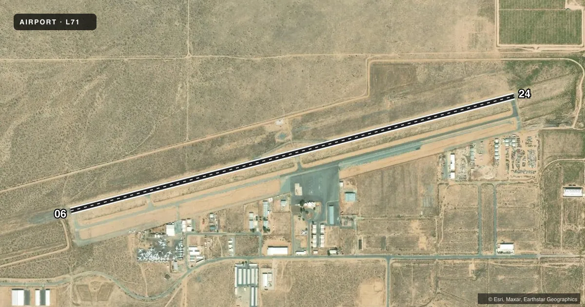
Airport sketch
Runways drawn to scale from FAA survey coordinates, rendered over satellite imagery. Not for navigation.
Approaches & charts
Services on the field
Fuel grades, oxygen, maintenance, ramp storage and lighting — as declared to the FAA by the airport operator.
Fuel & services
- Fuel
- 100LLA
- Oxygen (bottled)
- Low pressure
- Airframe repair
- Minor
- Power plant repair
- Minor
- Other services
- GLD,INSTR,PAJA,RNTL,TOW
Ramp & ground
- Transient storage
- Tie-down
- Landing fee
- No fee published
- Customs
- Not available
- Lighting schedule
- SEE RMK
- Beacon schedule
- SEE RMK
- Beacon
- White / Green (civil land)(WG)
- Wind indicator
- Yes
- Segmented circle
- Yes
Fuel & FBOs
Cheapest 100LL and Jet A on the field and nearby. Always confirm with the FBO before taxi.
Airport notes
Surface conditions, obstructions, local procedures, lighting outages and other notes published with each FAA cycle.
General notes
- RY 06/24 PAEW ADJ RY 0700-1500 DLY.
- FOR CD CTC JOSHUA APCH AT 661-277-3843.
- PAPI AND RWY LGTS ARE OTS. ARPT CLSD TO NGT OPS UFN.
Lighting notes
- ARPT CLSD TO NGT OPS UFN.
- REIL RWY 24; PAPI RWY 24; MIRL RWY 6/24 OTS UFN.
Runway surface & condition
- 06/24OTS UFN.
Approach & departure obstructions
- 24OTS UFN.
Other notes
- THIS AIRPORT HAS BEEN SURVEYED BY THE NATIONAL GEODETIC SURVEY.
- VFR CONDITIONS ONLY.
VFR map & nearby airports
VFR sectional. Tap any ICAO chip to open that airport.
Key facts · L71
Answer card- ICAO
- L71
- Name
- CALIFORNIA CITY MUNI
- Location
- CALIFORNIA CITY, CALIFORNIA
- Elevation
- 2,453.5 ft MSL
- Traffic pattern altitude
- 3,453.5 ft MSL (1,000 AGL)
- Control tower
- Non-towered (use CTAF)
- Total runways
- 1
- Longest runway
- 06/24 · 6,027 ft
- Published ILS approaches
- 0
- Published frequencies
- 4
- Magnetic variation
- 14°
- Current flight rules
- VFR
- Current wind
- 270° at 11 kt
- Favored runway now
- RWY 24
California City Muni sits in California City, California. Field elevation is 2,453.5 ft MSL. The airport has one runway. Runway 06/24 is 6,027 ft of asphalt, which gives light aircraft plenty of room and gives bigger singles a workable strip in good conditions. There is no control tower. CTAF and UNICOM are both 122.7. Joshua Approach uses 133.65 and 348.7. Clearance delivery is handled through Joshua Approach at 661-277-3843.
No ILS approaches are published here. Pattern altitude is not published, so use the standard 1,000 ft AGL for light piston traffic unless the current Chart Supplement says otherwise. Published remarks say this field is VFR only. Night operations are closed until further notice. Runway lighting is also out of service until further notice. The PAPI on runway 24 is out of service. The runway end identifier lights on runway 24 are out of service too. There is also a precision approach path indicator east wing adjacent to runway 06/24 from 0700 to 1500 daily, so plan your visual work with that in mind.
The on-field FBO is California City Municipal Airport. It carries 100LL and Jet A. If you are planning a first stop here, treat it as a daytime VFR field and verify current status before departure. The lighting outages matter here, especially after sunset or if you are arriving close to dusk.