METAR & TAF KIYK
KIYK does not publish a METAR.
Showing the nearest reporting station: KMHV (MOJAVE AIR & SPACE PORT/RUTAN FLD) · 39.3 NM away. Conditions at KIYK may differ.
METAR · KMHV
Observed 20:55Z
KMHV 262055Z AUTO 29009KT 10SM BKN200 BKN220 36/05 A3001 RMK AO2 T03640054 55008
- Wind
- 290° @ 9 kt
- Visibility
- 10 SM
- Temp / Dew
- 36°C / 5°C
- Altimeter
- 30.01 inHg
- Clouds
- BKN
- Density alt
- 5,455 ft
- Ceiling
- 20,000 ft AGL
- Rules
- VFR
Airport info & contacts
Manager on record, flight service, ARTCC, attendance schedule and pattern altitude — published by the FAA and refreshed every 28 days.
Location
- From city
- 1 NM NW
- VFR sectional
- LOS ANGELES
- ARTCC
- ZLA · LOS ANGELES
- NOTAM facility
- IYK (NOTAM-D)
Airport manager
- Name
- SCOTT A. SEYMOUR
- Phone
- 760-377-5844
- Address
- 1669 AIRPORT ROAD, INYOKERN CA 93527
Flight service · Hours
- FSS RAL
- RIVERSIDE1-800-WX-BRIEF
- Attendance
- MON-FRI · 0730-1600
Frequencies
Tap any row to copy the frequency to your clipboard.
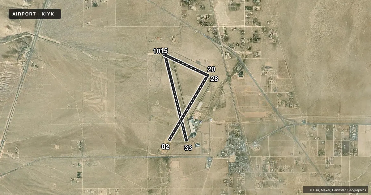
Runways & pattern
Full pagePattern entry · RWY 28
LEFT TRAFFIC| Runway | Heading (°M) | Length | Surface | Traffic |
|---|---|---|---|---|
| 15/33 | 152° / 332° | 7,100 ft | ASPH | Standard L |
| 02/20 | 17° / 197° | 6,275 ft | ASPH | 20 R |
| 10/28Favored | 101° / 281° | 4,150 ft | ASPH | Standard L |
Runway end performance
| End | TORA | TODA | ASDA | LDA | VGSI | Approach lights | Obstruction |
|---|---|---|---|---|---|---|---|
| 15 | — | — | — | — | PAPI 2-box left(3°) | — | — |
| 33 | — | — | — | — | PAPI 2-box left(3.3°) | — | — |
| 02 | — | — | — | — | PAPI 2-box left(3.3°) | — | — |
| 20 | — | — | — | — | VASI 4-box left(3°) | — | — |
Declared distances in feet. TORA = takeoff run available, TODA = takeoff distance, ASDA = accelerate-stop, LDA = landing distance.
Airport sketch
Runways drawn to scale from FAA survey coordinates, rendered over satellite imagery. Not for navigation.
Approaches & charts
Services on the field
Fuel grades, oxygen, maintenance, ramp storage and lighting — as declared to the FAA by the airport operator.
Fuel & services
- Fuel
- 100LLA
- Airframe repair
- Minor
- Power plant repair
- Minor
- Other services
- AFRT,GLD,INSTR,TOW
Ramp & ground
- Transient storage
- Tie-down
- Hangar
- Landing fee
- No fee published
- Lighting schedule
- SEE RMK
- Beacon schedule
- SS-SR
- Beacon
- White / Green (civil land)(WG)
- Wind indicator
- Lighted
- Segmented circle
- Yes
Fuel & FBOs
Cheapest 100LL and Jet A on the field and nearby. Always confirm with the FBO before taxi.
Airport notes
Surface conditions, obstructions, local procedures, lighting outages and other notes published with each FAA cycle.
General notes
- RY 02/20 & 15/33 HAVE DSTC RMNG SIGNS.
- FREQUENT GLIDER OPNS ON WEEKENDS.
- FOR CD CTC LOS ANGELES ARTCC AT 661-575-2079.
Lighting notes
- ACTVT VASI RWY 20; MIRL RWYS 02/20, 10/28, 15/33 - CTAF. PAPI RWYS 02, 15 & 33 OPR CONSLY.
Fuel notes
- 100LLAFTER 1600 CALLOUT FEE FOR SVC CALL (760) 382-3383.
Other notes
- THIS AIRPORT HAS BEEN SURVEYED BY THE NATIONAL GEODETIC SURVEY.
- AUTOMATED UNICOM - 3 CLICKS FOR ARPT ADVISORY & WEATHER OR DIAL 617-262-3825, 4 CLICKS FOR RADIO CHECK.
- MANAGERAIRPORT DIRECTOR. EMAIL: SCOTT@INYOKERNAIRPORT.COM
- 10/28POOR BUT STABLE. PTNS OF RWY CTRLN MARKING OBSCD BY CRACK FILLER.
- 15/33PAVEMENT EXPERIENCING LONGL AND LATERAL BLOCK CRACKING ON PTNS OF RWY.
VFR map & nearby airports
VFR sectional. Tap any ICAO chip to open that airport.
Key facts · KIYK
Answer card- ICAO
- KIYK
- Name
- INYOKERN
- Location
- INYOKERN, CALIFORNIA
- Elevation
- 2,457 ft MSL
- Traffic pattern altitude
- 3,457 ft MSL (1,000 AGL)
- Control tower
- Non-towered (use CTAF)
- Total runways
- 3
- Longest runway
- 15/33 · 7,100 ft
- Published ILS approaches
- 0
- Published frequencies
- 4
- Magnetic variation
- 14°
- Current flight rules
- VFR
- Current wind
- 290° at 9 kt
- Favored runway now
- RWY 28
Inyokern Airport (KIYK) sits in Inyokern, California at 2,457 ft MSL. It has three asphalt runways. The longest is runway 15/33 at 7,100 ft. This is an untowered field, so use CTAF 122.8 for local traffic and UNICOM. Pattern altitude is not published. Use 3,457 ft MSL for light piston operations if you are flying the standard 1,000 ft AGL pattern.
No ILS approaches are published here. The airport uses JOSHUA approach and departure frequencies on 133.65 and 348.7. Runway 02/20 has medium intensity lights. It also has a VASI on 20 and a PAPI on 02. Runways 10/28 and 15/33 also have medium intensity lights. The field has an on-site FBO, Inyokern Airport, which carries 100LL and Jet A. Call ahead if you need fuel after 1600. A callout fee applies for 100LL service after that time.
This is a high-desert airport with a 14° magnetic variation. Expect density altitude to matter on warm days. Frequent glider operations occur on weekends. Runway 15/33 has reported block cracking in places. Runway 10/28 is described as poor but stable. Some centerline marking is obscured by crack filler. Check the current FAA Chart Supplement before you go. Use it for any current operational notes, lighting details, or clearance delivery updates.