METAR & TAF L72
L72 does not publish a METAR.
Showing the nearest reporting station: KMHV (MOJAVE AIR & SPACE PORT/RUTAN FLD) · 60.6 NM away. Conditions at L72 may differ.
METAR · KMHV
Observed 03:35Z
KMHV 270335Z AUTO 28019G23KT 10SM CLR 30/05 A3000 RMK AO2 T02950049
- Wind
- 280° @ 19G23 kt
- Visibility
- 10 SM
- Temp / Dew
- 30°C / 5°C
- Altimeter
- 30.00 inHg
- Clouds
- CLR
- Density alt
- 3,831 ft
- Ceiling
- Unlimited
- Rules
- VFR
Airport info & contacts
Manager on record, flight service, ARTCC, attendance schedule and pattern altitude — published by the FAA and refreshed every 28 days.
Location
- From city
- 4 NM N
- VFR sectional
- LAS VEGAS
- ARTCC
- ZLA · LOS ANGELES
- NOTAM facility
- RAL (NOTAM-D)
Airport manager
- Name
- GEORGE BASS
- Phone
- (928) 592-3427
- Address
- PO BOX 70, TRONA CA 93552
Flight service · Hours
- FSS RAL
- RIVERSIDE1-800-WX-BRIEF
- Attendance
- IREG
Frequencies
Tap any row to copy the frequency to your clipboard.
Runways & pattern
Full pagePattern entry · RWY 35
LEFT TRAFFICRunway end performance
| End | TORA | TODA | ASDA | LDA | VGSI | Approach lights | Obstruction |
|---|---|---|---|---|---|---|---|
| 17 | — | — | — | — | — | — | 7', fence, 346' from thr, 0' R of cntrln, slope 20 |
Declared distances in feet. TORA = takeoff run available, TODA = takeoff distance, ASDA = accelerate-stop, LDA = landing distance.
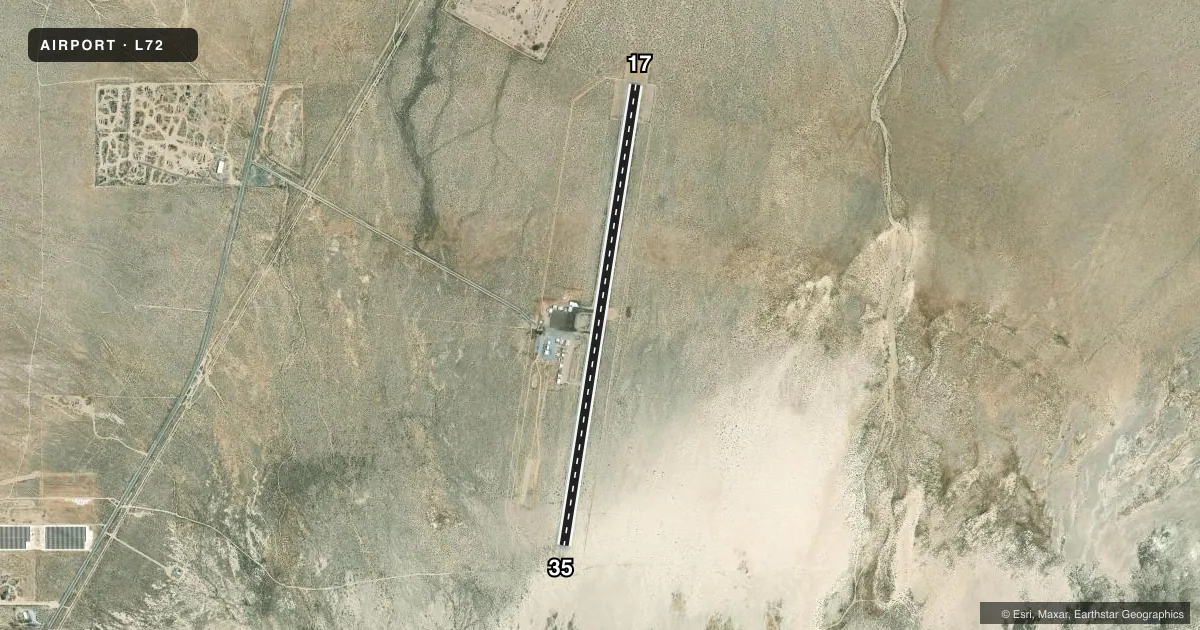
Airport sketch
Runways drawn to scale from FAA survey coordinates, rendered over satellite imagery. Not for navigation.
Approaches & charts
Services on the field
Fuel grades, oxygen, maintenance, ramp storage and lighting — as declared to the FAA by the airport operator.
Fuel & services
- Fuel
- Not available
- Oxygen (bottled)
- Not available
- Oxygen (bulk)
- Not available
- Airframe repair
- Not available
- Power plant repair
- Not available
Ramp & ground
- Transient storage
- Tie-down
- Landing fee
- No fee published
- Customs
- Not available
- Lighting schedule
- SEE RMK
- Beacon schedule
- SS-SR
- Beacon
- White / Green (civil land)(WG)
- Wind indicator
- Lighted
- Segmented circle
- Yes
Fuel & FBOs
Cheapest 100LL and Jet A on the field and nearby. Always confirm with the FBO before taxi.
Airport notes
Surface conditions, obstructions, local procedures, lighting outages and other notes published with each FAA cycle.
General notes
- HELIPAD H1 IS LOCATED 230 FEET WEST OF RY 17/35 AND 3,380 FT SOUTH OF RY 17 THLD.
- FOR CD CTC JOSHUA APCH AT 661-277-3843.
Lighting notes
- ACTVT LIRL RY 17/35 (5) CLICKS ON FREQ - 122.8.
Runway surface & condition
- 17/35NSTD LIRL EDGE LIGHTS 55 FT FM EDGES OF RY.
Approach & departure obstructions
- 17TAXI & HOLD LINE MRKG ARE BARELY VSB.
- 35TAXI & HOLD LINE MRKG ARE BARELY VSB.
Other notes
- ESTABD PRIOR TO 5/15/59.
- MANAGERARPT MGR/CARETAKERS: GEORGE & BETH BASS 928-592-3427
VFR map & nearby airports
VFR sectional. Tap any ICAO chip to open that airport.
Key facts · L72
Answer card- ICAO
- L72
- Name
- TRONA
- Location
- TRONA, CALIFORNIA
- Elevation
- 1,717.8 ft MSL
- Traffic pattern altitude
- 2,717.8 ft MSL (1,000 AGL)
- Control tower
- Non-towered (use CTAF)
- Total runways
- 1
- Longest runway
- 17/35 · 5,910 ft
- Published ILS approaches
- 0
- Published frequencies
- 1
- Magnetic variation
- 14°
- Current flight rules
- VFR
- Current wind
- 280° at 19 kt
- Favored runway now
- RWY 35
Trona Airport is in Trona, California. The field elevation is 1,717.8 ft MSL. It has one runway, 17/35, which is 5,910 ft long and asphalt. There is no control tower. No ILS approaches are published. Pattern altitude is not published. Use the standard 1,000 ft AGL pattern for light piston traffic unless current local guidance says otherwise.
The runway lighting is low intensity. Published remarks say the lights on 17/35 are activated by clicking 122.8 five times. Taxi and hold line markings are barely visible on both runway ends. Plan your ground movement carefully. The airport also has a helipad, H1, located west of the runway. The airport manager and caretakers are George and Beth Bass. Their phone number is published in the Chart Supplement.
For a first-time arrival, the main things to verify are runway lighting use, surface markings and any local coordination needed for clearance delivery. CTAF is 122.9. The airport is not towered, so expect self-announce traffic. Check the current FAA Chart Supplement for any updated remarks before you go.