METAR & TAF L05
L05 does not publish a METAR.
Showing the nearest reporting station: KTSP (TEHACHAPI MUNI) · 35.6 NM away. Conditions at L05 may differ.
METAR · KTSP
Observed 21:55Z
KTSP 262155Z AUTO 32015KT 10SM CLR 29/05 A3015 RMK AO2
- Wind
- 320° @ 15 kt
- Visibility
- 10 SM
- Temp / Dew
- 29°C / 5°C
- Altimeter
- 30.15 inHg
- Clouds
- CLR
- Density alt
- 4,636 ft
- Ceiling
- Unlimited
- Rules
- VFR
Airport info & contacts
Manager on record, flight service, ARTCC, attendance schedule and pattern altitude — published by the FAA and refreshed every 28 days.
Location
- From city
- 3 NM S
- VFR sectional
- LOS ANGELES
- ARTCC
- ZLA · LOS ANGELES
- NOTAM facility
- RIU (NOTAM-D)
Airport manager
- Name
- BILL LAMANQUE
- Phone
- 661-391-1824
- Address
- 3701 WINGS WAY, SUITE 300, BAKERSFIELD CA 93308-7026
Flight service · Hours
- FSS RIU
- RANCHO MURIETA1-800-WX-BRIEF
- Attendance
- DALGT
Frequencies
Tap any row to copy the frequency to your clipboard.
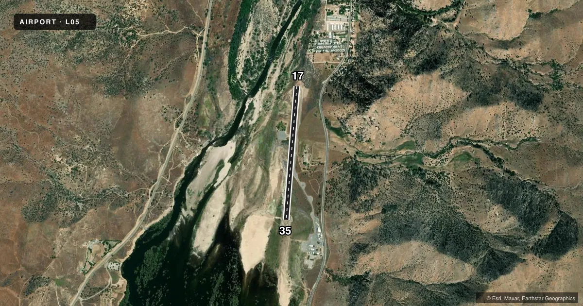
Runways & pattern
Full pagePattern entry · RWY 35
LEFT TRAFFICRunway end performance
| End | TORA | TODA | ASDA | LDA | VGSI | Approach lights | Obstruction |
|---|---|---|---|---|---|---|---|
| 17 | — | — | — | — | — | — | 36', trees, 920' from thr, 200' R of cntrln, slope 19 |
Declared distances in feet. TORA = takeoff run available, TODA = takeoff distance, ASDA = accelerate-stop, LDA = landing distance.
Airport sketch
Runways drawn to scale from FAA survey coordinates, rendered over satellite imagery. Not for navigation.
Approaches & charts
Services on the field
Fuel grades, oxygen, maintenance, ramp storage and lighting — as declared to the FAA by the airport operator.
Fuel & services
- Fuel
- Not available
- Oxygen (bottled)
- Not available
- Oxygen (bulk)
- Not available
- Airframe repair
- Minor
- Power plant repair
- Minor
- Other services
- INSTR,RNTL
Ramp & ground
- Transient storage
- Tie-down
- Landing fee
- No fee published
- Customs
- Not available
- Wind indicator
- Yes
- Segmented circle
- Yes
Fuel & FBOs
Cheapest 100LL and Jet A on the field and nearby. Always confirm with the FBO before taxi.
Airport notes
Surface conditions, obstructions, local procedures, lighting outages and other notes published with each FAA cycle.
General notes
- <NO NIGHT OPERATIONS.
- FLY-IN CAMPGROUND ON ARPT.
- FOR CD CTC JOSHUA APCH AT 661-277-3843.
Runway surface & condition
- 17/35GROSS RWY PAVEMENT STRENGTH ESTIMATE PRVDD BY ARPT MANAGER; 12500 LBS.
Approach & departure obstructions
- 35GTR THAN 1 FT ROCKS 0-90 FT FM EOR 50 FT LEFT TO 80 FT RIGHT PRVDG WASHOUT PROTECTION FM LAKE.
Other notes
- MANAGERDIRECTOR, KERN COUNTY AIRPORTS
- OWNEROWNED BY US FOREST SVC ON LEASE TO KERN COUNTY.
- MANAGER24 HR EMERG PHONE 661-747-4055.
VFR map & nearby airports
VFR sectional. Tap any ICAO chip to open that airport.
Key facts · L05
Answer card- ICAO
- L05
- Name
- KERN VALLEY
- Location
- KERNVILLE, CALIFORNIA
- Elevation
- 2,614 ft MSL
- Traffic pattern altitude
- 3,614 ft MSL (1,000 AGL)
- Control tower
- Non-towered (use CTAF)
- Total runways
- 1
- Longest runway
- 17/35 · 3,500 ft
- Published ILS approaches
- 0
- Published frequencies
- 2
- Magnetic variation
- 14°
- Current flight rules
- VFR
- Current wind
- 320° at 15 kt
- Favored runway now
- RWY 35
Kern Valley Airport sits in Kernville, California at 2,614 ft MSL. It has one runway. Runway 17/35 is 3,500 ft long and asphalt. There is no control tower. CTAF and UNICOM are both 122.8. No ILS approaches are published for the field.
The published pattern altitude is not listed, so use the standard 1,000 ft AGL unless the current Chart Supplement says otherwise. That puts the light piston pattern at about 3,614 ft MSL. The field is in a mountain and lake setting, so expect terrain and density altitude to matter on warm days. The runway 35 end has rocks near the departure area that help with washout protection from the lake. The airport manager also reports a gross pavement strength estimate of 12,500 pounds.
There are no on-field FBOs listed. Check with the airport operator or the FBO directly by phone before arrival if you need fuel or services. Published remarks also say no night operations are permitted. The airport has a fly-in campground. For clearance delivery, contact Joshua Approach at 661-277-3843. If you are planning a first stop here, verify current procedures in the FAA Chart Supplement before you go.