METAR & TAF L80
L80 does not publish a METAR.
Showing the nearest reporting station: KPTV (PORTERVILLE MUNI) · 44.4 NM away. Conditions at L80 may differ.
METAR · KPTV
Observed 08:56Z
KPTV 270856Z AUTO 28004KT 10SM CLR 22/13 A2994 RMK AO2 SLP136 T02220133 52003 $
- Wind
- 280° @ 4 kt
- Visibility
- 10 SM
- Temp / Dew
- 22°C / 13°C
- Altimeter
- 29.94 inHg
- Clouds
- CLR
- Density alt
- 10,579 ft
- Ceiling
- Unlimited
- Rules
- VFR
Airport info & contacts
Manager on record, flight service, ARTCC, attendance schedule and pattern altitude — published by the FAA and refreshed every 28 days.
Location
- From city
- 24 NM S
- VFR sectional
- SAN FRANCISCO
- ARTCC
- ZLA · LOS ANGELES
- NOTAM facility
- RAL (NOTAM-D)
Airport manager
- Name
- TAWNY MELVILLE
- Phone
- 707-980-4383
- Address
- 640 S. MAIN STREET, P.O. BOX 8, LONE PINE CA 93545
Flight service · Hours
- FSS RAL
- RIVERSIDE1-800-WX-BRIEF
- Attendance
- Unattended
Frequencies
Tap any row to copy the frequency to your clipboard.
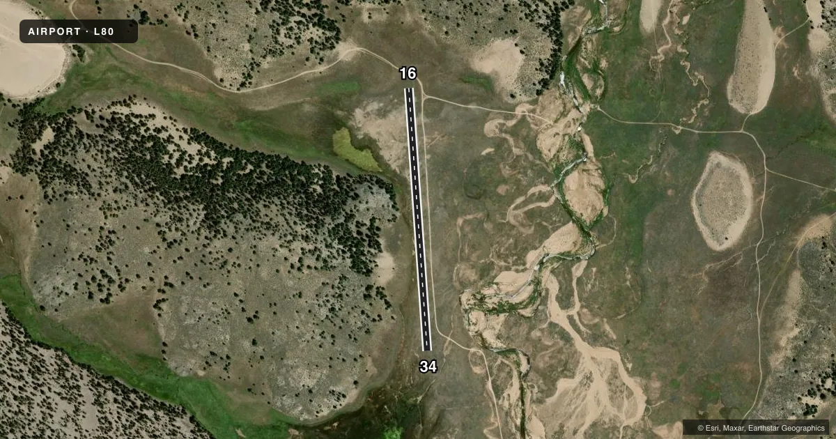
Runways & pattern
Full pagePattern entry · RWY 34
RIGHT TRAFFICAirport sketch
Runways drawn to scale from FAA survey coordinates, rendered over satellite imagery. Not for navigation.
Approaches & charts
Services on the field
Fuel grades, oxygen, maintenance, ramp storage and lighting — as declared to the FAA by the airport operator.
Fuel & services
- Fuel
- Not available
Ramp & ground
- Transient storage
- Not published
Fuel & FBOs
Cheapest 100LL and Jet A on the field and nearby. Always confirm with the FBO before taxi.
Airport notes
Surface conditions, obstructions, local procedures, lighting outages and other notes published with each FAA cycle.
VFR map & nearby airports
VFR sectional. Tap any ICAO chip to open that airport.
Key facts · L80
Answer card- ICAO
- L80
- Name
- MONACHE MEADOWS
- Location
- LONE PINE, CALIFORNIA
- Elevation
- 7,874 ft MSL
- Traffic pattern altitude
- 8,874 ft MSL (1,000 AGL)
- Control tower
- Non-towered (use CTAF)
- Total runways
- 1
- Longest runway
- 16/34 · 2,383 ft
- Published ILS approaches
- 0
- Published frequencies
- 0
- Magnetic variation
- 15°
- Current flight rules
- VFR
- Current wind
- 280° at 4 kt
- Favored runway now
- RWY 34
Monache Meadows is in Lone Pine, California. The field elevation is 7,874 ft MSL. It has one runway, 16/34, which is 2,383 ft long and surfaced turf-dirt. The airport is not towered. No ILS approaches are published.
For pattern work, the published pattern altitude is not listed. Use the standard 1,000 ft AGL assumption for light piston operations unless the current FAA Chart Supplement says otherwise. That puts you in high-elevation mountain-country operating conditions. Expect performance to matter. Density altitude can be a real factor here, especially on warm days. The runway is short. Plan conservatively and leave margin for go-arounds.
There are no on-field FBOs listed in the facts, so verify current services with the airport operator or call the field directly before arrival. There are also no published remarks in the provided data. If you need current operational details, check the current FAA Chart Supplement before flying in.