METAR & TAF O26
Current METAR
Observed 07:35Z
KO26 270735Z AUTO 00000KT 10SM CLR 20/05 A3005 RMK A01
- Wind
- 000° @ 0 kt
- Visibility
- 10 SM
- Temp / Dew
- 20°C / 5°C
- Altimeter
- 30.05 inHg
- Clouds
- CLR
- Density alt
- 5,039 ft
- Ceiling
- Unlimited
- Rules
- VFR
Airport info & contacts
Manager on record, flight service, ARTCC, attendance schedule and pattern altitude — published by the FAA and refreshed every 28 days.
Location
- From city
- 1 NM SE
- VFR sectional
- SAN FRANCISCO
- Pattern altitude
- 800 ft AGL · 4,510 ft MSL
- ARTCC
- ZLA · LOS ANGELES
- NOTAM facility
- RAL (NOTAM-D)
Airport manager
- Name
- ASHLEY HELMS
- Phone
- 760-872-2971
- Address
- 703 AIRPORT ROAD, BISHOP CA 93514
Flight service · Hours
- FSS RAL
- RIVERSIDE1-800-WX-BRIEF
- Attendance
- IREG
Frequencies
Tap any row to copy the frequency to your clipboard.
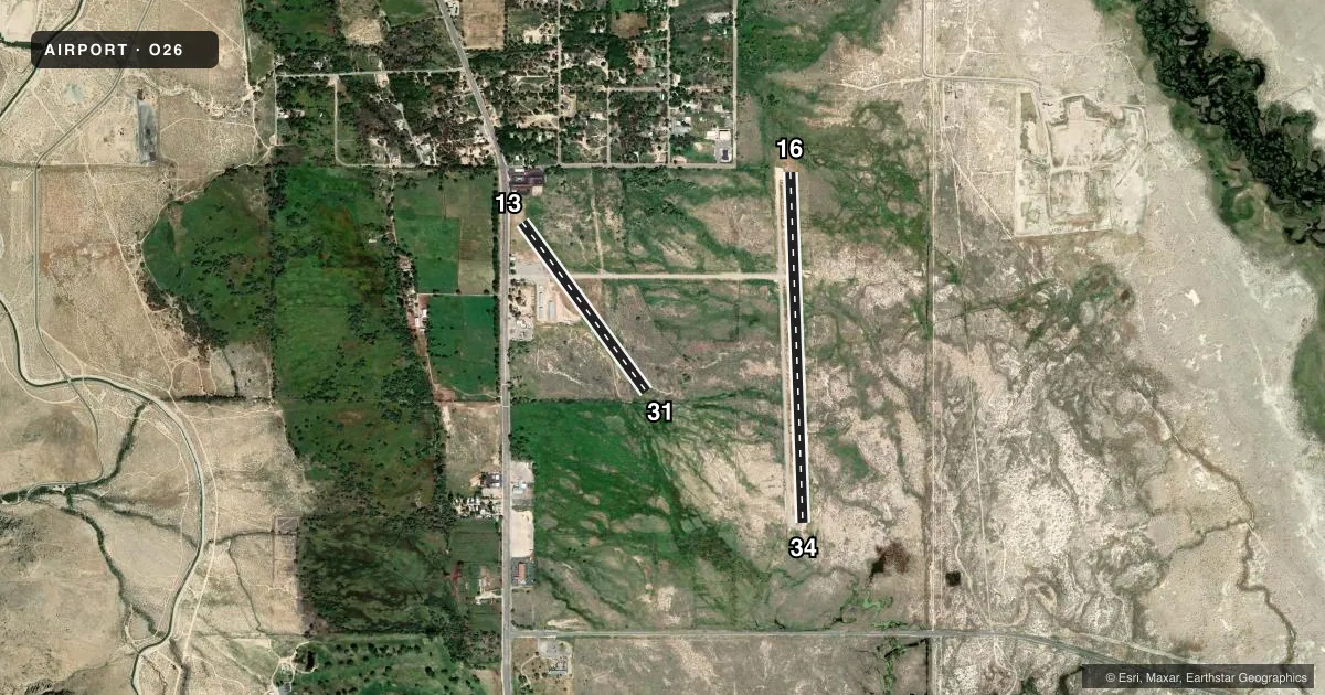
Runways & pattern
Full pagePattern entry · RWY 16
LEFT TRAFFIC| Runway | Heading (°M) | Length | Surface | Traffic |
|---|---|---|---|---|
| 16/34 | 162° / 342° | 3,991 ft | ASPH | 34 R |
| 13/31 | 129° / 308° | 2,391 ft | DIRT | 13 R |
Runway end performance
| End | TORA | TODA | ASDA | LDA | VGSI | Approach lights | Obstruction |
|---|---|---|---|---|---|---|---|
| 16 | — | — | — | — | — | — | 40', tree, 1300' from thr, 100' R of cntrln, slope 27 |
| 34 | — | — | — | — | — | — | 4', fence, 315' from thr, 0' R of cntrln, slope 28 |
| 13 | — | — | — | — | — | — | 40', trees, 85' from thr, 205' R of cntrln, slope 2 |
| 31 | — | — | — | — | — | — | 3', fence, 100' from thr, 50' R of cntrln, slope 33 |
Declared distances in feet. TORA = takeoff run available, TODA = takeoff distance, ASDA = accelerate-stop, LDA = landing distance.
Airport sketch
Runways drawn to scale from FAA survey coordinates, rendered over satellite imagery. Not for navigation.
Approaches & charts
Services on the field
Fuel grades, oxygen, maintenance, ramp storage and lighting — as declared to the FAA by the airport operator.
Fuel & services
- Fuel
- 100LLA
- Other services
- PAJA
Ramp & ground
- Transient storage
- Tie-down
- Landing fee
- No fee published
- Customs
- Not available
- Lighting schedule
- SEE RMK
- Beacon schedule
- SEE RMK
- Beacon
- White / Green (civil land)(WG)
- Wind indicator
- Lighted
- Segmented circle
- Yes
Fuel & FBOs
Cheapest 100LL and Jet A on the field and nearby. Always confirm with the FBO before taxi.
Airport notes
Surface conditions, obstructions, local procedures, lighting outages and other notes published with each FAA cycle.
General notes
- HANG GLDR AND SKYDIVING ACT IN VICINTY OF ARPT.
- RY 13/31 RSTD TO GLIDERS ONLY EXCEPT PPR - CTAF.
- HELICOPTER TFC APCH ARPT FM EAST ALONG TWY TO HELIPAD.
- PILOTS BE ALERT TO PSBL WIND SHEAR OVER TREES WHILE ON APCH RY 16 WITH SE WINDS 15 KTS OR GTR.
- TWR LCTD 2700 FT NW RY 16 APCH END, (136 AGL) 3717 MSL, UNLGTD.
- FOR CD CTC JOSHUA APCH AT 661-277-3843.
Lighting notes
- ACTVT BCN - CTAF.
- ACTVT MIRL RY 16/34 - CTAF.
Fuel notes
- 100LLFUEL 100LL AVBL 24 HRS BY CREDIT CARD.
- AFUEL JET A LTD; MUST MAKE PRIOR ARNGMTS WITH FUEL PRVDR 760-872-2971.
Approach & departure obstructions
- 1313G/31G NO NRS; THRS & DSPLCD THR RY 13G MKD WITH TIRES PAINTED WHITE; WHITE R'S BOTH ENDS OF RY LEFT SIDE.
- 13APCH RATIO 20:1 TO DSPLCD THLD. THLD ACTUALLY DSPLCD 625 FEET.
Other notes
- ESTABD PRIOR 5/15/59.
- OWNERLEASED & MNTND BY INYO CO PUBLIC WORKS, 760-872-2971
- MANAGER168 N EDWARDS ST, INDEPENDENCE, CA
VFR map & nearby airports
VFR sectional. Tap any ICAO chip to open that airport.
Key facts · O26
Answer card- ICAO
- O26
- Name
- LONE PINE/DEATH VALLEY
- Location
- LONE PINE, CALIFORNIA
- Elevation
- 3,709.8 ft MSL
- Traffic pattern altitude
- 4,509.8 ft MSL (800 AGL)
- Control tower
- Non-towered (use CTAF)
- Total runways
- 2
- Longest runway
- 16/34 · 3,991 ft
- Published ILS approaches
- 0
- Published frequencies
- 2
- Magnetic variation
- 15°
- Current flight rules
- VFR
- Current wind
- 000° at 0 kt
- Favored runway now
- –
Lone Pine/Death Valley Airport (O26) sits in Lone Pine, California. The field elevation is 3,709.8 ft MSL. It has two runways. The longest is runway 16/34 at 3,991 ft. There is no control tower. CTAF and UNICOM are both 122.8. No ILS approaches are published here.
The pattern altitude is 800 ft AGL, which is 4,509.8 ft MSL. Lone Pine Airport is on the field. It carries 100LL, Jet A and Jet A Prist. Jet A is limited. Prior arrangements are required with the fuel provider by phone. The airport is leased and maintained by Inyo County Public Works. The airport beacon is activated by CTAF. Medium intensity runway lights on 16/34 are also activated by CTAF.
First-time pilots should pay close attention to the terrain and the published remarks. Runway 13/31 is restricted to gliders only unless prior permission is obtained on CTAF. The approach to runway 16 can see wind shear over trees when southeast winds reach 15 knots or more. The tower north of the field is unlighted and sits northwest of runway 16. Hang glider and skydiving activity also occurs nearby. Check the current FAA Chart Supplement before departure for any current operating notes.