METAR & TAF KWJF
Current METAR
Observed 07:56Z
KWJF 270756Z AUTO 26012KT 10SM CLR 27/05 A3000 RMK AO2 SLP130 T02670050 403890239 $
- Wind
- 260° @ 12 kt
- Visibility
- 10 SM
- Temp / Dew
- 27°C / 5°C
- Altimeter
- 30.00 inHg
- Clouds
- CLR
- Density alt
- 4,256 ft
- Ceiling
- Unlimited
- Rules
- VFR
Airport info & contacts
Manager on record, flight service, ARTCC, attendance schedule and pattern altitude — published by the FAA and refreshed every 28 days.
Location
- From city
- 4 NM NW
- VFR sectional
- LOS ANGELES
- Pattern altitude
- 800 ft AGL · 3,151 ft MSL
- ARTCC
- ZLA · LOS ANGELES
- NOTAM facility
- WJF (NOTAM-D)
Airport manager
- Name
- ADAM SIKORSKI
- Phone
- 661-945-0078
- Address
- 4725 WILLIAM J BARNES AVE, LANCASTER CA 93536
Flight service · Hours
- FSS RAL
- RIVERSIDE1-800-WX-BRIEF
- Attendance
- ALL
Frequencies
Tap any row to copy the frequency to your clipboard.
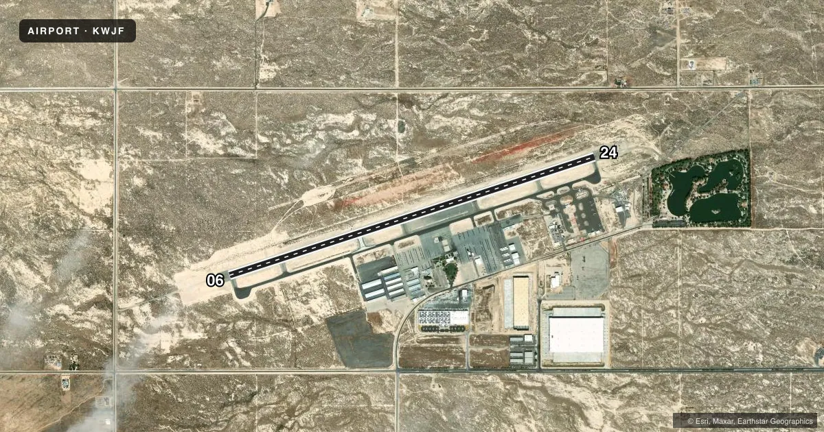
Runways & pattern
Full pagePattern entry · RWY 24
RIGHT TRAFFICRunway end performance
| End | TORA | TODA | ASDA | LDA | VGSI | Approach lights | Obstruction |
|---|---|---|---|---|---|---|---|
| 06 | — | — | — | — | PAPI 4-box left(3°) | — | — |
| 24 | — | — | — | — | PAPI 4-box left(3°) | — | — |
Declared distances in feet. TORA = takeoff run available, TODA = takeoff distance, ASDA = accelerate-stop, LDA = landing distance.
Airport sketch
Runways drawn to scale from FAA survey coordinates, rendered over satellite imagery. Not for navigation.
Approaches & charts
Services on the field
Fuel grades, oxygen, maintenance, ramp storage and lighting — as declared to the FAA by the airport operator.
Fuel & services
- Fuel
- 100LLA
- Oxygen (bottled)
- Not available
- Oxygen (bulk)
- Low pressure
- Airframe repair
- Major
- Power plant repair
- Major
- Other services
- AVNCS,CHTR,INSTR,RNTL,SALES
Ramp & ground
- Transient storage
- Tie-down
- Landing fee
- No fee published
- Customs
- Not available
- Lighting schedule
- SEE RMK
- Beacon schedule
- SS-SR
- Beacon
- White / Green (civil land)(WG)
- Wind indicator
- Lighted
- Segmented circle
- Yes
Fuel & FBOs
Cheapest 100LL and Jet A on the field and nearby. Always confirm with the FBO before taxi.
Airport notes
Surface conditions, obstructions, local procedures, lighting outages and other notes published with each FAA cycle.
General notes
- <LGTD RDO TWRS 4 MI SE.
- FOREST SVC FIRE FIGHTING STN ON ARPT MAY-DEC.
- NUMEROUS BIRDS SE OF ARPT.
- PAEW ADJACENT RAMP AREA BTN FUEL ISLAND AND TERMINAL BLDG.
Lighting notes
- ARPT LGTS ON CONTINUOUSLY, WHEN ATCT CLSD.
Other notes
- THIS AIRPORT HAS BEEN SURVEYED BY THE NATIONAL GEODETIC SURVEY.
- OWNERLA COUNTY CTC: PAUL MASELBAS, 626-300-4600 X4615.
VFR map & nearby airports
VFR sectional. Tap any ICAO chip to open that airport.
Key facts · KWJF
Answer card- ICAO
- KWJF
- Name
- GENERAL WM J FOX AIRFIELD
- Location
- LANCASTER, CALIFORNIA
- Elevation
- 2,350.7 ft MSL
- Traffic pattern altitude
- 3,150.7 ft MSL (800 AGL)
- Control tower
- Towered · 0700-2100
- Total runways
- 1
- Longest runway
- 06/24 · 7,201 ft
- Published ILS approaches
- 0
- Published frequencies
- 9
- Magnetic variation
- 15°
- Current flight rules
- VFR
- Current wind
- 260° at 12 kt
- Favored runway now
- RWY 24
General WM J Fox Airfield sits in Lancaster, California at 2,350.7 ft MSL. It has one runway, 06/24, which is 7,201 ft long. The airport is towered from 0700 to 2100. Outside those hours, airport lights stay on continuously. Pattern altitude is 800 ft AGL, or 3,150.7 ft MSL. No ILS approaches are published here. Plan with the current FAA Chart Supplement and the current approach chart set before you go.
MH Fuels is on the field. It carries 100LL, Jet A and Jet A Prist. Call them at (661) 499-5493 for current service details. The airport sits in the Lancaster area of the high desert. Density altitude can matter, especially in warmer weather. The published remarks also note a Forest Service fire fighting station on the airport from May through December. Lighted radio towers are 4 miles southeast. Numerous birds are present southeast of the airport. Keep a sharp scan on departure and arrival.
For ground movement, the parking area is adjacent to the ramp between the fuel island and the terminal building. If you need local airport contact information for operational questions, the published remarks list Paul Maselbas for Los Angeles County at 626-300-4600 extension 4615.