METAR & TAF KTLR
KTLR does not publish a METAR.
Showing the nearest reporting station: KVIS (VISALIA MUNI) · 10.2 NM away. Conditions at KTLR may differ.
METAR · KVIS
Observed 09:56Z
KVIS 270956Z AUTO 31007KT 10SM CLR 22/13 A2993 RMK AO2 SLP131 T02170128 $
- Wind
- 310° @ 7 kt
- Visibility
- 10 SM
- Temp / Dew
- 22°C / 13°C
- Altimeter
- 29.93 inHg
- Clouds
- CLR
- Density alt
- 1,157 ft
- Ceiling
- Unlimited
- Rules
- VFR
Airport info & contacts
Manager on record, flight service, ARTCC, attendance schedule and pattern altitude — published by the FAA and refreshed every 28 days.
Location
- From city
- 3 NM SE
- VFR sectional
- SAN FRANCISCO
- ARTCC
- ZOA · OAKLAND
- NOTAM facility
- RIU (NOTAM-D)
Airport manager
- Name
- PETER ARANZARU
- Phone
- 559-684-4329
- Address
- 3981 SOUTH K STREET, TULARE CA 93274
Flight service · Hours
- FSS RIU
- RANCHO MURIETA1-800-WX-BRIEF
- Attendance
- 0800-DUSK
Frequencies
Tap any row to copy the frequency to your clipboard.
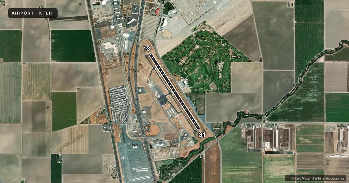
Runways & pattern
Full pagePattern entry · RWY 31
LEFT TRAFFICRunway end performance
| End | TORA | TODA | ASDA | LDA | VGSI | Approach lights | Obstruction |
|---|---|---|---|---|---|---|---|
| 13 | — | — | — | — | PAPI 2-box left(3°) | — | 15', road, 500' from thr, 295' R of cntrln, slope 20 |
| 31 | — | — | — | — | PAPI 2-box left(3°) | — | — |
Declared distances in feet. TORA = takeoff run available, TODA = takeoff distance, ASDA = accelerate-stop, LDA = landing distance.
Airport sketch
Runways drawn to scale from FAA survey coordinates, rendered over satellite imagery. Not for navigation.
Approaches & charts
Services on the field
Fuel grades, oxygen, maintenance, ramp storage and lighting — as declared to the FAA by the airport operator.
Fuel & services
- Fuel
- 100LLA
- Oxygen (bottled)
- Not available
- Oxygen (bulk)
- Not available
- Other services
- AGRI,AVNCS,CHTR,INSTR,RNTL
Ramp & ground
- Transient storage
- Tie-down
- Landing fee
- No fee published
- Customs
- Not available
- Lighting schedule
- SEE RMK
- Beacon schedule
- SS-SR
- Beacon
- White / Green (civil land)(WG)
- Wind indicator
- Lighted
- Segmented circle
- Yes
Fuel & FBOs
Cheapest 100LL and Jet A on the field and nearby. Always confirm with the FBO before taxi.
Airport notes
Surface conditions, obstructions, local procedures, lighting outages and other notes published with each FAA cycle.
General notes
- FOR CD CTC FRESNO APCH AT 559-454-9805.
Lighting notes
- ACTVT MIRL RWY 13/31 - CTAF. PAPI 13 OPRS CONSLY.
Approach & departure obstructions
- 13UNUSBL BYD 7 DEG R OF CNTRLN.
Other notes
- THIS AIRPORT HAS BEEN SURVEYED BY THE NATIONAL GEODETIC SURVEY.
VFR map & nearby airports
VFR sectional. Tap any ICAO chip to open that airport.
Key facts · KTLR
Answer card- ICAO
- KTLR
- Name
- MEFFORD FLD
- Location
- TULARE, CALIFORNIA
- Elevation
- 265.3 ft MSL
- Traffic pattern altitude
- 1,265.3 ft MSL (1,000 AGL)
- Control tower
- Non-towered (use CTAF)
- Total runways
- 1
- Longest runway
- 13/31 · 3,901 ft
- Published ILS approaches
- 0
- Published frequencies
- 4
- Magnetic variation
- 12°
- Current flight rules
- VFR
- Current wind
- 310° at 7 kt
- Favored runway now
- RWY 31
Mefford Field sits in Tulare, California. Field elevation is 265.3 ft MSL. The airport has one runway. Runway 13/31 is 3,901 ft of asphalt. There is no control tower. Fresno Approach handles clearance delivery. The published CTAF and UNICOM are both 122.7.
No ILS approaches are published here. The runway lights on 13/31 are activated by CTAF. The PAPI for runway 13 operates continuously. The visual glide slope indicator for runway 13 is unusable beyond 7 degrees right of centerline, so keep that in mind on final. Pattern altitude is not published. Use the standard 1,000 ft AGL pattern unless current local guidance says otherwise. That puts the light piston pattern at 1,265.3 ft MSL.
Valley Air Crafts is on the field. It carries 100LL and Jet A. For a first visit, plan for a non-towered airport with Fresno Approach support on the clearance side. The field is in the Central Valley, so density altitude can still matter on warm days. Check the current Chart Supplement for any local procedures before you go. The airport has also been surveyed by the National Geodetic Survey.