METAR & TAF 0Q4
0Q4 does not publish a METAR.
Showing the nearest reporting station: KFCH (FRESNO CHANDLER EXEC) · 12.0 NM away. Conditions at 0Q4 may differ.
METAR · KFCH
Observed 10:55Z
KFCH 271055Z AUTO 32008KT 10SM CLR 21/09 A2994 RMK A01
- Wind
- 320° @ 8 kt
- Visibility
- 10 SM
- Temp / Dew
- 21°C / 9°C
- Altimeter
- 29.94 inHg
- Clouds
- CLR
- Density alt
- 1,073 ft
- Ceiling
- Unlimited
- Rules
- VFR
Airport info & contacts
Manager on record, flight service, ARTCC, attendance schedule and pattern altitude — published by the FAA and refreshed every 28 days.
Location
- From city
- 2 NM NW
- VFR sectional
- SAN FRANCISCO
- Pattern altitude
- 800 ft AGL · 1,105 ft MSL
- ARTCC
- ZOA · OAKLAND
- NOTAM facility
- RIU (NOTAM-D)
Airport manager
- Name
- LESLIE DELLAHUNDY
- Phone
- 559-287-8401
- Address
- 7225 E HUNTSMAN AVE., SELMA CA 93662
Flight service · Hours
- FSS RIU
- RANCHO MURIETA1-800-WX-BRIEF
- Attendance
- UNATTND
Frequencies
Tap any row to copy the frequency to your clipboard.
Runways & pattern
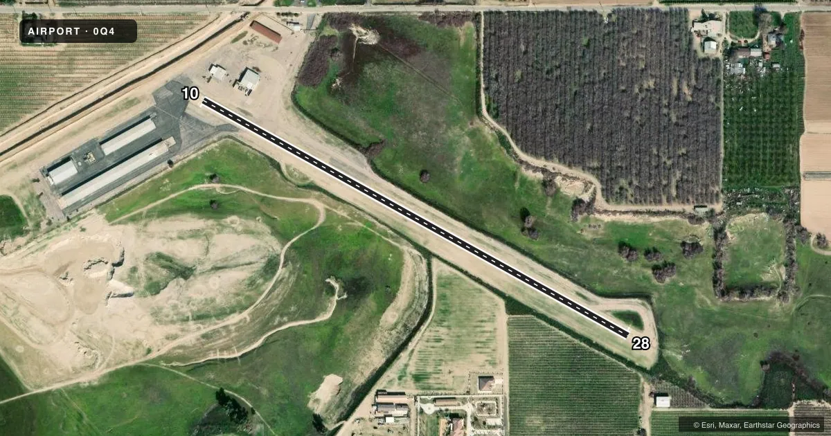
Full pagePattern entry · RWY 28
LEFT TRAFFICRunway end performance
| End | TORA | TODA | ASDA | LDA | VGSI | Approach lights | Obstruction |
|---|---|---|---|---|---|---|---|
| 10 | — | — | — | — | — | — | 40', trees, 750' from thr, 20' R of cntrln, slope 13 |
| 28 | — | — | — | — | — | — | 6', berm, 325' from thr, 100' R of cntrln, slope 20 |
Declared distances in feet. TORA = takeoff run available, TODA = takeoff distance, ASDA = accelerate-stop, LDA = landing distance.
Airport sketch
Runways drawn to scale from FAA survey coordinates, rendered over satellite imagery. Not for navigation.
Approaches & charts
Services on the field
Fuel grades, oxygen, maintenance, ramp storage and lighting — as declared to the FAA by the airport operator.
Fuel & services
- Fuel
- 100LL
- Oxygen (bottled)
- Not available
- Oxygen (bulk)
- Not available
- Airframe repair
- Not available
- Power plant repair
- Not available
Ramp & ground
- Transient storage
- Tie-down
- Landing fee
- No fee published
- Customs
- Not available
- Lighting schedule
- SEE RMK
- Beacon schedule
- SEE RMK
- Beacon
- White / Green (civil land)(WG)
- Wind indicator
- Lighted
- Segmented circle
- No
Fuel & FBOs
Cheapest 100LL and Jet A on the field and nearby. Always confirm with the FBO before taxi.
Airport notes
Surface conditions, obstructions, local procedures, lighting outages and other notes published with each FAA cycle.
General notes
- ARPT CLSD TO HELS EXC PPR 559-287-4900 OR 539-314-4900.
- FOR CD CTC FRESNO APCH AT 559-454-9805.
Lighting notes
- DUSK-0100. PPR FOR ROTG BCN AFTER 0100. CALL (559) 896-1001 DURING ATTENDANT HOURS.
- LIRL RWY 10/28 ON DUSK-0100.
Approach & departure obstructions
- 28+10 FT BERM 0-200 FT FM RY END & 100 FT L.
VFR map & nearby airports
VFR sectional. Tap any ICAO chip to open that airport.
Key facts · 0Q4
Answer card- ICAO
- 0Q4
- Name
- SELMA
- Location
- SELMA, CALIFORNIA
- Elevation
- 305 ft MSL
- Traffic pattern altitude
- 1,105 ft MSL (800 AGL)
- Control tower
- Non-towered (use CTAF)
- Total runways
- 1
- Longest runway
- 10/28 · 2,206 ft
- Published ILS approaches
- 0
- Published frequencies
- 2
- Magnetic variation
- 15°
- Current flight rules
- VFR
- Current wind
- 320° at 8 kt
- Favored runway now
- RWY 28
SELMA (0Q4) is in Selma, California. The field elevation is 305 ft MSL. It has one runway, 10/28, which is 2,206 ft long and paved with asphalt. There is no control tower. Pattern altitude is 800 ft AGL, which is 1,105 ft MSL.
No ILS approaches are published here. CTAF and UNICOM are both 122.8. Selma Aerodrome is on the field. It carries AVGAS 100LL. Call (559) 896-1001 for current service details.
A few published remarks matter for planning. The rotating beacon runs from dusk to 0100. After 0100, prior permission is required for beacon use. Low intensity runway lights on 10/28 also run from dusk to 0100. Runway 10/28 has pavement cracking along its full length. Runway 28 also has a 10 ft berm near the departure end, about 0 to 200 ft from the end and 100 ft left of centerline. The airport is closed to helicopters unless you have prior permission. For clearance delivery, contact Fresno Approach at 559-454-9805.
This is a small non-towered field with a short runway. Plan your performance carefully, especially on warm days. The published pattern altitude and runway condition notes are the main items a first-time pilot should review before arrival.