METAR & TAF KFCH
Current METAR
Observed 07:35Z
KFCH 270735Z AUTO 31010KT 10SM CLR 24/13 A2995 RMK A01
- Wind
- 310° @ 10 kt
- Visibility
- 10 SM
- Temp / Dew
- 24°C / 13°C
- Altimeter
- 29.95 inHg
- Clouds
- CLR
- Density alt
- 1,390 ft
- Ceiling
- Unlimited
- Rules
- VFR
Airport info & contacts
Manager on record, flight service, ARTCC, attendance schedule and pattern altitude — published by the FAA and refreshed every 28 days.
Location
- From city
- 2 NM W
- VFR sectional
- SAN FRANCISCO
- ARTCC
- ZOA · OAKLAND
- NOTAM facility
- FCH (NOTAM-D)
Airport manager
- Name
- FRANCISCO PARTIDA
- Phone
- 559-621-4531
- Address
- 510 WEST KEARNEY BLVD, FRESNO CA 93706
Flight service · Hours
- FSS RIU
- RANCHO MURIETA1-800-WX-BRIEF
- Attendance
- 0800-1700
Frequencies
Tap any row to copy the frequency to your clipboard.
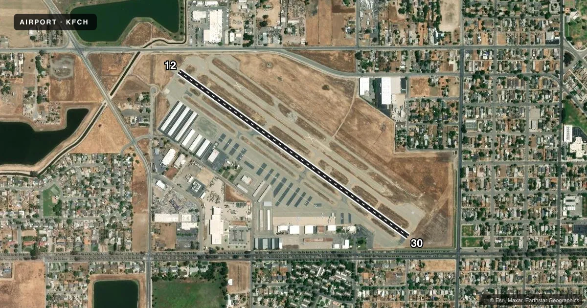
Runways & pattern
Full pagePattern entry · RWY 30
LEFT TRAFFICRunway end performance
| End | TORA | TODA | ASDA | LDA | VGSI | Approach lights | Obstruction |
|---|---|---|---|---|---|---|---|
| 12 | — | — | — | — | PAPI 2-box left(3°) | — | 15', road, 450' from thr, 150' R of cntrln, slope 16 |
| 30 | — | — | — | — | PAPI 4-box right(3°) | — | 15', road, 360' from thr, 140' R of cntrln, slope 10 |
Declared distances in feet. TORA = takeoff run available, TODA = takeoff distance, ASDA = accelerate-stop, LDA = landing distance.
Airport sketch
Runways drawn to scale from FAA survey coordinates, rendered over satellite imagery. Not for navigation.
Approaches & charts
Services on the field
Fuel grades, oxygen, maintenance, ramp storage and lighting — as declared to the FAA by the airport operator.
Fuel & services
- Fuel
- 100LLA
- Oxygen (bulk)
- Not available
- Airframe repair
- Minor
- Power plant repair
- Minor
- Other services
- AVNCS,CHTR,INSTR,RNTL,SALES
Ramp & ground
- Transient storage
- Tie-down
- Hangar
- Customs
- Not available
- Lighting schedule
- SEE RMK
- Beacon schedule
- SS-SR
- Beacon
- White / Green (civil land)(WG)
- Wind indicator
- Yes
- Segmented circle
- Yes
Fuel & FBOs
Cheapest 100LL and Jet A on the field and nearby. Always confirm with the FBO before taxi.
Airport notes
Surface conditions, obstructions, local procedures, lighting outages and other notes published with each FAA cycle.
General notes
- NMRS BIRDS IN VCNTY OF ARPT.
- PRACTICE LDGS & LOW APCHS & TGL OR STOP-AND-GO OPNS AUTH ONLY BTN 0700-2200.
- RY 30 CALM WIND RY WHEN WIND REPORTED BY AWOS LESS THAN 5 KNOTS.
- RY 12 PRACTICE LDGS & LOW APCHS & TGL OR STOP-AND-GO OPNS NOT PERMITTED DUE TO NOISE SENSITIVE RESIDENTIAL AREAS SE OF ARPT.
- AFT TKOF CLIMB ON RY HEADING UNTIL PASSING 800 FT MSL; FOR SAFETY & NOISE ABATEMENT INITIAL CLIMBOUT AT BEST RATE-OF-CLIMB RECOMMENDED.
- FOR CD CTC FRESNO APCH AT 559-454-9805.
Lighting notes
- ACTVT REIL RWY 12 & 30; PAPI RWY 12 & 30; MIRL RWY 12/30 AND TWY LGTS - CTAF BTN SS-SR.
Fuel notes
- 100LL100LL FUEL AVBL 24/7
Approach & departure obstructions
- 12APCH RATIO 46:1 FM DSPLCD THR.
- 30APCH RATIO 43:1 FM DSPLCD THR.
Other notes
- VFR HEL 520 FT AGL, VFR 1020 FT AGL.
VFR map & nearby airports
VFR sectional. Tap any ICAO chip to open that airport.
Key facts · KFCH
Answer card- ICAO
- KFCH
- Name
- FRESNO CHANDLER EXEC
- Location
- FRESNO, CALIFORNIA
- Elevation
- 279.8 ft MSL
- Traffic pattern altitude
- 1,279.8 ft MSL (1,000 AGL)
- Control tower
- Non-towered (use CTAF)
- Total runways
- 1
- Longest runway
- 12/30 · 3,627 ft
- Published ILS approaches
- 0
- Published frequencies
- 7
- Magnetic variation
- 15°
- Current flight rules
- VFR
- Current wind
- 310° at 10 kt
- Favored runway now
- RWY 30
Fresno Chandler Exec is in Fresno, California. Field elevation is 279.8 ft MSL. The airport has one runway. Runway 12/30 is 3,627 ft long and paved with asphalt. There is no control tower, so CTAF and UNICOM are 123.0. No ILS approaches are published here.
The published VFR pattern altitude is 520 ft AGL, which works out to 1,020 ft MSL at this field elevation. That is lower than the standard 1,000 ft AGL pattern many pilots expect, so brief it before arrival. Flight Level Aviation is on the field. It carries 100LL, Jet A and Jet A Prist. 100LL is available 24 hours a day, 7 days a week.
There are a few operational items worth planning for. Runway 12 has noise-sensitive residential areas southeast of the airport, so practice landings, low approaches, touch-and-goes and stop-and-goes are not permitted on that runway. Practice operations on the airport are authorized only between 0700 and 2200. Runway 30 is the calm-wind runway when AWOS wind is less than 5 knots. Birds are reported in the area. After takeoff, climb on runway heading until passing 800 ft MSL. For clearance delivery, Fresno Approach can be reached at 559-454-9805.