METAR & TAF KMAE
Current METAR
Observed 12:55Z
KMAE 271255Z AUTO 31004KT 10SM CLR 14/10 A2995 RMK AO2 SLP137 T01440100 $
- Wind
- 310° @ 4 kt
- Visibility
- 10 SM
- Temp / Dew
- 14°C / 10°C
- Altimeter
- 29.95 inHg
- Clouds
- CLR
- Density alt
- 159 ft
- Ceiling
- Unlimited
- Rules
- VFR
Airport info & contacts
Manager on record, flight service, ARTCC, attendance schedule and pattern altitude — published by the FAA and refreshed every 28 days.
Location
- From city
- 3 NM NW
- VFR sectional
- SAN FRANCISCO
- ARTCC
- ZOA · OAKLAND
- NOTAM facility
- MAE (NOTAM-D)
Airport manager
- Name
- DAVID AUSTIN
- Phone
- 559-662-4951
- Address
- 4020 AVIATION DR, MADERA CA 93637
Flight service · Hours
- FSS RIU
- RANCHO MURIETA1-800-WX-BRIEF
- Attendance
- MON-FRI · 0700-1600
Frequencies
Tap any row to copy the frequency to your clipboard.
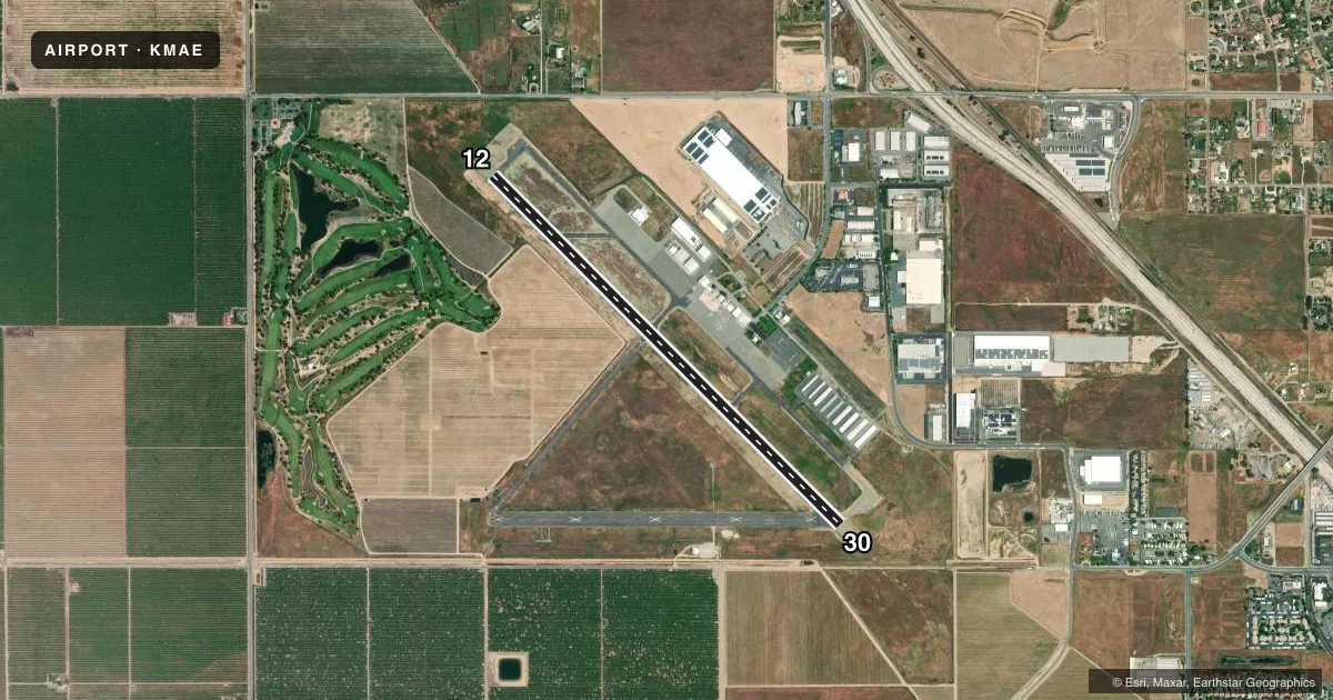
Runways & pattern
Full pagePattern entry · RWY 30
LEFT TRAFFICRunway end performance
| End | TORA | TODA | ASDA | LDA | VGSI | Approach lights | Obstruction |
|---|---|---|---|---|---|---|---|
| 12 | — | — | — | — | PAPI 2-box left(3°) | — | — |
| 30 | — | — | — | — | PAPI 2-box left(3°) | MALSF | — |
Declared distances in feet. TORA = takeoff run available, TODA = takeoff distance, ASDA = accelerate-stop, LDA = landing distance.
Airport sketch
Runways drawn to scale from FAA survey coordinates, rendered over satellite imagery. Not for navigation.
Approaches & charts
Services on the field
Fuel grades, oxygen, maintenance, ramp storage and lighting — as declared to the FAA by the airport operator.
Fuel & services
- Fuel
- 100LLA
- Oxygen (bottled)
- HIGH/LOW
- Oxygen (bulk)
- Not available
- Airframe repair
- Major
- Power plant repair
- Major
- Other services
- AGRI,AVNCS,INSTR,PAJA,SALES
Ramp & ground
- Transient storage
- Tie-down
- Landing fee
- No fee published
- Customs
- Not available
- Lighting schedule
- SEE RMK
- Beacon schedule
- SS-SR
- Beacon
- White / Green (civil land)(WG)
- Wind indicator
- Lighted
- Segmented circle
- Yes
Fuel & FBOs
Cheapest 100LL and Jet A on the field and nearby. Always confirm with the FBO before taxi.
Airport notes
Surface conditions, obstructions, local procedures, lighting outages and other notes published with each FAA cycle.
General notes
- PARACHUTE JUMPING ON ARPT.
- FOR CD CTC FRESNO APCH AT 559-454-9805.
Lighting notes
- ACTVT MIRL RY 12/30; PAPI RYS 12 & 30, REIL RY 12, MALSF RY 30 AND WIND TEE - CTAF.
- ULTRALIGHT ACTIVITY ON AND IN VICINITY OF ARPT; ULTRALIGHT FLY PATTERN 500' AGL NE OF RWY 12/30.
Fuel notes
- 100LLFUEL AVBL 24 HRS WITH AUTOMATED CREDIT CARD.
- AJET A SINGLE POINT PRESSURE REFUELING AVBL VIA TRUCK.
Runway surface & condition
- 12/30OVERRUN 200 FT X 150 FT ASPH RY 12. OVERRUN 200 FT X 150 FT ASPH RY 30.
Approach & departure obstructions
- 30RUBBER BUILD-UP OBSCS CNTRLN MRKG.
VFR map & nearby airports
VFR sectional. Tap any ICAO chip to open that airport.
Key facts · KMAE
Answer card- ICAO
- KMAE
- Name
- MADERA MUNI
- Location
- MADERA, CALIFORNIA
- Elevation
- 255.2 ft MSL
- Traffic pattern altitude
- 1,255.2 ft MSL (1,000 AGL)
- Control tower
- Non-towered (use CTAF)
- Total runways
- 1
- Longest runway
- 12/30 · 5,545 ft
- Published ILS approaches
- 0
- Published frequencies
- 4
- Magnetic variation
- 13°
- Current flight rules
- VFR
- Current wind
- 310° at 4 kt
- Favored runway now
- RWY 30
Madera Muni sits in Madera, California. Field elevation is 255.2 ft MSL. The airport has one runway. Runway 12/30 is 5,545 ft long, which is the longest runway on the field. There is no control tower. Clearance delivery is handled through Fresno Approach. The published frequencies include CTAF and UNICOM on 122.8. Fresno Approach and departure are on 119.45.
No ILS approaches are published here. Pattern altitude is not published in the facts, so use the standard 1,000 ft AGL for light piston traffic unless the current FAA Chart Supplement says otherwise. On-field fuel is available from C&T Aviation and Madera Jet Center. Both carry 100LL, Jet A and Jet A Prist. 100LL is available 24 hours with automated credit card. Jet A is available by truck with single point pressure refueling.
The runway has medium intensity lights. PAPI is installed on both ends. REIL is installed on runway 12. Runway 30 has a medium intensity approach lighting system with sequenced flashing lights. Be aware of the published runway 30 centerline rubber buildup. Ultralight activity occurs on and near the airport. The ultralight pattern is 500 ft AGL northeast of runway 12/30. Parachute jumping also occurs on the airport. Check the current FAA Chart Supplement and call ahead if you want the latest local operating picture.