METAR & TAF KMPI
KMPI does not publish a METAR.
Showing the nearest reporting station: KMCE (MERCED YOSEMITE RGNL) · 26.4 NM away. Conditions at KMPI may differ.
METAR · KMCE
Observed 04:53Z
KMCE 270453Z AUTO 34009KT 10SM CLR 26/11 A2993 RMK AO2 SLP134 T02560111
- Wind
- 340° @ 9 kt
- Visibility
- 10 SM
- Temp / Dew
- 26°C / 11°C
- Altimeter
- 29.93 inHg
- Clouds
- CLR
- Density alt
- 4,103 ft
- Ceiling
- Unlimited
- Rules
- VFR
Airport info & contacts
Manager on record, flight service, ARTCC, attendance schedule and pattern altitude — published by the FAA and refreshed every 28 days.
Location
- From city
- 4 NM W
- VFR sectional
- SAN FRANCISCO
- ARTCC
- ZOA · OAKLAND
- NOTAM facility
- RIU (NOTAM-D)
Airport manager
- Name
- SAMUEL CERVENY
- Phone
- 209-966-5356
- Address
- 4639 BEN HUR ROAD, MARIPOSA CA 95338
Flight service · Hours
- FSS RIU
- RANCHO MURIETA1-800-WX-BRIEF
- Attendance
- MON-FRI · 1000-1600
Frequencies
Tap any row to copy the frequency to your clipboard.
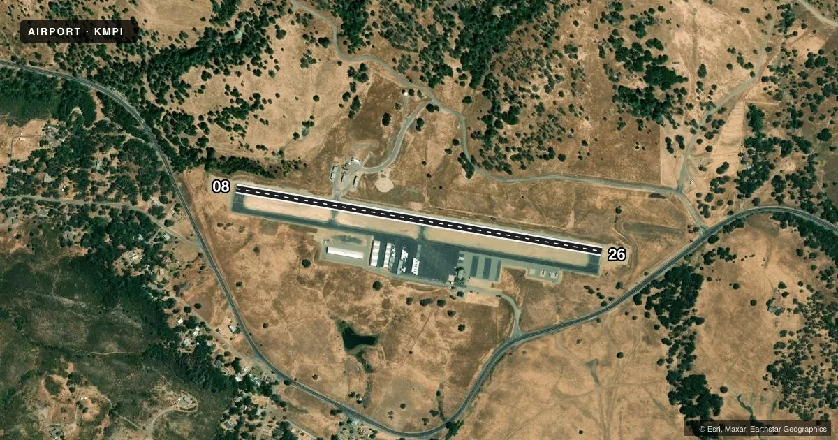
Runways & pattern
Full pagePattern entry · RWY 26
LEFT TRAFFICRunway end performance
| End | TORA | TODA | ASDA | LDA | VGSI | Approach lights | Obstruction |
|---|---|---|---|---|---|---|---|
| 08 | — | — | — | — | PAPI 2-box left(4°) | — | 45', tree, 1340' from thr, 130' R of cntrln, slope 25 |
| 26 | — | — | — | — | PAPI 2-box left(4.5°) | — | 29', tree, 762' from thr, 83' R of cntrln, slope 20 |
Declared distances in feet. TORA = takeoff run available, TODA = takeoff distance, ASDA = accelerate-stop, LDA = landing distance.
Airport sketch
Runways drawn to scale from FAA survey coordinates, rendered over satellite imagery. Not for navigation.
Approaches & charts
Services on the field
Fuel grades, oxygen, maintenance, ramp storage and lighting — as declared to the FAA by the airport operator.
Fuel & services
- Fuel
- 100LLA
- Oxygen (bottled)
- Not available
- Oxygen (bulk)
- Not available
- Airframe repair
- Minor
- Power plant repair
- Minor
- Other services
- INSTR,PAJA,RNTL,SALES
Ramp & ground
- Transient storage
- Tie-down
- Landing fee
- No fee published
- Customs
- Not available
- Lighting schedule
- SEE RMK
- Beacon schedule
- SS-SR
- Beacon
- White / Green (civil land)(WG)
- Wind indicator
- Lighted
- Segmented circle
- Yes
Fuel & FBOs
Cheapest 100LL and Jet A on the field and nearby. Always confirm with the FBO before taxi.
Airport notes
Surface conditions, obstructions, local procedures, lighting outages and other notes published with each FAA cycle.
General notes
- TRANSITIONAL SURFACE OBSTRUCTION: MOUNTAINS TO NORTH OF RWY 08/26.
- RY 08 TERRAIN DROPS ALONG BOTH SIDES OF TWY 45 FT FM RY EDGE.
- BIRDS ON AND INVOF ARPT.
- FOR CD CTC OAKLAND ARTCC AT 510-745-3380.
Lighting notes
- ACTVT PAPI RWY 08 & 26; MIRL RWY 08/26 - CTAF.
Fuel notes
- 100LLFUEL AVBL 24 HRS WITH CREDIT CARD.
Other notes
- 08/26UNSEALED MED TO HIGH SVRTY LONGL AND LATERAL CRACKS IN THE ASPH PAVEMENT EXTD THE ENTIRE LEN OF RWY 8/26 WITH SOME LOOSE DEBRIS FOUND SCATTERED ACRS THE SFC.
VFR map & nearby airports
VFR sectional. Tap any ICAO chip to open that airport.
Key facts · KMPI
Answer card- ICAO
- KMPI
- Name
- MARIPOSA-YOSEMITE
- Location
- MARIPOSA, CALIFORNIA
- Elevation
- 2,254.2 ft MSL
- Traffic pattern altitude
- 3,254.2 ft MSL (1,000 AGL)
- Control tower
- Non-towered (use CTAF)
- Total runways
- 1
- Longest runway
- 08/26 · 3,305 ft
- Published ILS approaches
- 0
- Published frequencies
- 2
- Magnetic variation
- 15°
- Current flight rules
- VFR
- Current wind
- 340° at 9 kt
- Favored runway now
- RWY 26
Mariposa-Yosemite Airport sits in Mariposa, California at 2,254.2 ft MSL. It has one runway, 08/26, which is 3,305 ft long. The field is non-towered. CTAF and UNICOM are both 122.7. No ILS approaches are published here. Pattern altitude is not published, so use the standard 1,000 ft AGL for light piston traffic unless the current Chart Supplement says otherwise.
The on-field FBO is Mariposa-Yosemite Airport. It carries 100LL and Jet A. Fuel is available 24 hours with credit card. That is useful here because the airport sits in mountain country. Published remarks also note mountains north of runway 08/26. Runway 08 has terrain dropping away on both sides of the taxiway. Birds are present on and near the airport. The runway also has medium intensity lights and a PAPI for both ends. Clearance delivery is handled through Oakland Center. Expect to verify the current procedure before departure.
For a first-time arrival, the big items are terrain, runway condition and density altitude. The pavement has reported cracks and loose debris along the full length of 08/26. Check the current Chart Supplement and the airport operator before you go. A mountain airport at this elevation can change performance fast.