METAR & TAF O27
O27 does not publish a METAR.
Showing the nearest reporting station: KMOD (MODESTO CITY-COUNTY-HARRY SHAM FLD) · 10.7 NM away. Conditions at O27 may differ.
METAR · KMOD
Observed 09:53Z
KMOD 270953Z AUTO 34006KT 10SM CLR 19/08 A2993 RMK AO2 SLP133 T01940078 $
- Wind
- 340° @ 6 kt
- Visibility
- 10 SM
- Temp / Dew
- 19°C / 8°C
- Altimeter
- 29.93 inHg
- Clouds
- CLR
- Density alt
- 761 ft
- Ceiling
- Unlimited
- Rules
- VFR
Airport info & contacts
Manager on record, flight service, ARTCC, attendance schedule and pattern altitude — published by the FAA and refreshed every 28 days.
Location
- From city
- 3 NM SE
- VFR sectional
- SAN FRANCISCO
- ARTCC
- ZOA · OAKLAND
- NOTAM facility
- RIU (NOTAM-D)
Airport manager
- Name
- TYLER HENDON
- Phone
- (209) 845-3640
- Address
- 455 SOUTH FIFTH AVENUE, OAKDALE CA 95361
Flight service · Hours
- FSS RIU
- RANCHO MURIETA1-800-WX-BRIEF
- Attendance
- DALGT
Frequencies
Tap any row to copy the frequency to your clipboard.
Runways & pattern
Full pagePattern entry · RWY 28
LEFT TRAFFICRunway end performance
| End | TORA | TODA | ASDA | LDA | VGSI | Approach lights | Obstruction |
|---|---|---|---|---|---|---|---|
| 10 | — | — | — | — | VASI 2-box left(2.5°) | — | — |
| 28 | — | — | — | — | PAPI 2-box left(3°) | — | — |
Declared distances in feet. TORA = takeoff run available, TODA = takeoff distance, ASDA = accelerate-stop, LDA = landing distance.
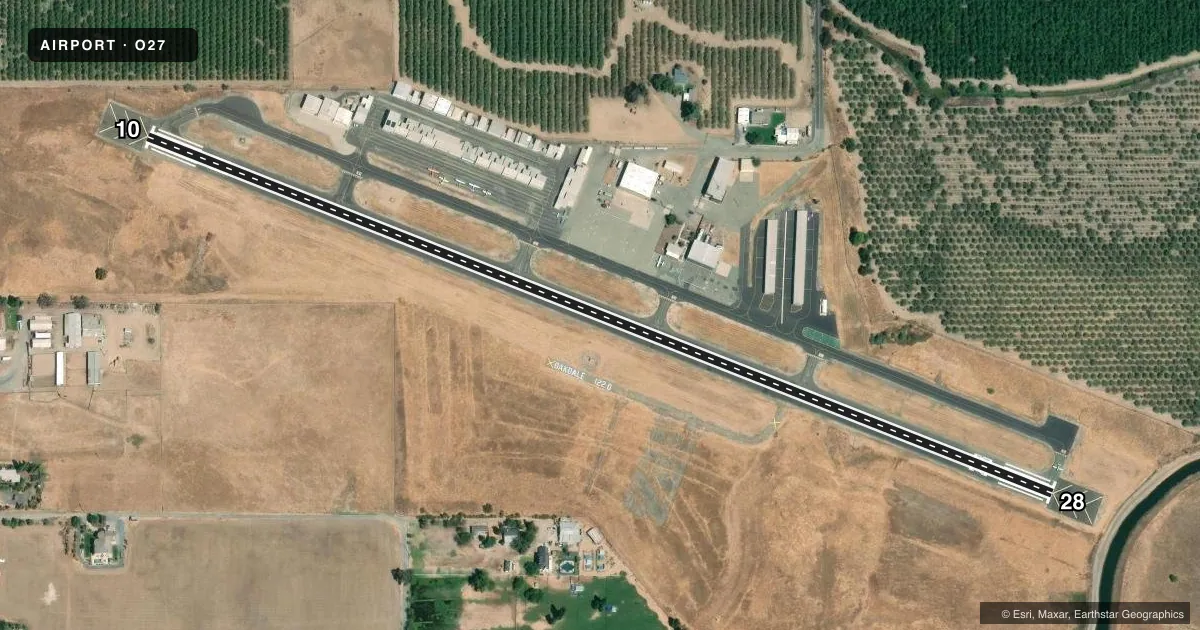
Airport sketch
Runways drawn to scale from FAA survey coordinates, rendered over satellite imagery. Not for navigation.
Approaches & charts
Services on the field
Fuel grades, oxygen, maintenance, ramp storage and lighting — as declared to the FAA by the airport operator.
Fuel & services
- Fuel
- 100LL
- Oxygen (bottled)
- Not available
- Oxygen (bulk)
- Not available
- Airframe repair
- Not available
- Power plant repair
- Not available
- Other services
- RNTL
Ramp & ground
- Transient storage
- Tie-down
- Landing fee
- No fee published
- Customs
- Not available
- Lighting schedule
- SEE RMK
- Beacon schedule
- SS-SR
- Beacon
- White / Green (civil land)(WG)
- Wind indicator
- Lighted
- Segmented circle
- Yes
Fuel & FBOs
Cheapest 100LL and Jet A on the field and nearby. Always confirm with the FBO before taxi.
Airport notes
Surface conditions, obstructions, local procedures, lighting outages and other notes published with each FAA cycle.
General notes
- APRON ON SOUTH SIDE OF RY DAMAGED & UNUSABLE.
- FOR CD CTC NORCAL APCH AT 916-361-0516.
- RWY 28 APCH RWY SAFETY AREA BISECTED BY AN IRRIGATION CANAL 230 FT FROM THE RWY END.
Lighting notes
- ACTVT MIRL RWY 10/28 - CTAF. REIL RWY 10 & 28; VASI RWY 10; PAPI RWY 28 OPR CONSLY.
Other notes
- PREDATES THE FAA ACT.
- 1NIGHTS ON CALL 1-800-868-8750.
VFR map & nearby airports
VFR sectional. Tap any ICAO chip to open that airport.
Key facts · O27
Answer card- ICAO
- O27
- Name
- OAKDALE
- Location
- OAKDALE, CALIFORNIA
- Elevation
- 236.5 ft MSL
- Traffic pattern altitude
- 1,236.5 ft MSL (1,000 AGL)
- Control tower
- Non-towered (use CTAF)
- Total runways
- 1
- Longest runway
- 10/28 · 3,013 ft
- Published ILS approaches
- 0
- Published frequencies
- 4
- Magnetic variation
- 15°
- Current flight rules
- VFR
- Current wind
- 340° at 6 kt
- Favored runway now
- RWY 28
Oakdale Airport sits in Oakdale, California at 236.5 ft MSL. It has one runway. Runway 10/28 is 3,013 ft long on asphalt, so this is a short-field airport by jet standards and a normal fit for light piston traffic. There is no control tower. NorCal provides approach and departure service on 125.1 and 363.2. CTAF and UNICOM are both 122.8. No ILS approaches are published here, so plan for visual work or non-ILS procedures as appropriate.
The published pattern altitude is not listed, so use the standard 1,000 ft AGL for light piston aircraft unless the current Chart Supplement says otherwise. The field carries 15° magnetic variation. Oakdale Municipal Airport is the on-field FBO. It carries 100LL. Call (209) 845-3640 for current service details before you go.
A few remarks matter here. The airport predates the FAA Act. Night operations are on call at 1-800-868-8750. The runway 28 safety area is cut by an irrigation canal 230 ft from the runway end. The south apron is damaged and unusable. Runway lights on 10/28 are radio-activated on CTAF. Runway end identifier lights are on both ends. VASI is on runway 10. PAPI is on runway 28 and runs continuously. For clearance delivery, contact NorCal Approach at 916-361-0516.