METAR & TAF KMOD
Current METAR
Observed 10:53Z
KMOD 271053Z AUTO 35007KT 10SM CLR 19/08 A2993 RMK AO2 SLP134 T01890083 $
- Wind
- 350° @ 7 kt
- Visibility
- 10 SM
- Temp / Dew
- 19°C / 8°C
- Altimeter
- 29.93 inHg
- Clouds
- CLR
- Density alt
- 591 ft
- Ceiling
- Unlimited
- Rules
- VFR
Airport info & contacts
Manager on record, flight service, ARTCC, attendance schedule and pattern altitude — published by the FAA and refreshed every 28 days.
Location
- From city
- 2 NM SE
- VFR sectional
- SAN FRANCISCO
- ARTCC
- ZOA · OAKLAND
- NOTAM facility
- MOD (NOTAM-D)
Airport manager
- Name
- MARISOL NAVARRO
- Phone
- 209-577-5318
- Address
- 617 AIRPORT WAY, MODESTO CA 95354-3916
Flight service · Hours
- FSS RIU
- RANCHO MURIETA1-800-WX-BRIEF
- Attendance
- MON-FRI · 0800 -1630
Frequencies
Tap any row to copy the frequency to your clipboard.
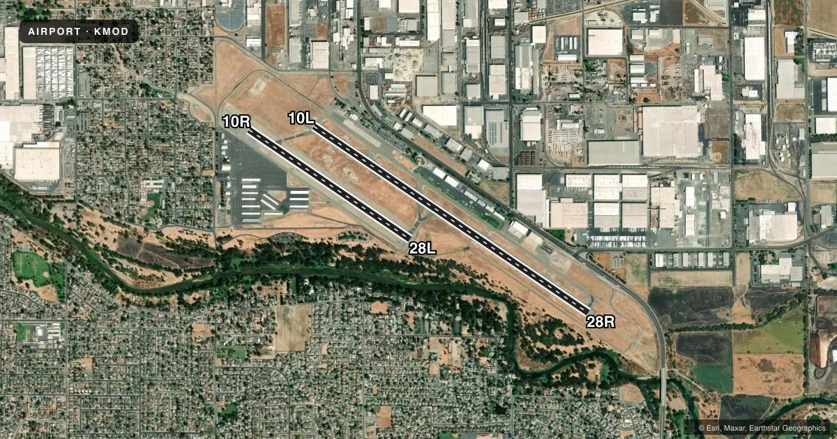
Runways & pattern
Full pagePattern entry · RWY 28R
RIGHT TRAFFIC| Runway | Heading (°M) | Length | Surface | Traffic |
|---|---|---|---|---|
| 10L/28RFavored | 108° / 288° | 5,904 ft | ASPH | 28R R |
| 10R/28L | 108° / 288° | 3,464 ft | ASPH | 10R R |
Runway end performance
| End | TORA | TODA | ASDA | LDA | VGSI | Approach lights | Obstruction |
|---|---|---|---|---|---|---|---|
| 10L | 5,904' | 5,904' | 5,904' | 5,904' | PAPI 4-box right(3°) | — | 73', tree, 2700' from thr, 450' R of cntrln, slope 34 |
| 28R | 5,904' | 5,904' | 5,904' | 5,904' | — | MALSR | 14', road, 1600' from thr, 0' R of cntrln, slope 50 |
| 10R | 3,464' | 3,464' | 3,464' | 3,464' | PAPI 2-box left(3.5°) | — | 56', tree, 1340' from thr, 75' R of cntrln, slope 20 |
| 28L | 3,464' | 3,464' | 3,464' | 3,464' | PAPI 2-box left(3°) | — | 47', tree, 1700' from thr, 50' R of cntrln, slope 31 |
Declared distances in feet. TORA = takeoff run available, TODA = takeoff distance, ASDA = accelerate-stop, LDA = landing distance.
Airport sketch
Runways drawn to scale from FAA survey coordinates, rendered over satellite imagery. Not for navigation.
Approaches & charts
ILS · 1
Services on the field
Fuel grades, oxygen, maintenance, ramp storage and lighting — as declared to the FAA by the airport operator.
Fuel & services
- Fuel
- 100LLAA1+
- Oxygen (bottled)
- Not available
- Oxygen (bulk)
- HIGH/LOW
- Airframe repair
- Major
- Power plant repair
- Major
- Other services
- AFRT,AMB,AVNCS,CARGO,CHTR,INSTR,RNTL,SALES
Ramp & ground
- Transient storage
- Tie-down
- Hangar
- Landing fee
- Yes
- Customs
- Not available
- Lighting schedule
- SEE RMK
- Beacon schedule
- SS-SR
- Beacon
- White / Green (civil land)(WG)
- Wind indicator
- Lighted
- Segmented circle
- Yes
Fuel & FBOs
Cheapest 100LL and Jet A on the field and nearby. Always confirm with the FBO before taxi.
Airport notes
Surface conditions, obstructions, local procedures, lighting outages and other notes published with each FAA cycle.
General notes
- IN THE INTEREST OF NOISE ABATEMENT: TUBO JETS DISCONTINUE OPNS 2400-0500 LCL & PARK ON NE RAMP.
- ALL PURE JET AND LARGE ACFT LMTD TO PRKG AND SVC AT NE RAMP ONLY.
- AVIATION WX AVBL WHEN ATCT OPNL CALL 209-526-4555.
- NOISE ABATEMENT PROCEDURES: PILOTS ARE REQUESTED TO USE LGTD RWY ONLY.
- RWY 10R/28L NOT CERTIFICATED FOR FAR-139.
- PONDING ALONG NORTH EDGE OF TWY B DURING AND AFTER WET WEATHER.
- FOR CD WHEN ATCT CLSD CTC NORCAL APCH AT 916-361-0516.
- BIRDS AND SMALL MAMMALS ON AND IN VICINITY OF AP.
Lighting notes
- WHEN ATCT CLSD ACTVT MALSR RWY 28R; REIL RWY 10L; PAPI RWY 10L; HIRL RWY 10L/28R - CTAF. PAPI RWYS 10R & 28L AND MIRL RWY 10R/28L UNAVBL WHEN ATCT CLSD.
Runway surface & condition
- 10R/28L<RWY 10R-28L CLSD TO ACFT OVER 12500 LBS GWT
Approach & departure obstructions
- 10LUNUSBL BYD 8 DEGS LEFT OF RWY CNTRLN.
Other notes
- PPR 72 HRS FOR ACR OPNS WITH MORE THAN 30 PSGR SEATS 0800-1700 WKDAYS CALL AMGR (209) 577-5318.
- FEE FOR ACFT OVER 9501 LBS, OVNGT TIEDOWN FEE.
VFR map & nearby airports
VFR sectional. Tap any ICAO chip to open that airport.
Key facts · KMOD
Answer card- ICAO
- KMOD
- Name
- MODESTO CITY-COUNTY-HARRY SHAM FLD
- Location
- MODESTO, CALIFORNIA
- Elevation
- 99.2 ft MSL
- Traffic pattern altitude
- 1,099.2 ft MSL (1,000 AGL)
- Control tower
- Towered · 0700-2100
- Total runways
- 2
- Longest runway
- 10L/28R · 5,904 ft
- Published ILS approaches
- 1
- Published frequencies
- 14
- Magnetic variation
- 16°
- Current flight rules
- VFR
- Current wind
- 350° at 7 kt
- Favored runway now
- RWY 28R
Modesto City-County-Harry Sham FLD (KMOD) sits in Modesto, California. Field elevation is 99.2 ft MSL. The airport has two asphalt runways. The longest is 10L/28R at 5,904 ft. The other runway is 10R/28L at 3,464 ft. The tower is open 0700-2100. There is 1 ILS approach. It serves runway 28R.
Pattern altitude is not published in the facts. Use the standard 1,000 ft AGL for light piston traffic unless ATC or the current Chart Supplement says otherwise. Modesto Jet Center is on the field. It carries 100LL, Jet A and Jet A Prist. Noise abatement asks pilots to use lighted runways only. That matters here because the field also has published lighting notes for tower-closed operations. When the tower is closed, some lighting on 10R/28L is unavailable. Plan ahead if you expect a night arrival.
This is a controlled airport with NorCal approach and departure on 120.95. The airport also has published notes for birds and small mammals in the area. Taxiway B can hold water along its north edge during and after wet weather. Large aircraft and pure jets have parking limits on the northeast ramp. Check the current Chart Supplement for any current restrictions before you go.