METAR & TAF KMCE
Current METAR
Observed 05:53Z
KMCE 270553Z AUTO 35011KT 10SM CLR 24/12 A2994 RMK AO2 SLP136 T02390117 10356 20239 51016
- Wind
- 350° @ 11 kt
- Visibility
- 10 SM
- Temp / Dew
- 24°C / 12°C
- Altimeter
- 29.94 inHg
- Clouds
- CLR
- Density alt
- 1,248 ft
- Ceiling
- Unlimited
- Rules
- VFR
Airport info & contacts
Manager on record, flight service, ARTCC, attendance schedule and pattern altitude — published by the FAA and refreshed every 28 days.
Location
- From city
- 2 NM SW
- VFR sectional
- SAN FRANCISCO
- ARTCC
- ZOA · OAKLAND
- NOTAM facility
- MCE (NOTAM-D)
Airport manager
- Name
- RHETT WILLIAMS
- Phone
- 209-385-6873
- Address
- 20 MACREADY DR., MERCED CA 95341
Flight service · Hours
- FSS RIU
- RANCHO MURIETA1-800-WX-BRIEF
- Attendance
- 0600-1800
Frequencies
Tap any row to copy the frequency to your clipboard.
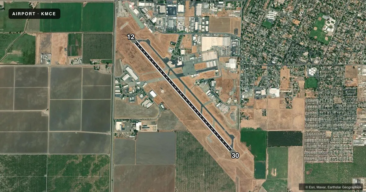
Runways & pattern
Full pagePattern entry · RWY 30
LEFT TRAFFICRunway end performance
| End | TORA | TODA | ASDA | LDA | VGSI | Approach lights | Obstruction |
|---|---|---|---|---|---|---|---|
| 12 | — | — | — | — | VASI 4-box left(3°) | — | 20', pole, 800' from thr, 225' R of cntrln, slope 30 |
| 30 | — | — | — | — | PAPI 4-box left(3°) | MALSR | 42', pline, 1800' from thr, 650' R of cntrln, slope 38 |
Declared distances in feet. TORA = takeoff run available, TODA = takeoff distance, ASDA = accelerate-stop, LDA = landing distance.
Airport sketch
Runways drawn to scale from FAA survey coordinates, rendered over satellite imagery. Not for navigation.
Approaches & charts
ILS · 1
Services on the field
Fuel grades, oxygen, maintenance, ramp storage and lighting — as declared to the FAA by the airport operator.
Fuel & services
- Fuel
- 100LLA
- Oxygen (bottled)
- Not available
- Oxygen (bulk)
- Not available
- Airframe repair
- Major
- Power plant repair
- Major
- Other services
- AFRT,CHTR,INSTR,RNTL,SALES
Ramp & ground
- Transient storage
- Tie-down
- Landing fee
- No fee published
- Customs
- Not available
- Lighting schedule
- SEE RMK
- Beacon schedule
- SS-SR
- Beacon
- White / Green (civil land)(WG)
- Wind indicator
- Lighted
- Segmented circle
- Yes
Fuel & FBOs
Cheapest 100LL and Jet A on the field and nearby. Always confirm with the FBO before taxi.
Airport notes
Surface conditions, obstructions, local procedures, lighting outages and other notes published with each FAA cycle.
General notes
- NOISE ABATEMENT PROCEDURES IN EFFECT, RECOMMEND ACFT REMAIN EAST/WEST OF CITY OF MERCED AT ALT ABOVE 1,500 FT MSL. DEPARTING TFC RWY 12 NO LEFT TURNS OVER CITY UNTIL REACHING 3,000 FT MSL.
- PPR 24 HRS FOR UNSKED ACFT OPNS WITH MORE THAN 30 PSGR SEATS CALL AMGR 209-564-0120.
- RY 30 PREFERRED WIND RUNWAY.
- BE ALERT FOR EXTENSIVE STUDENT TRAINING WITHIN 10 NMR OF AIRPORT. TWO-WAY RADIO COMMUNICATION RECOMMENDED.
- INCRD SEAGULL ACT ON RWY IN PUDDLES.
- FOR CD CTC NORCAL APCH AT 916-361-0516.
Lighting notes
- ACTVT MALSR RWY 30; REIL RWY 12; PAPI RWY 30; HIRL RWY 12/30 - CTAF; KEY 7 CLICKS HIGH, 5 CLICKS MED, 3 CLICKS LOW. VASI RWY 12 OPER CONSLY.
Fuel notes
- 100LLFOR FUEL AFT HRS CALL (209) 722-6300. SELF SERVICE 100LL AVBL 24/7.
Other notes
- THIS AIRPORT HAS BEEN SURVEYED BY THE NATIONAL GEODETIC SURVEY.
- ARFF INDEX B 24 HOURS PPR
- SUPPLEMENTAL WIND SOCK FOR RWY 30 NOT AVBL.
- MANAGEREMAIL: WILLIAMSR@CITYOFMERCED.ORG
- MANAGEROR 209-564-0120
- OWNER24 HOURS
VFR map & nearby airports
VFR sectional. Tap any ICAO chip to open that airport.
Key facts · KMCE
Answer card- ICAO
- KMCE
- Name
- MERCED YOSEMITE RGNL
- Location
- MERCED, CALIFORNIA
- Elevation
- 155.2 ft MSL
- Traffic pattern altitude
- 1,155.2 ft MSL (1,000 AGL)
- Control tower
- Non-towered (use CTAF)
- Total runways
- 1
- Longest runway
- 12/30 · 5,914 ft
- Published ILS approaches
- 1
- Published frequencies
- 4
- Magnetic variation
- 15°
- Current flight rules
- VFR
- Current wind
- 350° at 11 kt
- Favored runway now
- RWY 30
MERCED YOSEMITE RGNL sits in Merced, California. The field elevation is 155.2 ft MSL. It has one runway. Runway 12/30 is 5,914 ft of asphalt. Runway 30 is the preferred wind runway. There is no control tower. Expect CTAF and UNICOM use on 122.7.
The airport has one ILS approach to runway 30. Pattern altitude is not published. For light piston traffic, use the standard 1,000 ft AGL unless the current Chart Supplement or ATC gives you something different. The field is in NORCAL airspace with approach and departure service on 120.95 and 269.45.
Gateway Air Center is on the field. It carries 100LL, Jet A and Jet A Prist. Self-serve 100LL is available 24 hours a day, 7 days a week. After hours fuel support is listed by phone. Noise abatement is active here. Stay east or west of Merced above 1,500 ft MSL when practical. Departures from runway 12 should not turn left over the city until reaching 3,000 ft MSL. Expect a lot of student training within 10 NM. Two-way radio calls are recommended. Watch for seagulls on the runway, especially in puddles.