METAR & TAF KMER
Current METAR
Observed 02:55Z
KMER 250255Z 33015KT 10SM CLR
- Wind
- 330° @ 15 kt
- Visibility
- 10 SM
- Temp / Dew
- —
- Altimeter
- —
- Clouds
- CLR
- Density alt
- —
- Ceiling
- Unlimited
- Rules
- VFR
Airport info & contacts
Manager on record, flight service, ARTCC, attendance schedule and pattern altitude — published by the FAA and refreshed every 28 days.
Location
- From city
- 3 NM NE
- VFR sectional
- SAN FRANCISCO
- ARTCC
- ZOA · OAKLAND
- NOTAM facility
- MER (NOTAM-D)
Airport manager
- Name
- GEORGE CLOVER
- Phone
- 209-617-5399
- Address
- 2222 M STREET, MERCED CA 95340-4180
Flight service · Hours
- FSS RIU
- RANCHO MURIETA1-800-WX-BRIEF
- Attendance
- MON-FRI · 0800-1700
Frequencies
Tap any row to copy the frequency to your clipboard.
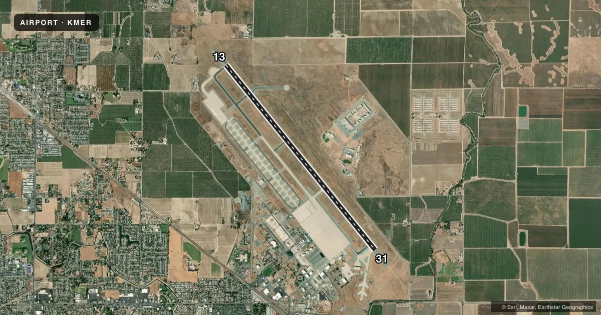
Runways & pattern
Full pagePattern entry · RWY 31
RIGHT TRAFFICRunway end performance
| End | TORA | TODA | ASDA | LDA | VGSI | Approach lights | Obstruction |
|---|---|---|---|---|---|---|---|
| 13 | — | — | — | — | PAPI 4-box left(3°) | ALSF1 | — |
| 31 | — | — | — | — | PAPI 4-box left(3°) | ALSF1 | — |
Declared distances in feet. TORA = takeoff run available, TODA = takeoff distance, ASDA = accelerate-stop, LDA = landing distance.
Airport sketch
Runways drawn to scale from FAA survey coordinates, rendered over satellite imagery. Not for navigation.
Approaches & charts
ILS · 1
Services on the field
Fuel grades, oxygen, maintenance, ramp storage and lighting — as declared to the FAA by the airport operator.
Fuel & services
- Fuel
- 100LLAA1
- Airframe repair
- Minor
- Power plant repair
- Minor
Ramp & ground
- Transient storage
- Tie-down
- Hangar
- Landing fee
- No fee published
- Customs
- Not available
- Lighting schedule
- SEE RMK
- Beacon schedule
- SS-SR
- Beacon
- White / Green (civil land)(WG)
- Wind indicator
- Lighted
- Segmented circle
- Yes
Fuel & FBOs
Cheapest 100LL and Jet A on the field and nearby. Always confirm with the FBO before taxi.
Airport notes
Surface conditions, obstructions, local procedures, lighting outages and other notes published with each FAA cycle.
General notes
- RY 13/31 180 DEGREE TURNS PROHIBITIED.
- FOR ARPT INFO 209-385-7686, EXTN 4180.
- RY 31 WILL BE THE DESIGNATED CALM WIND RY (WIND 5 KNOTS OR LESS).
- OPPOSITE END OF RY NOT VISIBLE ON TKOF. WHEN ATCT CLSD OPPOSITE DIRECTION TAKEOFFS AND LANDINGS ARE NOT AUTHORIZED.
- CIVILIAN AND MILITARY TRAINING MAY OCCASIONALLY CAUSE PATTERN CONGESTION.
- WHEN ATCT CLSD MAX OF 5 ACFT PMTD IN VFR TFC PAT AT ANY ONE TIME AND 2000 FT CIG AND 3 MIS VIS RCMDD.
- FOR CD WHEN ATCT IS CLSD CTC NORCAL APCH AT 916-361-0516.
- TWY B CLSD TO ACFT GTR THAN 30000 LBS.
Lighting notes
- WHEN ATCT CLSD ACTVT ALSF1 RWYS 13 & 31; HIRL RWY 13/31 - CTAF; 3 CLICKS ON, 5 CLICKS INCR INTST, 7 CLICKS OFF. PAPI RWYS 13 & 31 OPR CONSLY.
Fuel notes
- 100LLFOR FUEL FM 1800-0900 CALL (209) 725-1455.
Runway surface & condition
- 13/311,000 FT PAVED BLAST PAD BOTH ENDS OF RY.
Approach & departure obstructions
- 31ALSF1 RY 13/31 SEQUENCED FLASHING LGTS OTS INDEFLY.
Other notes
- NO OBJECTIONS
- MANAGERMAILING ADDRESS
- OWNERCOMMUNITY & ECONOMIC DEVELOPMENT
- MANAGERDESK PHONE 209-385-7686, EXTN 4180.
VFR map & nearby airports
VFR sectional. Tap any ICAO chip to open that airport.
Key facts · KMER
Answer card- ICAO
- KMER
- Name
- CASTLE
- Location
- ATWATER, CALIFORNIA
- Elevation
- 190.4 ft MSL
- Traffic pattern altitude
- 1,190.4 ft MSL (1,000 AGL)
- Control tower
- Towered · 0700-2100
- Total runways
- 1
- Longest runway
- 13/31 · 11,802 ft
- Published ILS approaches
- 1
- Published frequencies
- 8
- Magnetic variation
- 15°
- Current flight rules
- VFR
- Current wind
- 330° at 15 kt
- Favored runway now
- RWY 31
Castle Airport sits in Atwater, California. Field elevation is 190.4 ft MSL. The airport has one runway, 13/31, which is 11,802 ft long with asphalt-concrete pavement. The tower is open 0700-2100. When the tower is closed, use CTAF for lighting activation and clearance delivery goes through NorCal Approach. The field has one ILS approach to runway 31. Pattern altitude is not published, so use the standard 1,000 ft AGL for light piston operations unless current instructions say otherwise.
KT Aero is on the field. It carries 100LL, Jet A and Jet A Prist. For fuel from 1800 to 0900, call the number in the Chart Supplement or contact the FBO directly. The published remarks also note a 1,000 ft paved blast pad at both ends of runway 13/31. Opposite direction takeoffs and landings are not authorized when the tower is closed. The opposite end of the runway is not visible on takeoff. Civilian and military training can add pattern congestion.
This is a long runway at a low-elevation field. Performance is usually straightforward. The main things to brief are tower hours, the runway 31 ILS and the closed-tower lighting procedures. Taxiway B is closed to aircraft over 30,000 lb. Check current procedures before you go.