METAR & TAF KLSN
KLSN does not publish a METAR.
Showing the nearest reporting station: KMCE (MERCED YOSEMITE RGNL) · 21.6 NM away. Conditions at KLSN may differ.
METAR · KMCE
Observed 10:53Z
KMCE 271053Z AUTO 30005KT 10SM CLR 19/08 A2993 RMK AO2 SLP131 T01940078
- Wind
- 300° @ 5 kt
- Visibility
- 10 SM
- Temp / Dew
- 19°C / 8°C
- Altimeter
- 29.93 inHg
- Clouds
- CLR
- Density alt
- 618 ft
- Ceiling
- Unlimited
- Rules
- VFR
Airport info & contacts
Manager on record, flight service, ARTCC, attendance schedule and pattern altitude — published by the FAA and refreshed every 28 days.
Location
- From city
- 1 NM W
- VFR sectional
- SAN FRANCISCO
- Pattern altitude
- 800 ft AGL · 921 ft MSL
- ARTCC
- ZOA · OAKLAND
- NOTAM facility
- RIU (NOTAM-D)
Airport manager
- Name
- MARC HEGUY
- Phone
- (209) 827-7056
- Address
- 411 MADISON AVENUE, LOS BANOS CA 93635-4214
Flight service · Hours
- FSS RIU
- RANCHO MURIETA1-800-WX-BRIEF
- Attendance
- Unattended
Frequencies
Tap any row to copy the frequency to your clipboard.
Runways & pattern
Full pagePattern entry · RWY 32
LEFT TRAFFICRunway end performance
| End | TORA | TODA | ASDA | LDA | VGSI | Approach lights | Obstruction |
|---|---|---|---|---|---|---|---|
| 14 | — | — | — | — | PAPI 2-box left(3°) | — | 40', pline, 1500' from thr, 50' R of cntrln, slope 33 |
| 32 | — | — | — | — | PAPI 2-box left(3°) | — | 25', tree, 760' from thr, 25' R of cntrln, slope 21 |
Declared distances in feet. TORA = takeoff run available, TODA = takeoff distance, ASDA = accelerate-stop, LDA = landing distance.
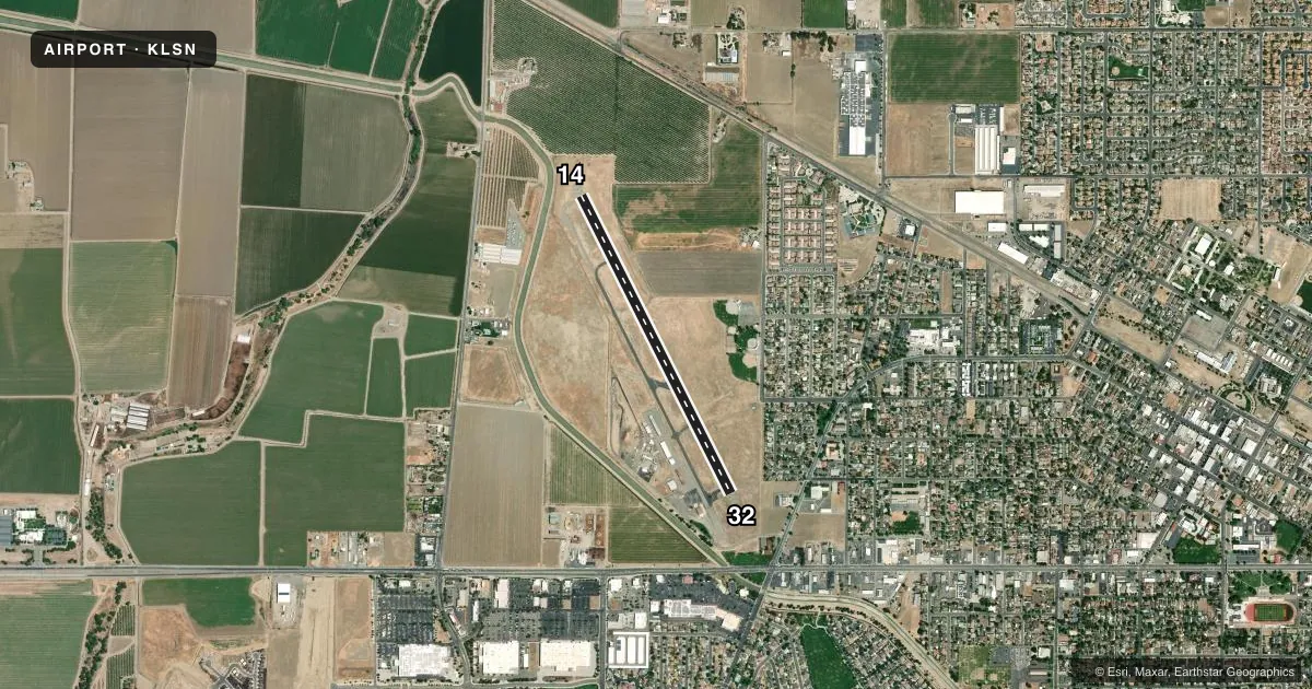
Airport sketch
Runways drawn to scale from FAA survey coordinates, rendered over satellite imagery. Not for navigation.
Approaches & charts
Services on the field
Fuel grades, oxygen, maintenance, ramp storage and lighting — as declared to the FAA by the airport operator.
Fuel & services
- Fuel
- 100LLA
- Oxygen (bottled)
- Not available
- Oxygen (bulk)
- Not available
- Airframe repair
- Minor
- Power plant repair
- Minor
Ramp & ground
- Transient storage
- Tie-down
- Landing fee
- No fee published
- Customs
- Not available
- Lighting schedule
- SEE RMK
- Beacon schedule
- SS-SR
- Beacon
- White / Green (civil land)(WG)
- Wind indicator
- Lighted
- Segmented circle
- Yes
Fuel & FBOs
Cheapest 100LL and Jet A on the field and nearby. Always confirm with the FBO before taxi.
Airport notes
Surface conditions, obstructions, local procedures, lighting outages and other notes published with each FAA cycle.
General notes
- AVOID OVERFLIGHT OF HOUSES SOUTH OF ARPT.
- NO DEPS OVER HOUSING AREAS TO EAST OF ARPT.
- FOR CD CTC NORCAL APCH AT 916-361-0516.
Lighting notes
- MIRL RY 14/32 PRESET LOW INTST UNTIL 2400. TO INCR INTST AND ACTVT MIRL, REIL RY 14, RY 32 AND PAPI RY 14 AND RY 32 - CTAF.
Fuel notes
- 100LL24 HR AUTOMATED FUEL AVBL WITH MAJOR CREDIT CARD. CALL 209-827-7070 AFTER HRS FOR EMERG FULL SRV.
VFR map & nearby airports
VFR sectional. Tap any ICAO chip to open that airport.
Key facts · KLSN
Answer card- ICAO
- KLSN
- Name
- LOS BANOS MUNI
- Location
- LOS BANOS, CALIFORNIA
- Elevation
- 121.4 ft MSL
- Traffic pattern altitude
- 921.4 ft MSL (800 AGL)
- Control tower
- Non-towered (use CTAF)
- Total runways
- 1
- Longest runway
- 14/32 · 3,801 ft
- Published ILS approaches
- 0
- Published frequencies
- 4
- Magnetic variation
- 16°
- Current flight rules
- VFR
- Current wind
- 300° at 5 kt
- Favored runway now
- RWY 32
Los Banos Muni Airport (KLSN) sits in Los Banos, California. Field elevation is 121.4 ft MSL. The airport has one runway, 14/32, which is 3,801 ft long and paved asphalt. There is no control tower. Pattern altitude is 800 ft AGL, which is 921.4 ft MSL.
No ILS approaches are published here. For clearance delivery, contact NorCal Approach at 916-361-0516. The airport uses CTAF 122.8, which is also the UNICOM frequency. The on-field FBO is Los Banos Municipal Airport. It carries 100LL and Jet A. Twenty-four hour automated fuel is available with a major credit card. Call the listed number after hours for emergency full service.
This field has some operational items worth planning for. The runway remarks note widespread cracking and surface wear on 14/32, so expect a rougher surface than a newer strip. Medium intensity runway lights are preset to low intensity until 2400. Use CTAF to increase intensity and to activate the runway end identifier lights and PAPI. Avoid overflight of houses south of the airport. Do not plan departures over housing areas to the east. The field is in the Central Valley, so density altitude can still matter on warm days even at low elevation. Check the current FAA Chart Supplement for any current restrictions before you go.