METAR & TAF O15
O15 does not publish a METAR.
Showing the nearest reporting station: KMER (CASTLE) · 8.7 NM away. Conditions at O15 may differ.
METAR · KMER
Observed 02:55Z
KMER 250255Z 33015KT 10SM CLR
- Wind
- 330° @ 15 kt
- Visibility
- 10 SM
- Temp / Dew
- —
- Altimeter
- —
- Clouds
- CLR
- Density alt
- —
- Ceiling
- Unlimited
- Rules
- VFR
Airport info & contacts
Manager on record, flight service, ARTCC, attendance schedule and pattern altitude — published by the FAA and refreshed every 28 days.
Location
- From city
- 8 NM E
- VFR sectional
- SAN FRANCISCO
- Pattern altitude
- 800 ft AGL · 961 ft MSL
- ARTCC
- ZOA · OAKLAND
- NOTAM facility
- RIU (NOTAM-D)
Airport manager
- Name
- CHRIS FISHER
- Phone
- (209) 668-5599
- Address
- 144 S. BROADWAY, TURLOCK CA 95380
Flight service · Hours
- FSS RIU
- RANCHO MURIETA1-800-WX-BRIEF
- Attendance
- Unattended
Frequencies
Tap any row to copy the frequency to your clipboard.
Runways & pattern
Full pagePattern entry · RWY 30
LEFT TRAFFICRunway end performance
| End | TORA | TODA | ASDA | LDA | VGSI | Approach lights | Obstruction |
|---|---|---|---|---|---|---|---|
| 12 | — | — | — | — | — | — | 30', pole, 800' from thr, 130' R of cntrln, slope 20 |
Declared distances in feet. TORA = takeoff run available, TODA = takeoff distance, ASDA = accelerate-stop, LDA = landing distance.
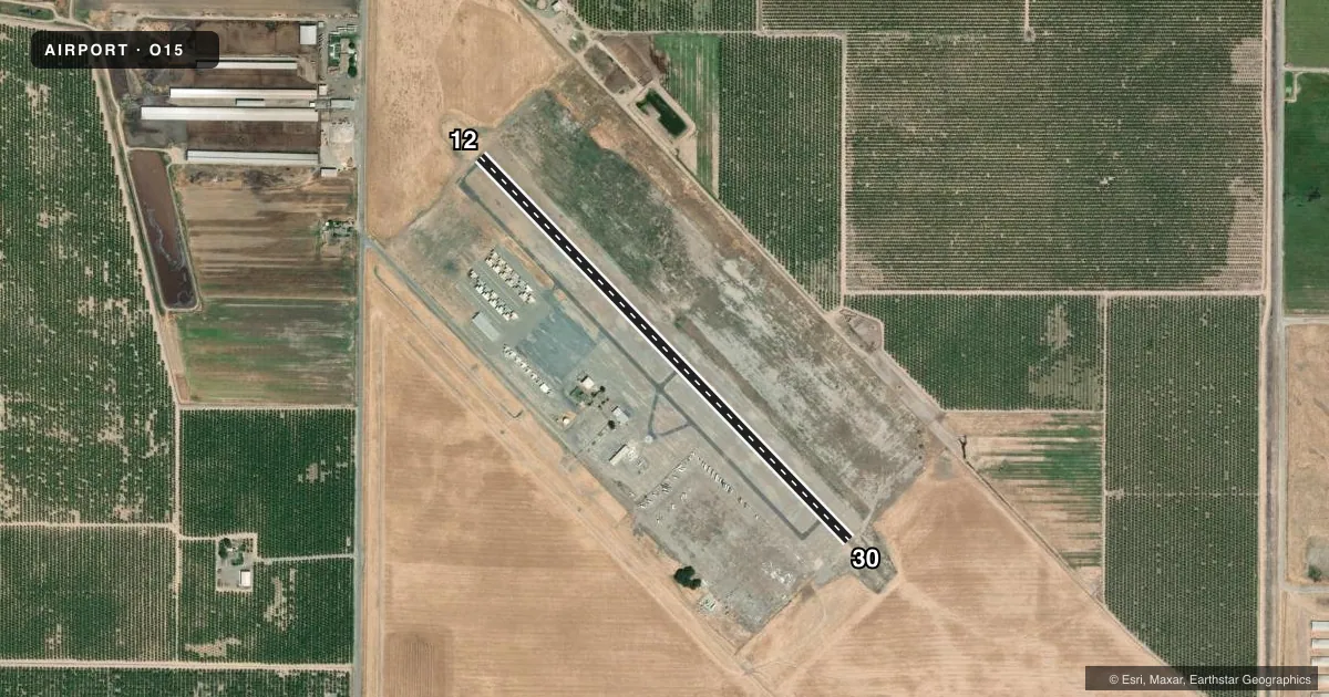
Airport sketch
Runways drawn to scale from FAA survey coordinates, rendered over satellite imagery. Not for navigation.
Approaches & charts
Services on the field
Fuel grades, oxygen, maintenance, ramp storage and lighting — as declared to the FAA by the airport operator.
Fuel & services
- Fuel
- 100LL
- Oxygen (bottled)
- Not available
- Oxygen (bulk)
- Not available
- Airframe repair
- Not available
- Power plant repair
- Not available
Ramp & ground
- Transient storage
- Tie-down
- Landing fee
- No fee published
- Customs
- Not available
- Lighting schedule
- SEE RMK
- Beacon schedule
- SS-SR
- Beacon
- White / Green (civil land)(WG)
- Wind indicator
- Lighted
- Segmented circle
- Yes
Fuel & FBOs
Cheapest 100LL and Jet A on the field and nearby. Always confirm with the FBO before taxi.
Airport notes
Surface conditions, obstructions, local procedures, lighting outages and other notes published with each FAA cycle.
General notes
- FOR CD CTC NORCAL APCH AT 916-361-0516.
Lighting notes
- ACTVT LIRL RWY 12/30 - CTAF.
Fuel notes
- 100LLFUEL AVBL 24 HRS SELF SERVE CC.
Runway surface & condition
- 12/30NSTD LIRL; LGTS 20 FT FM EDGE OF RY.
Approach & departure obstructions
- 12MRKGS ARE FADED AND NSTD.
Other notes
- ESTABD PRIOR TO 15 MAY 1959.
- OWNERATTN: ERICK SCHULZE
- MANAGERX 4604
- 12/30RWY IS CRACKED AND RAVELING.
VFR map & nearby airports
VFR sectional. Tap any ICAO chip to open that airport.
Key facts · O15
Answer card- ICAO
- O15
- Name
- TURLOCK MUNI
- Location
- TURLOCK, CALIFORNIA
- Elevation
- 160.8 ft MSL
- Traffic pattern altitude
- 960.8 ft MSL (800 AGL)
- Control tower
- Non-towered (use CTAF)
- Total runways
- 1
- Longest runway
- 12/30 · 2,985 ft
- Published ILS approaches
- 0
- Published frequencies
- 4
- Magnetic variation
- 16°
- Current flight rules
- VFR
- Current wind
- 330° at 15 kt
- Favored runway now
- RWY 30
Turlock Muni sits in Turlock, California. Field elevation is 160.8 ft MSL. The airport has one runway, 12/30, which is 2,985 ft long and asphalt. There is no control tower. Pattern altitude is 800 ft AGL, which is 960.8 ft MSL.
No ILS approaches are published here. For clearance delivery, contact NorCal Approach at 916-361-0516. CTAF and UNICOM are both 122.8. Published remarks say runway 12/30 has low intensity lights that are activated on CTAF. They also note the runway markings on 12 are faded and nonstandard. The runway surface is cracked and raveling, so plan your rollout and taxi with that in mind.
There are no on-field FBOs listed in the facts. Fuel is available 24 hours self serve with credit card. First-time visitors should also note the runway lighting is nonstandard, with the lights set 20 feet from the runway edge. That is worth keeping in mind on a night arrival. Check the current FAA Chart Supplement for any other local procedures before you go.