METAR & TAF KTCY
Current METAR
Observed 13:35Z
KTCY 271335Z AUTO 14004KT 10SM CLR 15/09 A2995 RMK A01
- Wind
- 140° @ 4 kt
- Visibility
- 10 SM
- Temp / Dew
- 15°C / 9°C
- Altimeter
- 29.95 inHg
- Clouds
- CLR
- Density alt
- 203 ft
- Ceiling
- Unlimited
- Rules
- VFR
Airport info & contacts
Manager on record, flight service, ARTCC, attendance schedule and pattern altitude — published by the FAA and refreshed every 28 days.
Location
- From city
- 3 NM SW
- VFR sectional
- SAN FRANCISCO
- Pattern altitude
- 800 ft AGL · 994 ft MSL
- ARTCC
- ZOA · OAKLAND
- NOTAM facility
- TCY (NOTAM-D)
Airport manager
- Name
- DAVID MURPHY
- Phone
- 209-831-6349
- Address
- 520 N. TRACY BLVD, TRACY CA 95376-4917
Flight service · Hours
- FSS RIU
- RANCHO MURIETA1-800-WX-BRIEF
- Attendance
- 0800-1800
Frequencies
Tap any row to copy the frequency to your clipboard.
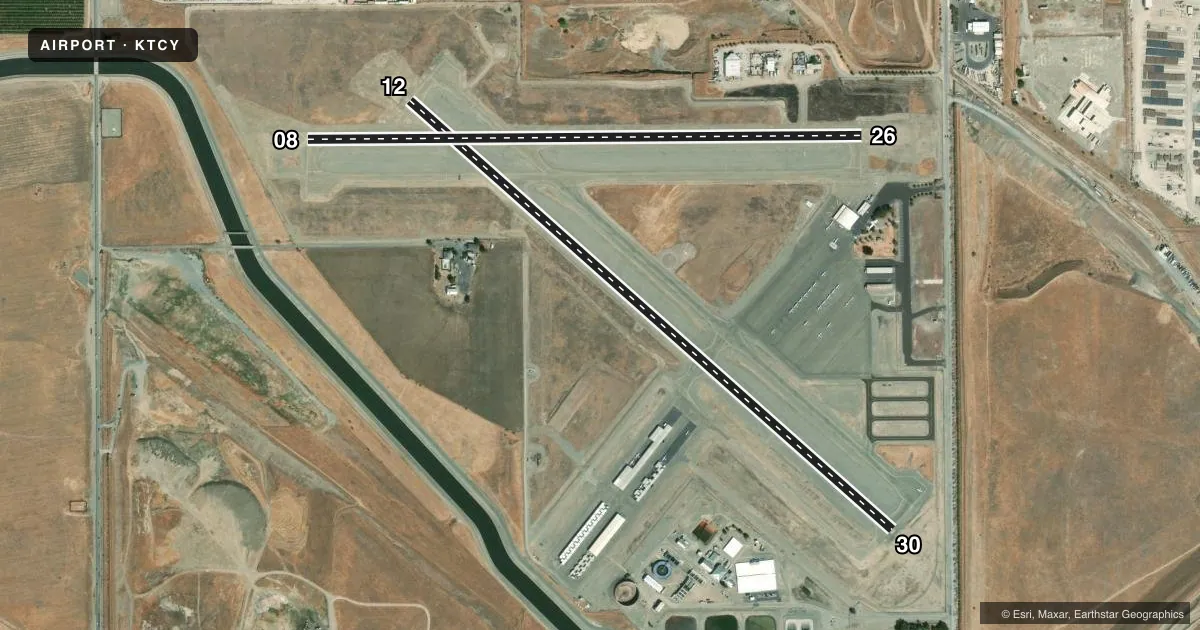
Runways & pattern
Full pagePattern entry · RWY 12
LEFT TRAFFIC| Runway | Heading (°M) | Length | Surface | Traffic |
|---|---|---|---|---|
| 12/30Favored | 117° / 297° | 4,001 ft | ASPH | Standard L |
| 08/26 | 75° / 255° | 3,438 ft | ASPH | Standard L |
Runway end performance
| End | TORA | TODA | ASDA | LDA | VGSI | Approach lights | Obstruction |
|---|---|---|---|---|---|---|---|
| 12 | — | — | — | — | PAPI 2-box left(3°) | — | 25', bldg, 1100' from thr, 0' R of cntrln, slope 36 |
| 30 | — | — | — | — | PAPI 2-box left(3°) | — | 15', road, 510' from thr, 280' R of cntrln, slope 20 |
| 08 | — | — | — | — | PAPI 2-box left(3.4°) | — | 8', fence, 350' from thr, 140' R of cntrln, slope 18 |
| 26 | — | — | — | — | PAPI 2-box left(3°) | — | 15', road, 500' from thr, 0' R of cntrln, slope 20 |
Declared distances in feet. TORA = takeoff run available, TODA = takeoff distance, ASDA = accelerate-stop, LDA = landing distance.
Airport sketch
Runways drawn to scale from FAA survey coordinates, rendered over satellite imagery. Not for navigation.
Approaches & charts
Services on the field
Fuel grades, oxygen, maintenance, ramp storage and lighting — as declared to the FAA by the airport operator.
Fuel & services
- Fuel
- 100LLA
- Oxygen (bottled)
- Low pressure
- Oxygen (bulk)
- Not available
- Airframe repair
- Major
- Power plant repair
- Major
- Other services
- INSTR,RNTL
Ramp & ground
- Transient storage
- Tie-down
- Landing fee
- No fee published
- Customs
- Not available
- Lighting schedule
- SEE RMK
- Beacon schedule
- SS-SR
- Beacon
- White / Green (civil land)(WG)
- Wind indicator
- Lighted
- Segmented circle
- Yes
Fuel & FBOs
Cheapest 100LL and Jet A on the field and nearby. Always confirm with the FBO before taxi.
Airport notes
Surface conditions, obstructions, local procedures, lighting outages and other notes published with each FAA cycle.
General notes
- BALLOON AND PARAPLANE ACTIVITY ON THE AIRPORT.
- AEROBATIC AREA ADJ/WI 1 SMR FROM 500 AGL - 3000 MSL SR-SS.
- TWO 150 FT PWR PLANT STACKS APPROX 3 NM NW OF ARPT. WATCH FOR PSBL TURB.
- FOR CD CTC NORCAL APCH AT 916-361-0516.
Lighting notes
- ACTVT REIL RWY 08, 26, 12, & 30; PAPI RWY 08, 12 & 26; MIRL RWY 08/26 & 12/30 - CTAF. PAPI RWY 30 IS OPRD AT NGT BY CTAF FROM SS TO SR AND IS ON DRG DALGT HRS.
Approach & departure obstructions
- 12UNUSBL BYD 5 DEGS LEFT OF CNTRLN.
VFR map & nearby airports
VFR sectional. Tap any ICAO chip to open that airport.
Key facts · KTCY
Answer card- ICAO
- KTCY
- Name
- TRACY MUNI
- Location
- TRACY, CALIFORNIA
- Elevation
- 193.6 ft MSL
- Traffic pattern altitude
- 993.6 ft MSL (800 AGL)
- Control tower
- Non-towered (use CTAF)
- Total runways
- 2
- Longest runway
- 12/30 · 4,001 ft
- Published ILS approaches
- 0
- Published frequencies
- 4
- Magnetic variation
- 15°
- Current flight rules
- VFR
- Current wind
- 140° at 4 kt
- Favored runway now
- RWY 12
Tracy Muni is in Tracy, California. The field elevation is 193.6 ft MSL. It has two asphalt runways. The longest is runway 12/30 at 4,001 ft. This is a non-towered field, so expect self-announce traffic on CTAF 123.075. Coordinate with UNICOM as needed.
No ILS approaches are published here. Pattern altitude is 800 ft AGL, which is 993.6 ft MSL. NORCAL handles approach and departure on 123.85 or 278.3. For clearance delivery, contact NorCal Approach at 916-361-0516. The airport sits in a busy part of the Central Valley. Balloon and paraplane activity occurs on the airport. An aerobatic area is also adjacent within 1 statute mile from 500 ft AGL up to 3,000 ft MSL from sunrise to sunset.
The on-field FBO is Tracy Municipal Airport. It carries 100LL and Jet A. Runway lighting is pilot-controlled by CTAF on both runways. PAPI is published on 08, 12 and 26. The PAPI on runway 30 is operated at night by CTAF from sunset to sunrise. Two 150 ft power plant stacks sit about 3 NM northwest of the airport. Expect possible turbulence in that area. The visual glide slope indicator on runway 12 is unusable beyond 5 degrees left of centerline.