METAR & TAF O20
O20 does not publish a METAR.
Showing the nearest reporting station: KSCK (STOCKTON METRO) · 13.1 NM away. Conditions at O20 may differ.
METAR · KSCK
Observed 12:55Z
KSCK 271255Z AUTO 31004KT 10SM CLR 14/11 A2995 RMK AO2 SLP140 T01390111
- Wind
- 310° @ 4 kt
- Visibility
- 10 SM
- Temp / Dew
- 14°C / 11°C
- Altimeter
- 29.95 inHg
- Clouds
- CLR
- Density alt
- -135 ft
- Ceiling
- Unlimited
- Rules
- VFR
Airport info & contacts
Manager on record, flight service, ARTCC, attendance schedule and pattern altitude — published by the FAA and refreshed every 28 days.
Location
- From city
- 4 NM SW
- VFR sectional
- SAN FRANCISCO
- Pattern altitude
- 800 ft AGL · 818 ft MSL
- ARTCC
- ZOA · OAKLAND
- NOTAM facility
- RIU (NOTAM-D)
Airport manager
- Name
- AMRITPAL (RICK) GREWAL
- Phone
- 209-986-0797
- Address
- 4100 EAST FREMONT STREET, STOCKTON CA 95215
Flight service · Hours
- FSS RIU
- RANCHO MURIETA1-800-WX-BRIEF
- Attendance
- IREG · IREG · ON CALL
Frequencies
Tap any row to copy the frequency to your clipboard.
Runways & pattern
Full pagePattern entry · RWY 30
LEFT TRAFFICRunway end performance
| End | TORA | TODA | ASDA | LDA | VGSI | Approach lights | Obstruction |
|---|---|---|---|---|---|---|---|
| 12 | — | — | — | — | — | — | 3', fence, 200' from thr, 5' R of cntrln, slope 0 |
| 30 | — | — | — | — | TRIL(4.5°) | — | 15', road, 300' from thr, 135' R of cntrln, slope 6 |
Declared distances in feet. TORA = takeoff run available, TODA = takeoff distance, ASDA = accelerate-stop, LDA = landing distance.
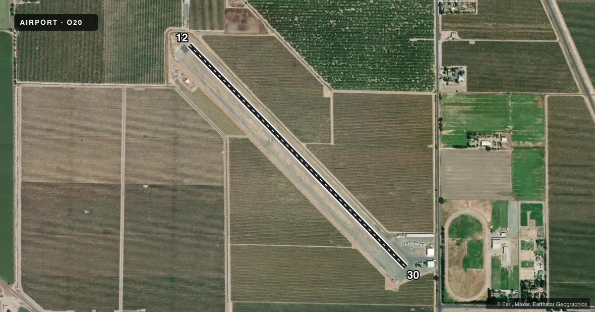
Airport sketch
Runways drawn to scale from FAA survey coordinates, rendered over satellite imagery. Not for navigation.
Approaches & charts
Services on the field
Fuel grades, oxygen, maintenance, ramp storage and lighting — as declared to the FAA by the airport operator.
Fuel & services
- Fuel
- 100LL
- Oxygen (bottled)
- Not available
- Oxygen (bulk)
- Not available
- Airframe repair
- Not available
- Power plant repair
- Not available
Ramp & ground
- Transient storage
- Tie-down
- Landing fee
- No fee published
- Customs
- Not available
- Lighting schedule
- SEE RMK
- Wind indicator
- Yes
- Segmented circle
- No
Fuel & FBOs
Cheapest 100LL and Jet A on the field and nearby. Always confirm with the FBO before taxi.
Airport notes
Surface conditions, obstructions, local procedures, lighting outages and other notes published with each FAA cycle.
General notes
- TWY CLSD INDEFLY.
- ACFT PARKED 115 FT LEFT OF RWY 30 CNTRLN SE END OF RWY PRIOR TO DSPLCD THLD.
- FOR CD CTC NORCAL APCH AT 916-361-0516.
Lighting notes
- FOR LIRL RWY 12/30 KEY 122.8 5 TIMES.
Fuel notes
- 100LLSELF-FUELING FAC AVBL 24/7.
Runway surface & condition
- 12/30GROSS PAVEMENT STRENGTH PRVDD BY MGR; 15000 LBS.
- 12/30NSTD EDGE LGTS 40 FT FROM EDGE OF RWY; RWY 12 LGTD THLD RELCTD 105 FT; RWY 30 LGTD THLD RELCTD 385 FT FOR NGT OPNS. 3360 FT OF RWY 12/30 USBL AT NGT.
Approach & departure obstructions
- 123 FT FENCE 0-200 FT FM RY END; +2 FT DIRT PILES 0 FT FM RY END 50 FT L & 40 FT FM RY END 100 FT R.
- 30+15' LGT POLE 130' FM RY END 100' R; AUTO PARKING LOT IN E CORNER OF PRIMARY SURFACE.
- 12RWY MRKGS POOR DUE TO CRACKED AND SPALLING ASPH.
- 30RWY MRKGS POOR DUE TO CRACKED AND SPALLING ASPH WITH EXCESSIVE RUBBER BUILD-UP IN THE TDZ.
- 30RY 30 VASI OTS INDEFLY.
- 12APCH RATIO 50:1 FROM DSPLCD THR +3 FT FENCE 135 FT LEFT.
- 30RWY 30 APCH RATIO TO DSPLCD THR 50:1;
Other notes
- REMOVAL OF OBSTNS IN PRIMARY & APCH SFCS; ESTAB THR 495' FROM END RWY 30 & 118' FROM END RWY 12. VFR OPNS ONLY.
- 1CTC AMGR AT 209-986-0797
- MANAGEREMAIL: AGPROJECT@SBCGLOBAL.NET
- 12/30RWY 30 CRACKED AND SPALLING WITH EXCESSIVE RUBBER BUILD-UP IN TDZ.
- 12/30NW 1000 FT ROUGH SFC.
VFR map & nearby airports
VFR sectional. Tap any ICAO chip to open that airport.
Key facts · O20
Answer card- ICAO
- O20
- Name
- KINGDON AIRPARK
- Location
- LODI, CALIFORNIA
- Elevation
- 18.1 ft MSL
- Traffic pattern altitude
- 818.1 ft MSL (800 AGL)
- Control tower
- Non-towered (use CTAF)
- Total runways
- 1
- Longest runway
- 12/30 · 3,851 ft
- Published ILS approaches
- 0
- Published frequencies
- 2
- Magnetic variation
- 16°
- Current flight rules
- VFR
- Current wind
- 310° at 4 kt
- Favored runway now
- RWY 30
Kingdon Airpark is in Lodi, California. Field elevation is 18.1 ft MSL. It has one runway, 12/30, which is 3,851 ft long and asphalt. There is no control tower. Pattern altitude is 800 ft AGL, which is 818.1 ft MSL. No ILS approaches are published here.
This is a VFR-only field per the published remarks. The taxiway is closed indefinitely. Plan on runway use and ground movement with that in mind. The runway has displaced thresholds. Runway 12 has a threshold relocated 105 feet. Runway 30 has a threshold relocated 385 feet for night operations. Only 3,360 feet of runway 12/30 is usable at night. The northwest 1,000 feet of the surface is rough. Runway markings are also reported as poor due to cracked and spalling asphalt.
There are no on-field FBOs listed in the facts. Contact the airport operator or the airport manager before arrival if you need current services. The airport manager is listed in the Chart Supplement remarks. For a first-time visit, pay close attention to the displaced thresholds, the obstructions near runway 12 and the reduced night usable length. Check the current FAA Chart Supplement before flying in for any updated operational notes.